CLEAR LAKE (TX), TX Campground Reservation, Info, Images, Map, Directions

CLEAR LAKE (TX), Texas Campground Images, Info & Reservations

Directions

While traveling on US Highway 380 in Princeton, TX, take South 2nd Street (County Road 982) South. County Road 982 changes into County Road 735. At the 4 way stop sign (just past the Lavon Lake Camp and Conference Center), take a right on County Road 436. Watch for Clear Lake signs. Take County Road 436 and follow into Clear Lake Park.

Phone

972-442-3014

Activities

BOATING, CAMPING

Keywords

CLEL,LAVON LAKE,LAKE LAVON,LAVON LAKE

Related Link(s)

Rec Area Info & Images

Texas State Road Conditions

Texas State Tourism

Overview

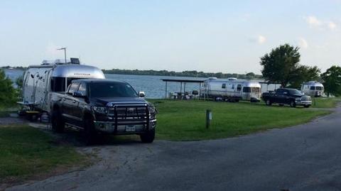
Clear Lake Campground has a prime location on the shores of Lavon Lake. It is the only shaded campground at the lake, and provides a quiet space for anglers, bird watchers and photographers.

The park is just northeast of Dallas, Texas, and just east of the Southfork Ranch, where the hit TV series, “Dallas,” was filmed.

Recreation

Visitors of all ages enjoy outdoor opportunities like fishing, boating, hiking, and picnicking. Anglers often find channel catfish, crappie, striped bass and hybrid bass.

Facilities

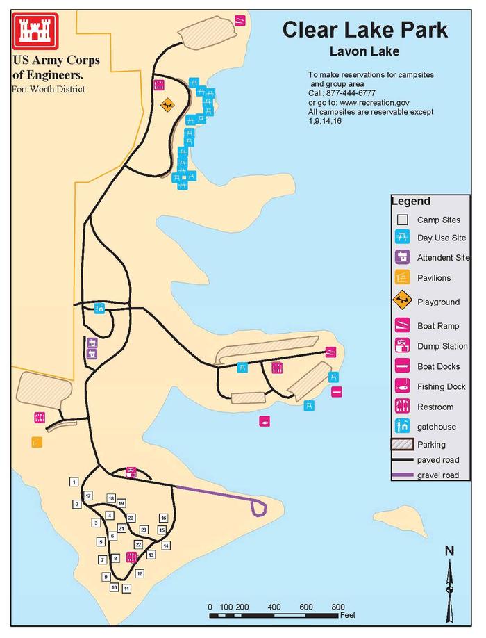
The Clear Lake Campground offers 23 sites with water, sewer and electric hookups. Hot showers, a boat ramp and fishing dock are also available. The group campground fits 200 people and has toilets reserved solely for group campers. The picnic shelter at the group site comes with electric and water hookups, four cookers, and a campfire ring. There’s also a large playing field for sports.

Natural Features

Grassy flat fields and leafy shade trees cover the campground. The Lavon Lake spans 21,400 acres and stems from the East Fork of the Trinity River.

Nearby Attractions

The town of Wylie is home to a wildlife rescue and education center. Visitors can see lions, leopards, cougars, bobcats and more.

Reservation

More from CampingHiking.net:

SPENCER CREEK, Oklahoma Campground Images, Info & Reservations

Directions Campground is 15 miles from Oologah, Oklahoma via county roads. Phone 918-341-3690 Activities BOATING, CAMPING, FISHING, VISITOR CENTER, WATER SPORTS, SWIMMING SITE Keywords SPEN,OOLOGAH LAKE,OOLOGAH LAKE Related Link(s) Rec Area Info & Images Oklahoma State Road Conditions Oklahoma State Tourism Overview Spencer Creek is located on Oologah Lake in

COUGAR FLAT, Washington Campground Images, Info & Reservations

Directions Take Highway 410 to milepost 88.4, then turn left on Bumping Lake Road and continue for 6 miles. Phone 541-338-7869 Activities BIKING, BOATING, CAMPING, FISHING, HIKING, HORSEBACK RIDING, VISITOR CENTER, WILDLIFE VIEWING Keywords COUG,BUMPING RIVER,NACHES,OKANOGAN – WENATCHEE NF -FS Related Link(s) Rec Area Info & Images Washington State Tourism

OAK CABIN, Colorado Campground Images, Info & Reservations

Directions From Grand Junction, head south on Highway 50. Take a right on County Road 141 heading south for 14.5 miles. Make a sharp left on Divide Road. This road is not marked, but prior to turn, a sign reads "National Forest Access Divide Road, Uncompahgre Plateau." Follow this road

STONY POINT, Minnesota Campground Images, Info & Reservations

Directions From Walker, Minn., take Highway 200 east 6 miles to County Road 13. Go north 3 miles on County Road 13 to Forest Road 3793, then east 2.5 miles on FR 3793 to the campground. Phone 218-547-1044 Activities BOATING, CAMPING, FISHING, HIKING, SWIMMING SITE Keywords STOP,CHIPPEWA NF – FS

SPANISH CREEK CAMPGROUND, California Campground Images, Info & Reservations

Directions From Oroville, travel east on Highway 70 for 75 miles. The turnoff to the campground is two miles past Highway 89. From Quincy, travel west on Highway 70 for 8 miles. Campground is across the Spanish Creek bridge. Phone 530-283-0555 Activities CAMPING, FISHING, HIKING, WATER SPORTS, SWIMMING SITE Keywords