HIGH VIEW, TX Campground Reservation, Info, Images, Map, Directions

HIGH VIEW, Texas Campground Images, Info & Reservations

Directions

From Ennis, Texas: From Interstate 45, exit onto U.S. Highway 287 Bypass (Exit #247). Travel 4.5 miles and exit at the Bardwell Lake exit sign. Turn left onto Highway 34 and go 2.5 miles southwest. After crossing the Bardwell Lake bridge, take the first left onto High View Park Road. Travel 0.2-mile to the High View Park entrance station.

Phone

972-875-5711

Activities

BOATING, CAMPING, PICNICKING, SWIMMING SITE

Keywords

HIGV,BARDWELL LAKE,LAKE BARDWELL,BARDWELL,HIGHVIEW PARK,BARDWELL LAKE

Related Link(s)

Rec Area Info & Images

Texas State Road Conditions

Texas State Tourism

Overview

High View Park is on a long peninsula on the western shore of Bardwell Lake, less than an hour south of the Dallas-Fort Worth area in north-central Texas.

The lake has favorable fish and wildlife habitats, providing plenty of opportunities for fishing and hunting, and great locations for camping, boating and hiking. Deer, armadillo, rabbit, squirrel and a variety of bird species inhabit the area.

Recreation

Many local fishermen consider Bardwell Lake one of the best kept secrets in the state. Bass fishermen seldom leave empty-handed. Crappie fishing is moderate, and catfish are usually excellent.

The lake has a marina with fishing piers, two of which are enclosed (a small fee is charged for the use of these facilities), and there are several designated hunting areas around the lake, including those for duck hunting.

Facilities

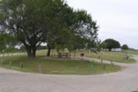
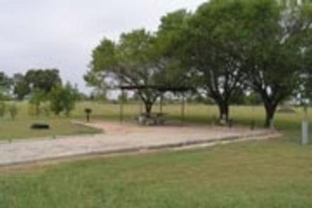
High View Park offers 21 campsites with water and 50-amp electric hookups, 18 campsites with water and 30-amp electric hookups, 10 picnic sites and one reservable group picnic pavilion, accommodating up to 50 people.

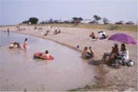
A swimming area with covered benches, a full-service marina, four-lane boat ramp and a courtesy dock make access to the lake easy. While public restrooms with showers help provide a comfortable camping experience.

Natural Features

The park is grassy and partially forested with a mix of shade and sun. The lake’s cool, blue water provides a refreshing break from the Texas heat, while bluebonnets and other wildflowers surround the lakeshore each spring.

Nearby Attractions

Numerous amenities, as well as cultural and historical attractions, lie in the nearby cities of Dallas and Fort Worth.

Reservation

More from CampingHiking.net:

FISHTRAP LAKE SHELTERS, Kentucky Campground Images, Info & Reservations

Directions From US-460/Shelbiana Road, continue approximately five miles, then make a slight right onto Kentucky Route 1789/Fishtrap Road. Continue three miles to the Fishtrap Lake Dam Site Recreation Area. Shelter # 1 is the first right turn after entering the dam site, located approximately one mile below the dam. Located

WAX, Kentucky Campground Images, Info & Reservations

Directions From Louisville, take I-65 south to exit 76 and turn west onto Highway 224. After 9 miles turn left on Highway 479, then continue for another 8 miles and turn left onto Highway 88. Continue into the campground entrance. Phone 270-242-7578 Activities BOATING, CAMPING, FISHING, HIKING Keywords WAXX,NOLIN LAKE,NOLIN

HAWKER POINT, Missouri Campground Images, Info & Reservations

Directions From Stockton, Missouri, take State Highway 39 south for 6.2 miles, turn left on Highway H and continue for 5.2 miles to the park entrance. Phone 417-276-7266 Activities BOATING, CAMPING, FISHING, VISITOR CENTER, WILDLIFE VIEWING Keywords HAWK,STOCKTON LAKE,STOCKTON LAKE Related Link(s) Rec Area Info & Images Missouri State Tourism

TETILLA PEAK, New Mexico Campground Images, Info & Reservations

Directions From Albuquerque, New Mexico, take I-25 north to exit 264. Travel west on State Road 16 to the Tetilla Peak Recreation Area/La Bajada Village turnoff and follow the paved road into the recreation area. Phone 505-465-0274 Activities BOATING, CAMPING, FISHING, HIKING, SWIMMING SITE Keywords TPEA,COCHITI LAKE Related Link(s) Rec

FARNSWORTH CABIN, Pennsylvania Campground Images, Info & Reservations

Directions If traveling on Route 6, in the town of Claredon, turn at the street light onto Railroad Road, continue toward Chapman Dam. Turn left on Farnsworth Rd., travel approximately 7 miles and the cabin will be on your right, look for the Trout Hatchery sign. For details, click here,

WINDY GROUP CAMP, Oregon Campground Images, Info & Reservations

Directions Take Highway 58 approximately 8 miles east of Willamette Pass to the Crescent Lake Junction. Turn west on Forest Road 60 and continue approximately 7 miles to the campground. Phone 541-323-1746 Activities BOATING, CAMPING, FISHING, HIKING, SWIMMING SITE Keywords WING,DESCHUTES NF – FS Related Link(s) Rec Area Info &