PARADISE COVE, CA Campground Reservation, Info, Images, Map, Directions

PARADISE COVE, California Campground Images, Info & Reservations

Directions

From Bakersfield, California, take Highway 178 east to the town of Lake Isabella. Staying on 178 east, travel approximately 3 miles to Paradise Cove Campground.

Phone

760-376-1815

Activities

BOATING, CAMPING

Keywords

PARD,LAKE ISABELLA,KERN VALLEY,SEQUOIA NF – FS

Related Link(s)

Rec Area Info & Images

California State Road Conditions

California State Tourism

Forest Service Concessionaire

Overview

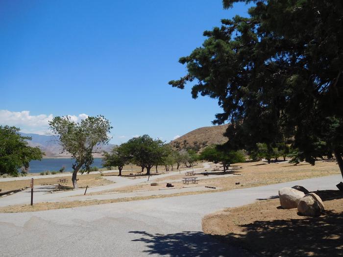
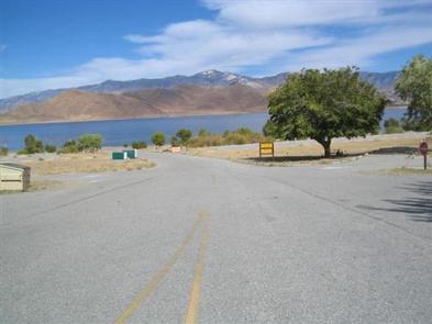
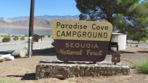
Paradise Cove Campground sits near Lake Isabella in the beautiful Sequoia National Forest. The 11,000-acre lake marks the division between the Upper and Lower Kern Rivers.

Recreation

This year-round campground is near Lake Isabella, one of California’s largest reservoirs. Water activities such as swimming, water skiing and wind surfing are popular.

The lake is known for trout fishing during the colder months. Other species include black and white crappie, bluegill, catfish and largemouth bass.

Facilities

The campground has 46 sites that are divided into two sections. The upper section has back-in camp sites, and the lower section has side-by-side parking. All camp sites have a view of the lake.

This facility is operated by Sequoia Recreation, a division of California Land Management and comments are welcome; comment forms are available from campground hosts or online.

Natural Features

The Sequoia National Forest, located at the southern end of the Sierra Nevada in central California, takes its name from the giant sequoia, the world’s largest tree, which grows in more than 30 groves on the Forest’s lower slopes.

The Forest comprises about 1.1 million acres, and elevations range from about 1,000 to 12,000 feet creating precipitous canyons and mountain streams with spectacular waterfalls such as Salmon Creek Falls and Grizzly Falls.

Nearby Attractions

The campground provides a great base for day trips to the Trail of a Hundred Giants and numerous Sequoia groves in the Giant Sequoia National Monument. You cannot access Sequoia National Park with a day trip.

The Giant Sequoia Mercantile offers a wide variety of books, maps, gifts, local art, camping supplies and other merchandise.

Reservation

More from CampingHiking.net:

CLEAR LAKE GROUP SITE, Washington Campground Images, Info & Reservations

Directions From Naches, Washington, follow Highway 12 west for approximately 34 miles to County Road 1200/Tieton Reservoir Road at the west end of Rimrock Lake. Turn south/left on County Road 1200 and follow for about .3 miles to Road 740. Continue for a half-mile, and the reservation site is the

PURGATOIRE CAMPGROUND, Colorado Campground Images, Info & Reservations

Directions From La Veta, Colorado, take State Route 12 south for 25.3 miles to Purgatoire campground sign. Turn right onto gravel Route 34. Go 0.2 miles to "T" intersection. Turn right and drive 4 miles on rough gravel road to campground. Phone FOR RESERVATIONS CALL (877) 444-6777, FOR OTHER NON

JOPLIN, Arkansas Campground Images, Info & Reservations

Directions From Hot Springs, Arkansas: Take US 270 west for 23.5 miles to Mountain Harbor Road. Turn right and follow access road three miles north to the park. Phone 870-867-4472 Activities BIKING, BOATING, CAMPING, FISHING, WATER ACTIVITIES, KAYAKING, CANOEING Keywords JOPL,LAKE OUACHITA,MOUNTAIN HARBOR,LAKE OUACHITA Related Link(s) Rec Area Info &

METHODIST COVE, Nebraska Campground Images, Info & Reservations

Directions From U.S. Highway 80, take Highway 183 south to Alma, Nebraska. Turn left on South Street and travel 2.5 miles. The park entrance is on south side of the road. Phone 308-799-2105 Activities BOATING, CAMPING, FISHING, HUNTING Keywords METH,HARLAN COUNTY LAKE,METHODIST,HARLAN COUNTY LAKE Related Link(s) Rec Area Info &

POINT SUPREME CAMPGROUND, Utah Campground Images, Info & Reservations

Directions Routes to Cedar Breaks National Monument Traveling south on I-15: Take exit 78 to Parowan Travel south on Main Street for 1.3 miles Turn left onto E. Center Street. Travel 0.3 Miles Turn right onto Utah Highway 143 East Continue approximately 15 miles to Cedar Breaks National Monument Traveling