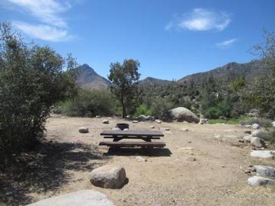
GOLDLEDGE CAMPGROUND, CA Campground Reservation, Info, Images, Map, Directions

GOLDLEDGE CAMPGROUND, California Campground Images, Info & Reservations

Directions

From Bakersfield, take Highway 178 east to Lake Isabella. From Lake Isabella, take Highway 155 around the west side of the lake to the town of Kernville. From Kernville, go 10 miles north on Sierra Way (Mountain 99) to the campground.

Phone

760-376-1815

Activities

BOATING, CAMPING

Keywords

GOED,KERN RIVER,UPPER KERN CANYON,SEQUOIA NF – FS

Related Link(s)

Rec Area Info & Images

California State Road Conditions

California State Tourism

Forest Service Concessionaire

Overview

Goldledge Campground is situated along the Kern River, 10 miles north of the town of Kernville. Hiking, fishing, kayaking and rafting are popular activities.

Recreation

Hiking, fishing, kayaking and rafting are popular activities in the Upper Kern River area. Click here to learn more about the area, including safety and permitting requirements and a listing of local outfitters.

Facilities

The campground offers single-family sites, some of which are designated for walk-to tent camping only. Picnic tables and campfire rings are provided, as are vault toilets and drinking water.

Natural Features

The campground sits within Sequoia National Forest at an elevation of 3,200 feet in an open area with limited shade, overlooking the Kern Wild and Scenic River. Gray pine, scrub oak, grasses and shrubs cling to steep, canyon walls along the river, and cottonwoods and willows dot the riverbanks.

Sequoia National Forest, located at the southern end of the Sierra Nevada in central California, is named for the giant sequoia, the world’s largest tree, which grows in more than 30 groves on the forest’s lower slopes.

The forest comprises about 1.1 million acres. Elevations range from about 1,000 to 12,000 feet, creating precipitous canyons and mountain streams with spectacular waterfalls such as Salmon Creek Falls and Grizzly Falls.

Nearby Attractions

The Cannell Meadow National Recreation Trail begins just north of Kernville. The trail stretches 11.5 miles as it climbs through mixed pine and fir forest to Cannell Meadow and a historic Forest Service cabin built between 1904 and 1909. Hikers are awarded beautiful views of the Kern River Valley along the trip.

Visitors enjoy making day trips to Sequoia National Park and Giant Sequoia National Monument.

Reservation

More from CampingHiking.net:

GROUSE CREEK GROUP SITE, Washington Campground Images, Info & Reservations

Directions Grouse Creek Campground is located approximately 7 miles up the Forest Service Road 6200/Chiwawa River Road. There is a gated spur road just off the main paved road on the left. The campground is at the end of the road alongside Grouse Creek. Phone 509-763-0700 Activities BIKING, CAMPING, FISHING,

AUK VILLAGE CAMPGROUND, Alaska Campground Images, Info & Reservations

Directions From the cruise ship terminal on South Franklin Street in downtown Juneau, head northwest along the waterfront. South Franklin Street becomes Marine Way, then Egan Drive, named for William A. Egan (1914 – 1984), first governor of the State of Alaska. Egan Drive becomes Glacier Highway at Milepost 9.4,

BLIND PASS CABIN, Alaska Campground Images, Info & Reservations

Directions The cabin is located approximately 40 air miles north of Ketchikan on the northwest shore of Hassler Island, across from Black Island. Accessible by float plane or by boat. Mooring buoy in front of cabin is first-come, first-serve. Refer to USGS topographic map, Ketchikan D-5, and check local tide

LOOKOUT BUTTE LOOKOUT, Idaho Campground Images, Info & Reservations

Directions Travel to Lowell, Idaho, located approximately midway between Lewiston, Idaho and Missoula, Montana on Highway 12, milepost 97. Cross the Selway Bridge, drive 3.5 miles and cross the Swiftwater Bridge on your right. Follow the signs 13 miles for about 1 hour to the lookout. Alternative Route From Hwy

PLOTNIKOF LAKE CABIN, Alaska Campground Images, Info & Reservations

Directions Accessible early June through October. This cabin is located 45 miles southeast of Sitka, 4 miles east of Whale Bay, on the south-central part of Baranof Island. Access by floatplane is 40 minutes from Sitka. For geographic features surrounding the cabin, refer to USGS topographic map Port Alexander C-3.