NARROWS CAMPGROUND, WY Campground Reservation, Info, Images, Map, Directions

NARROWS CAMPGROUND, Wyoming Campground Images, Info & Reservations

Directions

From Pinedale, take U.S. Highway 191 northwest for 6 miles. Turn north onto State Highway 352 and travel just over 14 miles. Turn east onto New Fork Lake Road, which is gravel, and travel 5 miles to the campground. Though the road is suitable for two wheel drive vehicles the road is rough and weather condtions can affect road surface. Call the district office for road conditions.

Phone

307-367-4326

Activities

BOATING, CAMPING, FISHING, HIKING, WILDLIFE VIEWING, SWIMMING SITE

Keywords

NARO,BRIDGER-TETON NF – FS

Related Link(s)

Rec Area Info & Images

Overview

Narrows Campground is located next to scenic New Fork Lake, at the edge of the Wind River Range in northwestern Wyoming. Visitors enjoy hiking and horseback riding into the adjacent Bridger Wilderness, as well as boating and fishing on the lake.

Recreation

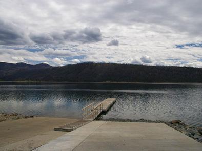
New Fork Lake offers great boating, canoeing and swimming. Anglers fish for kokanee salmon, brook, lake and rainbow trout. A large cement boat ramp is located less than one mile from the campground.

New Fork Trail, for hiking and horseback riding, begins at the campground entrance and provides back country access through New Fork Canyon into the Bridger Wilderness. The trail also connects with several other trails in the area. Horse corrals are located at the trailhead.

Facilities

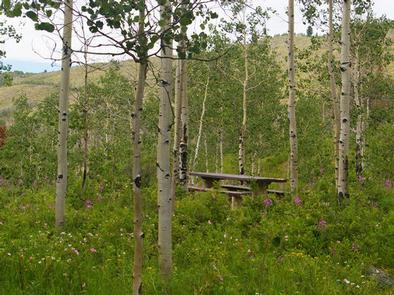
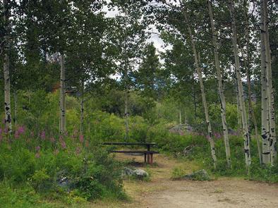
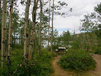
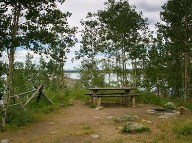
The campground contains single-family campsites with picnic tables and campfire rings. Amenities include two vault toilets located at convenient locations and a campground host is located on-site. Roads and parking spurs throughout the campground are native soils.

Natural Features

The campground is situated above New Fork Lake, in a dense grove of aspens, at an elevation of 7,800 feet. Shade is plentiful in most sites throughout the campground. Most sites afford scenic lake views. Summer wildflowers vividly carpet the campground. A variety of wildlife makes its home around the lake.

Nearby Attractions

Pinedale is 26 miles away and is the nearest full-service community.

Reservation

More from CampingHiking.net:

DELTA, Oregon Campground Images, Info & Reservations

Directions Located 51 miles from Eugene OR on HWY 126 to the Cougar Reservoir turn off. Take a right turn (south) on Aufderheide Drive and cross the McKenzie River, turn right on to the campground entrance road Forest Road 400. Follow the road approximately 1 mile to the campground. Phone

EAST TWIN, Wisconsin Campground Images, Info & Reservations

Directions Drive 4 miles north from Clam Lake on County Highway GG. Turn right (east) on Forest Road 190 and continue for about one mile to the campground. Phone (715) 634-4821 OR (715) 264-2511 Activities BIKING, BOATING, CAMPING, FISHING, HIKING Keywords EATW,CHEQUAMEGON-NICOLET NF – FS Related Link(s) Rec Area Info

The Ledge Group Sites, Utah Campground Images, Info & Reservations

Directions From Moab, drive 10 miles on the Kane Creek Road. The group site is on the left hand side of the road. Phone 435-259-2100 Activities CAMPING, HIKING, PHOTOGRAPHY, MOUNTAIN BIKING, SCENIC DRIVE Keywords Related Link(s) Rec Area Info & Images Utah State Tourism Utah State Road Conditions Overview The

NORTH FORK (WY), Wyoming Campground Images, Info & Reservations

Directions From Centennial, Wyoming, take State Highway 130 west for 3.7 miles to Sand Lake Road/Forest Road 101. Turn right and drive 2 miles to the campground. Phone 307-745-2300 Activities BIKING, CAMPING, FISHING, HIKING Keywords NOR1,MEDICINE BOW-ROUTT NF-FS Related Link(s) Rec Area Info & Images Wyoming State Tourism Overview North

ASPENGLEN CAMPGROUND, Colorado Campground Images, Info & Reservations

Directions Aspenglen Campground is located off Highway 34 just inside the Fall River Entrance of Rocky Mountain National Park. Phone 970-586-1206 Activities CAMPING, FISHING, HIKING, HORSEBACK RIDING, VISITOR CENTER, DAY USE AREA Keywords Rocky,Rocky Mountain National Park,Aspen Campground Related Link(s) Rec Area Info & Images Colorado State Tourism Colorado State

LOWER HYALITE GROUP, Montana Campground Images, Info & Reservations

Directions From Main Street in Bozeman, travel south on 19th Avenue for 7 miles, to the paved Hyalite Canyon Road. Turn left and continue south for two miles, to the group area. Phone 406-646-1012 Activities BOATING, CLIMBING, CAMPING, FISHING, HIKING, WILDLIFE VIEWING, PHOTOGRAPHY, BERRY PICKING, STAR GAZING, BIRDING, BACKPACKING Keywords