


Directions
Access to the cabin is by float plane or canoe with portage. It is about a 45-minute flight from Juneau. By canoe and portage, it is about 6.5 miles from Mole Harbor. Click here for for information about Admiralty Island Canoe Route and portage. This cabin is in a designated Wilderness area, and access by helicopter is illegal.
In the fall, winter, and early spring, the cabin may be inaccessible due to frozen lake surface (float planes cannot land). The lake is typically ice-free from mid-May through November. Refer to USGS topographic map Sitka C-1, C-2. Click here for information about reaching Forest Service Cabins.
Phone
907-586-8800
Activities
BOATING, CAMPING, FISHING, HIKING, WILDLIFE VIEWING
Keywords
HABC,HASSELBORG SHELTER CABIN,HASSELBORG RIVER CABIN,TONGASS NF – FS
Related Link(s)
Overview
Hasselborg Creek Cabin offers guests access to a variety of recreational activities, relaxation and a unique wilderness lodging experience in the central part of Admiralty Island in the Tongass National Forest. The remote site offers a scenic setting for hiking, fishing, canoeing and wildlife viewing, all within the vicinity of the cabin.
The cabin is one of three on Hasselborg Lake, which is seven miles long and part of the Admiralty Island Canoe Route. Access to the cabin is float plane or canoe with portage. Visitors are responsible for their own travel arrangements and safety, and must bring several of their own amenities.
Recreation
Hasselborg Lake offers fishing for cutthroat trout, Dolly Varden and kokanee salmon. The lake outlet is one of the better areas to cast a fishing line. A small fishing boat with oars is provided at the cabin, but guests must bring their own life jackets and a small, outboard motor, if they choose.
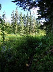
Several primitive trails extend from the cabin into the forest. Trails accessible by boat from Hasselborg Lake lead to Lake Guerin, Beaver Lake, Lake McKinney, and Hasselborg River. Lake Guerin and Beaver Lake are on the Admiralty Island Canoe Route, offering guests access to pristine wilderness settings.
Facilities
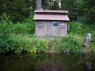
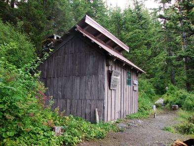
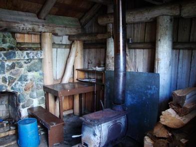
Built in the 1930s, Hasselborg Creek Cabin is a small, adirondack shelter. It is furnished with a single bunk bed without mattresses, and sleeps up to two guests. The cabin has a concrete floor and stone fireplace, and is equipped with a table, benches, a small cook area, a wood stove for heat and an outside toilet. Firewood is generally stacked in a woodshed near the cabin, but it is not guaranteed. The cabin does not have running water or electricity. Guests must bring their own food, water, sleeping bags, sleeping pads, cook stoves, matches, cooking gear/utensils, light source, toilet paper, first aid kit and garbage bags. Water from any natural source must be filtered, boiled or chemically treated before use. Click here for more cabin details.
Natural Features
At an elevation of 300 feet, the cabin is situated under a dense canopy of a spruce-hemlock forest, at the southern end of scenic Hasselborg Lake. The cabin is just steps away from the lake.
The cabin is located in the Kootznoowoo Wilderness which encompasses 956,255 acres of the island. Dense spruce and hemlock forests, glacier-fed streams, lakes and muskeg openings define the landscape, while rocky peaks tower along the island’s high crest, reaching elevations of over 3,000 feet.
Sitka black-tailed deer make a home in the dense forest and bald eagles perch in treetops along most beaches. Brown bears frequent the area as well (earn more about bear safety).
Nearby Attractions
Admiralty Island also has a rich cultural heritage, which is evident in the traditional native village of Angoon, the island’s only permanent settlement.