
Directions
Located on the southwest tip of Yakobi Island, across Lisianski Strait from Chichagof Island, Greentop Cabin is accessible only by floatplane or boat. The cabin is tucked in the northeast corner of Greentop Harbor. Access by float plane 1 hour flight time (one way) from Sitka or Juneau, 35 minute flight time from Hoonah. Access by boat 1 hour from Pelican. There is safe anchorage for boats, but use charts to enter the harbor and take it slow; there are uncharted rocks. Float planes can land easily. Please consult local tide tables before departing for the cabin. This cabin is in a designated Wilderness area, and access by helicopter is not authorized.
Phone
(907) 945-3631
Activities
BOATING, CAMPING, FISHING, HIKING, HUNTING, PICNICKING, WILDLIFE VIEWING, WILDERNESS, PHOTOGRAPHY, MOTOR BOAT, CANOEING, BERRY PICKING, SEA KAYAKING, BIRDING, NON-MOTORIZED BOATING, GOLD PANNING
Keywords
GROP,TONGASS NF – FS
Related Link(s)
Overview
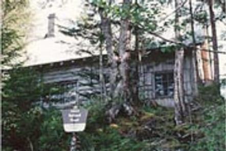
Greentop Cabin is located on the southwest tip of Yakobi Island within the West Chichagof-Yakobi Wilderness Area. The cabin was built in the 1940s by a fisherman. It is available year-round and makes an excellent base for experiencing this corner of Alaska with its many recreational options. The cabin is remote. It is located approximately 41 miles west of Hoonah and 67 miles northwest of Sitka. It is accessible only by boat or float plane. The flight is 1 hour from Sitka or Juneau and the boat ride is 1 hour from Pelican. This is a primitive cabin with no electricity, indoor plumbing or cell phone coverage. Visitors are responsible for their own travel arrangements and safety, and must bring several of their own amenities.
Recreation
There are excellent opportunities for sea kayaking and boating in the numerous coves and protected bays. However, there are rocks in the area, so boating and kayaking excursions should be planned for high tide. Consult local tide tables.
Fishing for king salmon is also a popular pastime. For information about fishing permits and seasons, visit the Alaska Department of Fish and Game website.
Facilities
The 2-story log cabin accommodates 6 people and contains 1 double and 3 single bunks, a table and benches, a cooking area, a broom and dust pan. A wood stove is provided for heat. Firewood is generally available, but is not guaranteed. An outhouse is located close to the cabin. Drinking water is not available at the cabin, but water can be collected from a small stream nearby. It is recommended that visitors bring a supply of drinking water. Visitors should bring sleeping bags, sleeping pads, a cook stove and cooking gear, lantern or flashlight, food, toilet paper, garbage bags, a fire extinguisher and fire starter. Rain gear and boots are recommended. Visitors are expected to pack out their trash and food and clean the cabin before leaving.
Natural Features
The cabin sits on relatively flat terrain near the rugged, rocky coastline of Yakobi Island. It is protected from the Pacific Ocean by Greentop Harbor. The surrounding area offers abundant seashore life and the beautiful scenery of West Chichagof-Yakobi Wilderness Area. Deer and brown bear frequent the area, and sea otters are sometimes seen (bear safety and precautions).