

Directions
Beach River Cabin is only accessible by wheeled plane on the beach at low tide from Anchorage, Cordova or Seward. Travel time is 40 minutes southwest of Cordova, 45 minutes east of Seward. Click here for local tide information.
Phone
1 (907) 424-7661
Activities
BOATING, CAMPING, FISHING, HUNTING, WILDLIFE VIEWING
Keywords
BRIV,CHUGACH NF – FS
Related Link(s)
Overview
Beach River Cabin offers guests a remote lodging experience on Montague Island in southcentral Alaska. Situated 200 yards south of Beach River on the Gulf of Alaska, the cabin offers guests year-round recreation and relaxation. Fishing, hunting, kayaking, beachcombing and wildlife viewing are within walking distance of the facility. Access to the cabin is by wheeled plane only on the beach at low tide from Anchorage, Cordova or Seward. Visitors are responsible for their own travel arrangements and safety, and must bring several of their own amenities.
Recreation
Anglers will find that Montague Island is a prime fishing location. Coho salmon start showing up at the mouth of Beach River in mid-August, while pink salmon enter the system in mid-July. Fishing at the mouth of the river gives anglers the chance to catch the fish straight from the ocean when they’re at their strongest and freshest. Montague Island has been referred to as “The Land of the Giants” by sport fishing enthusiasts, producing a variety of fish over 100 pounds, including a 350-pound halibut caught in 2007.
Hunters can take advantage of a long hunting season in the surrounding forest. Bear season occurs during spring and fall, while deer season begins in late summer and lasts through late fall.
The intertidal beach adjacent to the cabin is open for public use below mid-level high tide. Contact the Cordova Ranger District for a detailed map of land ownership in this area. Since the cabin is on the Gulf of Alaska and the open ocean, the beach is a good place for beachcombers to search for glass Japanese fishing floats and other sea-borne treasures.
Facilities
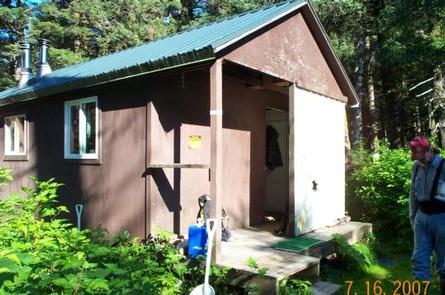
This 12×14-foot rustic, pre-cut cedar log cabin is equipped with wooden bunks that sleep up to six guests. Other amenities include a table, benches, wood and oil stoves for heat, a rainwater catchment barrel and an outdoor pit toilet.
Firewood may be available, but the supply cannot be guaranteed. Visitors are asked to be conservative with wood and use their cook stoves for cooking.
Water and heating oil are not provided at the cabin. Visitors need to bring their own supply of water and #1 stove oil. Any water collected from natural sources must be boiled or treated before using.
Visitors must bring food, sleeping bags, sleeping pads, a cook stove, matches, cooking gear, lanterns or flashlights, toilet paper, a first aid kit and garbage bags. All trash and food must be packed out, and visitors are expected to clean the cabin before leaving.
Natural Features
Montague Island is in the Gulf of Alaska at the entrance to Prince William Sound. The cabin sits in a mature spruce tree stand approximately a half-mile from the intertidal beach landing area.
The area is defined by a thick spruce and hemlock forest, and an understory of shrubs and grasses. The pebble-strewn shoreline offers expansive views of the water and surrounding mountains.
Wildlife in the area abounds, including migratory waterfowl, Sitka black-tail deer and brown bear (bear safety).