
Directions
Access to the cabin is by float plane, canoe or a 2.25-mile hike through dense forest.
Hiking access begins at McKinley Lake Trail, a signed trailhead located at Mile 21 of the Copper River Highway.
Access by boat or canoe is up Alaganik Slough to McKinley Lake, approximately 2 miles. If paddling a canoe, check with the Forest Service office on the stream conditions. When the glaciers melt and there has been rain, the stream can get a little rowdy. Hazards include trees that have fallen across the creek. Boat access is best at high water in mid-June to September.
Access by float plane is typically 10 minutes from Cordova. Float planes land on the lake next to the cabin. In fall, winter, and early spring, the cabin may be inaccessible to float planes due to the frozen lake surface. Please contact the local Forest Service Ranger District office at (907) 424-7661 for information prior to making reservations for these periods.
Phone
1 (907) 424-7661
Activities
BOATING, CAMPING, FISHING, HUNTING, WILDLIFE VIEWING
Keywords
MCLA,CHUGACH NF – FS
Related Link(s)
Overview
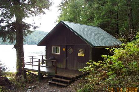
McKinley Lake Cabin offers guests recreation, relaxation and a remote lodging experience in southcentral Alaska. Located on the northwest end of McKinley Lake in the Chugach National Forest, guests will find fishing, hiking, hunting and wildlife viewing all within the vicinity. Access to the cabin is by hiking, float plane or canoe. Visitors are responsible for their own travel arrangements and safety, and must bring several of their own amenities.
Recreation
McKinley Trail provides access to both the McKinley Trail Cabin, located just 100 yards from the trailhead, and this cabin, which is about 2.25 miles from the trailhead. The trail meets the shoreline of the lake at its southern lobe and at the cove at its upper end. Hiking approximately a quarter-mile beyond the cabin, visitors will find remnants of the Lucky Strike Mine. Rusting machinery, pipes and a collapsed tunnel are the most obvious evidence of the mine site.
At approximately 1.25 miles from the McKinley Trail trailhead is the junction for the Pipeline Lakes Trail, which wanders through muskeg meadows and spruce-hemlock forests below steep mountainsides. In the spring, brown bears can be seen grazing on the new grass on the south-facing slopes.
Anglers will find cutthroat trout near inlet creeks and gravel shoals near the cabin, and more healthy coho and sockeye at the mouth of the lake outlet. Many anglers concentrate on the Dolly Varden that follow the sockeye to eat their eggs. Walking up the Pipeline Lakes Trail, anglers will discover a series of five small lakes with resident cutthroat trout and some Dolly Varden. Using dry flies is the best bet in these lakes.
Hunters can take advantage of a long hunting season in the surrounding national forest. Bear season occurs during spring and fall, while deer season begins in late summer and lasts through late fall.
Facilities
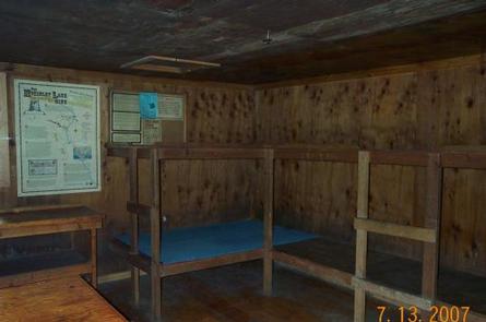
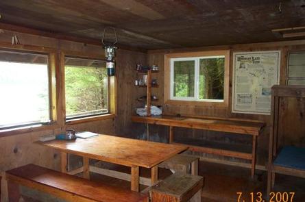
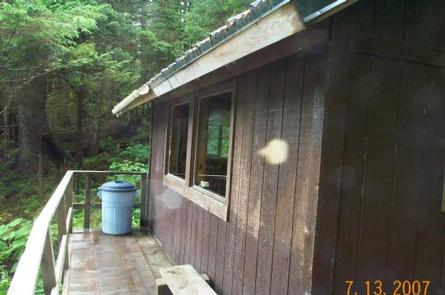
The 16-by-20 cabin is equipped with wooden bunks that sleep up to six guests. The cabin is equipped with a table, benches, wood stove for heat, saw, axe, splitting maul, a rainwater catchment barrel and an outdoor pit toilet.
The cabin does not have running water, electricity or cut firewood. Visitors must bring their own supply of drinking water and firewood.
Visitors must bring food, sleeping bags, sleeping pads, a cook stove, matches, cooking gear, lanterns or flashlights, toilet paper, a first aid kit and garbage bags. All trash and food must be packed out, and visitors are expected to clean the cabin before leaving.
Natural Features
The cabin is situated on McKinley Lake and is surrounded by a dense spruce and hemlock forest. Steep mountainous terrain encircles the area.
Visitors will be treated to an abundance of wildlife. Loons and other waterfowl find habitat on the lake, while sockeye salmon splash and spawn in the nearby creek. Sitka black-tailed deer, moose, black and brown bear also inhabit the forest. Learn more about bear and moose safety in Alaska.