

Directions
From Petersburg, it is 16 miles by float plane or 30 miles by boat. A 16-foot tide is required for direct boat or float plane access to the cabin. At lower tides, there is up to a 2-mile hike across the sometimes muddy tide flat to get to the cabin. Another option for access is to boat or fly to the Castle Flats Cabin (a 15-foot tide is required for float plane, or a 13-foot tide for boat access there) and hike the easy 0.5-mile trek to the cabin.
The Castle River Cabin can be found on USGS topographic map Petersburg C-4. Maps are available online or by calling the Petersburg Ranger District at (907) 772-3871.
Phone
(907) 772-3871
Activities
CAMPING, FISHING, HIKING, HUNTING, WILDLIFE VIEWING
Keywords
CARV,UPPER CASTLE CABIN,TONGASS NF – FS
Related Link(s)
Overview
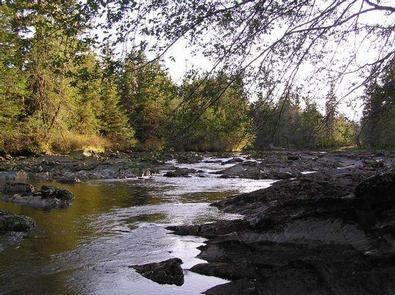
Castle River Cabin is located on Kupreanof Island on the coastal waters of southeastern Alaska. It offers access to a variety of outdoor recreational opportunities, as well as a secluded place to enjoy its beautiful surroundings.
The cabin is accessible only by boat or float plane from Petersburg or Wrangell, and tides impact access. During low tides, a 2-mile hike is necessary to reach the cabin. Guests are responsible for their own travel arrangements and safety, and must bring several of their own amenities.
Recreation
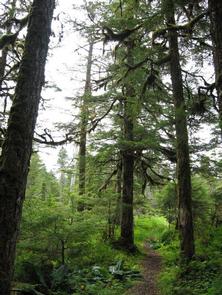
The Castle River Trail leads a half-mile downstream to the Castle Flats Cabin, and a half-mile upstream to a rowboat and oars. Wildlife can be seen along the trail. Waterfowl, grouse, moose, deer and bear hunting is also available in designated seasons as per state or federal hunting regulations; click here for more information from the Alaska Department of Fish and Game.
Visitors also enjoy fishing for steelhead trout from April to May, trout from May to October, and coho salmon in mid-August through mid-September.
Boating is a popular way to explore the area, but a 16-foot tide is required to cross the tide flats in front of the cabin (local tide tables). Life jackets are not available; visitors must bring their own. Visitors may also choose to bring a small outboard motor for the rowboat.
Facilities
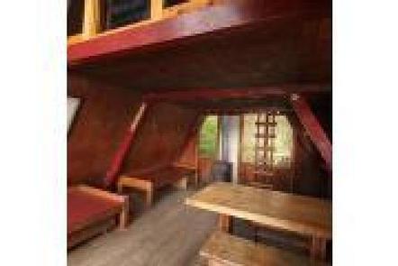
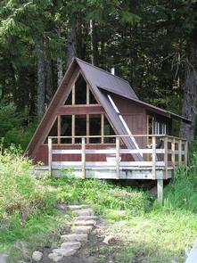
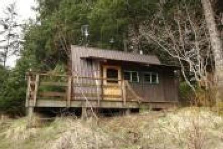
The modified A-frame cabin has an extended roof and an upright wall to form a bump-out. It has two double bunks and a sleeping loft to accommodate a total of seven people. The cabin is also equipped with a table, benches, a wood stove and an outhouse with a pit toilet. Firewood is generally available, but is not guaranteed. Firewood is for heating the cabin only, not for outdoor campfires. A broom, dust pan, axe and splitting maul are generally available, but may be missing or damaged. Drinking water is not available at the cabin. Water is available in the nearby river or streams, but it must be treated or boiled prior to consumption. It is recommended that visitors bring their own supply of water for drinking, cooking and cleaning. Visitors need to bring sleeping bags and pads, a cook stove and cooking gear, towels, food, clothing and garbage bags, among other necessities. All trash and food must be packed out, and visitors are expected to clean the cabin before leaving. Click here for more cabin details and maps.
Natural Features
The cabin is located inside a large tide flat on Kupreanof Island at the mouth of the Castle River on the west side of Duncan Canal. The surrounding terrain is predominantly flat-to-rolling old-growth forest and muskeg.
A variety of wildlife makes its home in the area, including moose, deer, black bears, waterfowl and grouse (learn more about bear safety).