


Directions
The Raven’s Roost Cabin is located above Petersburg Airport. The distance is 3 miles by helicopter or 4 miles by hiking trail from the trailhead at the water towers behind the airport. The first mile of the trail is moderate, the middle section is very steep, and the final mile flattens along the ridge top. Allow 3 hours for ascent.
Refer to USGS topographic map Petersburg D3. Petersburg C3 may also be helpful. Maps are available online or by calling the Petersburg Ranger District at (907) 772-3871.
Phone
907-772-3871
Activities
CAMPING, HIKING, WINTER SPORTS, WILDLIFE VIEWING
Keywords
RAVR,RAVEN S ROOST CABIN,TONGASS NF – FS
Related Link(s)
Overview
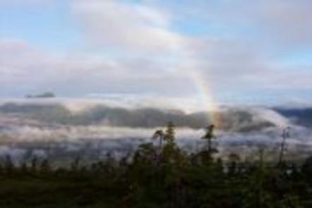
Ravens Roost Cabin is on the Alexander Archipelago in southeast Alaska. It sits at the top of a mountain in a very scenic area, providing views of surrounding terrain and access to a variety of recreational opportunities. Visitors enjoy cross country skiing and snowshoeing, as well as wildlife viewing and berry picking.
The cabin can be accessed by helicopter or a 4-mile trail from behind the airport in Petersburg. Guests are responsible for their own travel arrangements and safety, and must bring several of their own amenities.
Recreation
The area is popular among snowmobile enthusiasts, cross-country skiers, telemark skiers and snowshoers. During summer months the surrounding muskegs bloom with several species of wildflowers and wild berries. A trail to the north of the cabin connects to Petersburg, while a winter ski trail is marked to the south linking to the Twin Creeks road.
Facilities
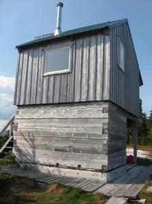
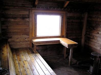
The cabin has two single wooden bunks and a sleeping loft to accommodate up to eight people. It is equipped with a deck, a table and benches, an oil heater and an outhouse with a pit toilet. A supply of heating oil is provided in the storage area below the cabin from November to April, but is not guaranteed. Report low oil levels to the Petersburg Ranger District.
The only fresh water available is from nearby muskeg pools or melted snow. Water taken from any outdoor source should be treated or boiled before consumption. Guests are encouraged to bring drinking water if possible.
Guests will need to bring their own sleeping bags and pads, cook stove and cooking gear, towels, food, clothing, fire starter and garbage bags, among other necessities. Guests are advised to bring a small supply of No. 1 heating oil for the oil heater in case the supply has been exhausted.
Click here for more cabin details and maps.
Natural Features
The cabin is located on Mitkof Island, on the mountain above Petersburg Airport, at an elevation of 1,745 feet. It is the only cabin accessible by trail from Petersburg. The cabin is a custom-built alpine design, allowing access through a door in the loft during periods of deep winter snow.
Terrain surrounding the cabin is flat muskeg and beyond that is steep mountain slopes. The cabin offers nice views of the Wrangell Narrows and Kupreanof Island to the west. A variety of wildlife can be seen in the area, including eagles, moose, deer, porcupines and black bears (learn about bear safety).