


Directions
The cabin is accessible by boat or float plane only and the journey is about 18 miles by boat and 16 miles by plane from Petersburg. The cabin is accessible at any tide, but care should be taken when entering the cove at high tide because boats can go dry quickly. Some float plane operators will not enter the cove at just any tide because of poor visibility through the water. Please check current conditions prior to your trip. Click here for more information. Refer to USGS topographic map Sumdum A3. Maps are available online or by calling the Petersburg Ranger District at (907) 772-3871.
Phone
907-772-3871
Activities
BOATING, CAMPING, FISHING, WILDLIFE VIEWING
Keywords
SPUR,TONGASS NF – FS
Related Link(s)
Overview
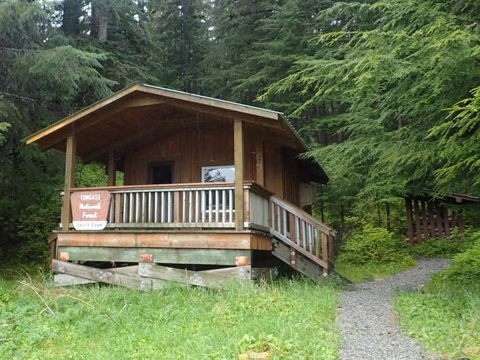
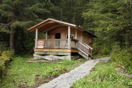
The Spurt Cove Cabin is located on the mainland, in a small cove on the north side of Thomas Bay. It makes a good base camp for exploring Thomas Bay, a favorite destination among boaters and kayakers. The cabin provides its own scenic views and also provides access to a variety of recreational activities.
The cabin is accessible by boat or float plane only.
Recreation
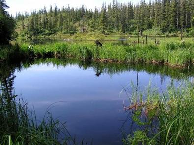
Halibut and king salmon fishing is available in the bay, while anglers may find trout in the beaver ponds behind the cabin. Orca whales and porpoises can also often be seen in the area.
A moderately difficult 1.1-mile trail to Spurt Lake starts a quarter-mile northeast of the cabin. The trail is marked by red and white diamond stakes. A boat is necessary to access the trailhead.
The Thomas Bay area offers numerous options for single and multiple-day trips to Baird, Muddy and Patterson glaciers, Scenery Cove and the Cosmos Mountain Range. Kayaking is popular in the protected waters of Thomas Bay.
Facilities
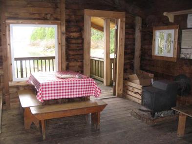
The hunter-style cabin has two wooden bunks that can accommodate up to four people. It is equipped with a table, benches, a clean-burning oil heater for heat and a wood stove that can be used for cooking purposes. An outhouse with a pit toilet is provided.
Water for drinking, cooking and cleaning is not provided at the cabin. The nearest water source is a small stream near the cabin. Water taken from any outdoor source should be treated or boiled before consumption. Guests are encouraged to bring drinking water if possible.
Guests will need to bring their own sleeping bags and pads, cook stove and cooking gear, towels, food and clothing, fire starter and garbage bags, among other necessities. Guests are advised to bring enough kerosene or No. 1 heating oil for the oil heater. It burns at a rate of approximately one gallon per day. Oil is not supplied at the cabin.
A broom, dust pan, axe and splitting maul are generally available, but may be missing or damaged. Please report missing or damaged items to the Petersburg Ranger District. The cabin needs to be cleaned prior to leaving and all garbage and food must be carried out.
Click here for more cabin details and maps.
Natural Features
The cabin is located in southeastern Alaska’s Tongass National Forest, which is the largest national forest in the United States. The terrain surrounding the cabin is predominantly gently sloping with some steep bluffs. Spurt Cove is known for its interesting rock formations.