


Directions
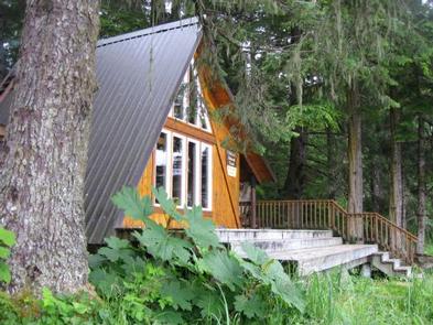
The West Point Cabin is located near the mouth of Portage Bay on Kupreanof Island. It is situated west of West Point, just around the point from Fredrick Sound. It is 18 miles by float plane or 24 miles by boat from Petersburg.
The cabin can be found on USGS topographic maps Sumdum A4, Sumdum A5, Petersburg D4 and Petersburg D5. Maps are available online or by calling the Petersburg Ranger District at (907) 772-3871.
Float plane or boat access can only occur at certain stages of the tide. Please check current conditions prior to your trip. Click here for more information.
Phone
907-772-3871
Activities
BOATING, CAMPING, FISHING, HIKING, HUNTING, WILDLIFE VIEWING
Keywords
WENT,PORTAGE BAY CABIN,TONGASS NF – FS
Related Link(s)
Overview
The West Point Cabin is located near the mouth of Portage Bay on Kupreanof Island. It provides a tranquil place to stay amid very scenic surroundings. The cabin also offers access to a variety of recreational activities, including hiking, fishing and boating, as well as whale-watching at Fredrick Sound.
The cabin is accessible by boat or float plane only.
Recreation
The area surrounding the cabin offers various points of exploration and the beach has excellent hiking opportunities. Visitors enjoy fishing and boating. Anglers might catch king salmon in May and June, coho in August through September and halibut in Fredrick Sound. The waters of Frederick Sound and Stephen’s Passage are primary feeding grounds for migratory humpback whales and provide excellent whale watching opportunities; click here for more information.
Hunting is available as per state or federal hunting regulations; click here for more information from the Alaska Department of Fish and Game.
Facilities
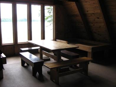
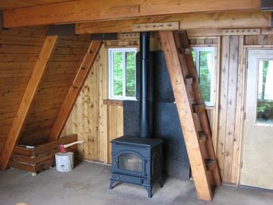
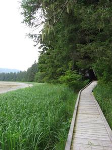
The cabin, wooden access walkway and outhouse are all designed to meet accessibility standards. It has wooden bunks and a sleeping loft to accommodate up to seven people. It has a table, benches, a cooking counter, wood stove and a large deck. Firewood is supplied, but not guaranteed. A wheelchair ramp is located on the beach.
Water for drinking, cooking and cleaning is not provided at the cabin. The nearest water source is a small creek about a half-mile west of the cabin. Water taken from any outdoor source should be treated or boiled before consumption. Because of the long distance to the creek, guests are encouraged to bring drinking water if possible.
Guests will need to bring their own sleeping bags and pads, flashlights and lanterns, cook stove and cooking gear, towels, food and clothing, toilet paper, fire starter and garbage bags, among other necessities. A broom, dust pan, axe and splitting maul are generally available, but may be missing or damaged. Please report missing or damaged items to the Petersburg Ranger District. The cabin needs to be cleaned prior to leaving and all garbage and food must be carried out.
Click here for more cabin details and maps.
Natural Features
The cabin is a barrier-free, modified A-frame structure built in 1994. It is situated west of West Point, just around the point from Fredrick Sound. The cabin overlooks Portage Bay. The surrounding terrain is flat with mixed spruce and hemlock forest. Large expanses of gravel beach are excellent for beach hiking.
A variety of wildlife make its home in the area, including black bears, deer, waterfowl and whales in Fredrick Sound. Click here to learn about bear safety.