TANIS MESA SOUTH CABIN, AK Campground Reservation, Info, Images, Map, Directions

TANIS MESA SOUTH CABIN, Alaska Campground Images, Info & Reservations

Directions

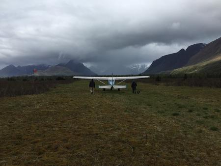
The cabin is located 50 miles southeast of Yakutat between Tanis Mesa and Brabazon Mountain Range. Access is by wheeled plane only via an 1,800-ft. airstrip at the cabin.

Phone

(907) 784-3359

Activities

CAMPING, HIKING, HUNTING, WILDLIFE VIEWING

Keywords

TANS,TONGASS NF – FS

Related Link(s)

Rec Area Info & Images

Alaska State Tourism

Alaska State Road Conditions

Overview

Tanis Mesa South Cabin is located in a duplex with Tanis Mesa North Cabin. The cabin is tucked between Tanis Mesa and the Brabazon Mountain Range, offering year-round relaxation and recreation. The site can be accessed by wheeled plane, depending on conditions. An airstrip is adjacent to the cabin. Visitors are responsible for their own travel arrangements and safety, and must bring several of their own amenities.

Recreation

Tanis Lake is 2 miles north of the cabin and can be hiked to relatively easily except for the last quarter mile, which is dense brush. Hikers are rewarded with views of Fassett Glacier cascading into the lake’s northeast end.

The Brabazon Mountains offer opportunities for excellent mountain goat hunting. Moose and brown bear hunting is good around the cabin.

Facilities

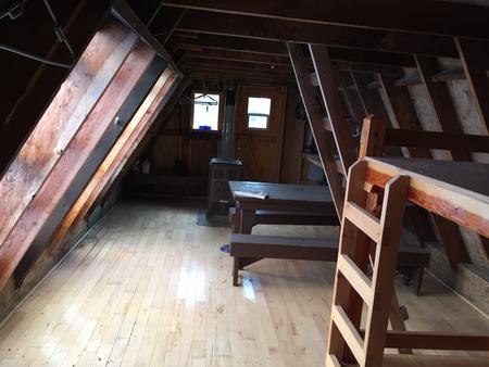
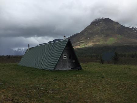
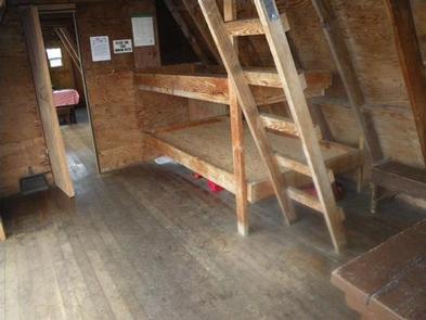
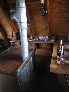
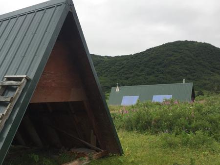
This is the south half of a 14×40-ft. A-frame stylecabin. It sleeps five people and comes equipped with four single bunks and a sleeping loft. The cabin also has a table and benches, oil heater, broom, picnic table, fire ring and outhouse. A 12×12-ft. meat shed is located outside, which is shared with Tanis Mesa North Cabin.

Water, heating oil and electricity are not provided. Visitors must supply #1 diesel oil the heater, as well as their own drinking water. Other items to bring include sleeping bags, sleeping pads, food, a cooking stove, cookware, plates, utensils, lanterns or flashlights, toilet paper, garbage bags, a fire extinguisher and fire starter. Visitors are expected to pack out trash and clean the cabin before leaving. Click here for more cabin details.

Natural Features

The cabin sits on mostly flat terrain surrounded by blueberry bushes. Interspersed stands of cottonwood, alder and willow begin about half a mile from the cabin. Visitors can enjoy views of Tanis Mesa, which sits half a mile to the southwest. Tanis Mesa is a unique geologic feature that stands about 500 feet above the cabin. The peaks of the Brabazon Range are a mile to the northeast, with elevations of over 3,000 feet. Wildlife in the Brabazon Mountain Range includes moose, brown bear and mountain goats.

Reservation

More from CampingHiking.net:

RACCOON BRANCH CAMPGROUND, Virginia Campground Images, Info & Reservations

Directions From I-81, take Marion exit 45 onto Virginia State Route 16 South. Follow SR 16 South for approximately 13 miles to the campground on the right. Phone 800-628-7202 Activities BIKING, CAMPING, FISHING, HIKING, WILDLIFE VIEWING Keywords RACC,GEORGE WASHINGTON/JEFFERSON NF-FS Related Link(s) Rec Area Info & Images Virginia State Road

DYERS CREEK, Tennessee Campground Images, Info & Reservations

Directions From Nashville, Tenn, take I-24 West to the Clarksville Exit 8. Take US-79S for 46 miles to Dyers Creek Recreation Area. Phone 931-232-7724 DOVER OFFICE; 270-362-4236 LAKE BARKLEY RESOURCE MANAGERS OFFICE Activities BOATING, HISTORIC & CULTURAL SITE, FISHING, VISITOR CENTER, DAY USE AREA Keywords DYER,LAKE BARKLEY,BARKLEY LOCK & DAM

BELKNAP, California Campground Images, Info & Reservations

Directions From Springville, California, proceed east on State Highway 190 for approximately 15 miles. Turn east on Nelson Drive and continue about a mile to the campground. Phone 559-539-5230 Activities BIKING, CAMPING, FISHING, HIKING Keywords BELK,GIANT SEQUOIA NATIONAL MONUMEN,SEQUOIA NF – FS Related Link(s) Rec Area Info & Images California

PRAIRIE CREEK (AR), Arkansas Campground Images, Info & Reservations

Directions From Rogers, Arkansas, take Highway 12/Prairie Creek Drive east for just over 3 miles. Turn left onto North Park Road and follow to the campground. Phone 479-925-3957 Activities BOATING, CAMPING, FISHING, HIKING, WATER SPORTS, SWIMMING SITE Keywords PRA2,BEAVER LAKE,BEAVER LAKE Related Link(s) Rec Area Info & Images Arkansas State

METHODIST COVE, Nebraska Campground Images, Info & Reservations

Directions From U.S. Highway 80, take Highway 183 south to Alma, Nebraska. Turn left on South Street and travel 2.5 miles. The park entrance is on south side of the road. Phone 308-799-2105 Activities BOATING, CAMPING, FISHING, HUNTING Keywords METH,HARLAN COUNTY LAKE,METHODIST,HARLAN COUNTY LAKE Related Link(s) Rec Area Info &

BEAUTY CREEK CAMPGROUND, Idaho Campground Images, Info & Reservations

Directions From Coeur d’Alene, Idaho, go east on I-90 to exit 22, then turn south on ID-97. Drive 2.5 miles to Forest Road 438 and turn left. Go one mile and look for signs. Phone 435-245-6521 Activities BIKING, BOATING, CAMPING, FISHING, HIKING, WATER SPORTS, SWIMMING SITE, MOUNTAIN BIKING, KAYAKING, CANOEING,