WHITE PINE SOUTH GROUP CAMP, NC Campground Reservation, Info, Images, Map, Directions

WHITE PINE SOUTH GROUP CAMP, North Carolina Campground Images, Info & Reservations

Directions

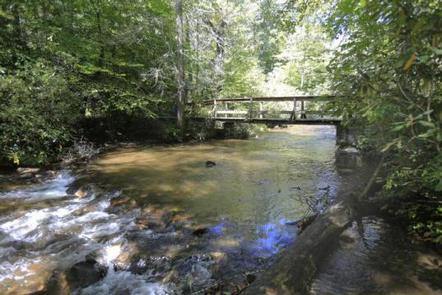
From the Asheville airport, take Highway 280 south to Brevard. Turn right on U.S. Highway 276. Go 1.75 miles to Forest Road 477 and turn right. Go 0.75-mile to the parking area on the right side of the road. Walk across the bridge to the campground entrance road.

Phone

828-552-8040

Activities

BIKING, CAMPING, INTERPRETIVE PROGRAMS, FISHING, HIKING, WATER SPORTS, SWIMMING SITE

Keywords

WHPS,SOUTH WHITE PINE GROUP CAMP,NFs IN NORTH CAROLINA – FS

Related Link(s)

Rec Area Info & Images

North Carolina State Road Conditions

North Carolina State Tourism

Overview

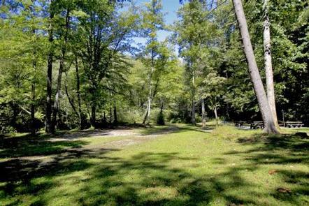
White Pine South Group Camp is one of two group campsites nestled along Avery Creek in the lush forests of the Appalachian Mountains. The facility provides tent camping year-round and can accommodate families, scout troops and other groups of up to 25 people.

Visitors have access to a number of recreation opportunities, including hiking, swimming, mountain biking, fishing and picnicking, in one of the most scenic areas in the state.

Recreation

The forest is known for its hiking and mountain biking trails, several of which are close to the campground. Avery Creek and the Davidson River offer great trout fishing. For visitors wishing to learn more about the area, interpretive programs may be available upon request.

Facilities

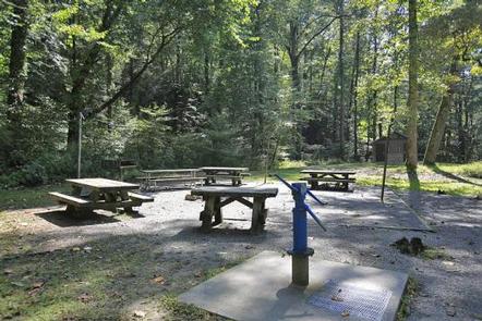
The site is equipped with picnic tables, vault toilets, lantern posts, campfire rings with grills and drinking water.

Natural Features

The campground lies in Pisgah National Forest at an elevation of 2,600 feet. The surrounding land boasts mile-high peaks, cascading waterfalls and slopes thickly forested with hardwoods. The group camping area is adjacent to Avery Creek and near the beautiful Davidson River.

Nearby Attractions

The city of Asheville is about an hour away and offers numerous cultural attractions, art galleries, shops and restaurants. The small town of Brevard is also nearby and has various amenities and services.

Reservation

More from CampingHiking.net:

Diamond Creek Guard Station, Idaho Campground Images, Info & Reservations

Directions From Soda Springs, take Highway 34 north approximately 12 miles to the China Hat turnoff (Blackfoot River Narrows). This road will follow Blackfoot River for another 11 miles to a junction; there is a Forest Service sign at this point. Take the right fork (Caribou National Forest Road 102)

SLY GUARD CABIN, California Campground Images, Info & Reservations

Directions Sly Guard Cabin is located off U.S. Highway 50 in Pollock Pines, approximately 16 miles east of Placerville. Take Exit 60 (Sly Park Road) and travel south approximately 6.2 miles. Arrive at 5561 Sly Park Road on the left. Phone 530-644-2324 Activities BOATING, HISTORIC & CULTURAL SITE, CAMPING, HIKING,

MAPLE GROVE, Utah Campground Images, Info & Reservations

Directions From Scipio, Utah, take U.S. 50 south. Turn west at Maple Grove Campground sign/Forest Road 101 at milepost 146. Travel 4 miles to the campground. Phone 435-743-5721 Activities CAMPING, HIKING Keywords MAPL,FISHLAKE NF – FS Related Link(s) Rec Area Info & Images Utah State Tourism Utah State Road Conditions

HEADQUARTERS, California Campground Images, Info & Reservations

Directions From Bakersfield, take Highway 178 East to Lake Isabella. From Lake Isabella, take Highway 155 around the west side of the lake to the town of Kernville. From Kernville, go 4 miles north on Sierra Way (Mountain 99) to the campground. Phone 760-376-1815 Activities BOATING, CAMPING Keywords HEAD,KERN RIVER,UPPER

LAKE HILL, Utah Campground Images, Info & Reservations

Directions Located approximately 5 miles east of Ephraim, Utah on Forest Highway 8 in Ephraim Canyon. Phone 435-283-4151 Activities BOATING, CAMPING, FISHING, HIKING Keywords LAKH,MANTI-LASAL NF -FS Related Link(s) Rec Area Info & Images Utah State Tourism Utah State Road Conditions Overview Lake Hill Campground is situated next to pretty

HANNA FLAT, California Campground Images, Info & Reservations

Directions Travel east on I10 (Highway 330) to Running Springs. Turn onto Highway 18 and continue to Big Bear Lake Dam but do not cross the dam. Highway 18 becomes Highway 38. Continue to the Fawnskin Fire Station and turn left onto Rim of the World Drive (Forest Route 3N14)