

Directions
From Baker City, Oregon, travel south on Highway 7 for about 18 miles. The campground and day-use entrance is on the left side of the road. Follow the signs in the Union Creek Recreation Area down to the various campground loops and areas.
Phone
541-894-2332
Activities
BIKING, BOATING, CAMPING, FISHING, HIKING, PICNICKING, WATER SPORTS, SWIMMING SITE, PHOTOGRAPHY, MOTOR BOAT, MOUNTAIN BIKING, PADDLE BOATING, KAYAKING, CANOEING, BIRDING, JET SKIING, WATER SKIING, SAILING
Keywords
NW02,Phillips Reservoir
Related Link(s)
Overview
One of Eastern Oregons largest Forest Service campgrounds, Union Creek Campground is located 18 miles South of Baker City. Sitting along Phillips Reservoirs North shore, Union Creek Campground boasts many amenities including over 60 tent/trailer sites, some with full hookups. There is access to boating, mountain biking, hiking and more.
This campground is part of the Union Creek Recreation Area, which includes a picnic and day-use area. Union Creek Campground is set on three loops with separate walk-in tent camping, and it has four group sites that can accommodate large groups up to 60 people.
PLEASE NOTE: This Union Creek Campground is located in northeastern Oregon in the Wallowa Whitman National Forest. This is not the Union Creek Campground located in southwestern Oregon near Medford.
Recreation
The campground is near a boat launch and a small, rocky swim beach. Activities include swimming, fishing, boating, and water skiing. Anglers can fish for bass, trout and perch. There’s an access point for the Phillips Lake Shoreline Trail, a scenic trail for hiking and mountain biking. This trail can be connected to make a 16 mile loop around the lake.
Facilities
The parking spurs are paved and gravel and large enough for any size RV. Several sites offer full hookups, and some others offer water and electric. Units are equipped with picnic tables and grills. Drinking water and flush toilets are available. Some of the facilities are handicap-accessible.
Natural Features
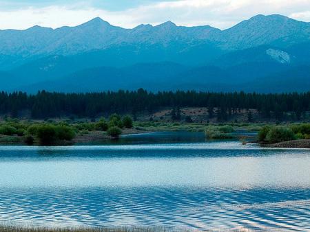
Phillips Reservoir is a popular destination within the Wallowa-Whitman National Forest because it offers scenic views of the surrounding Elkhorn Mountains. The shoreline is forested with a mix of Ponderosa pine and various firs interspersed with small grasslands. Visitors enjoy several varieties of colorful wildflowers in the spring.
Nearby Attractions
The historic gold mining town of Sumpter is about 10 miles away, West of Hwy 7. Visitors can explore the Sumpter Dredge State Heritage Park, browse the holiday weekend flea markets or take a ride on a historic steam locomotive.
Charges & Cancellations
A $10.00 service fee will apply if you change or cancel your reservation. Late cancellations are subject to additional fees. For full details see NRRS Reservation Policy