RAINBOW POINT CAMPGROUND, MONTANA Campground Reservation, Info, Images, Map, Directions

RAINBOW POINT CAMPGROUND, Montana Campground Images, Info & Reservations

Directions

From West Yellowstone, travel 5 miles north on Highway 191. Turn west (left) onto Rainbow Point Road (Forest Road 6954) and travel 3 miles, then 2 miles north (right) on Rainbow Point Road, after the intersection.

Phone

406-646-1012

Activities

BIKING, BOATING, CAMPING, FISHING, HIKING, WILDLIFE VIEWING, DAY USE AREA, PHOTOGRAPHY, SWIMMING, KAYAKING, CANOEING, BERRY PICKING, BIRDING, WATER ACCESS, BACKPACKING, MUSHROOM PICKING

Keywords

Hebgen Lake Campground,RAPC

Related Link(s)

Rec Area Info & Images

Forest Service Concessionaire

Montana State Road Conditions

Montana State Tourism

Overview

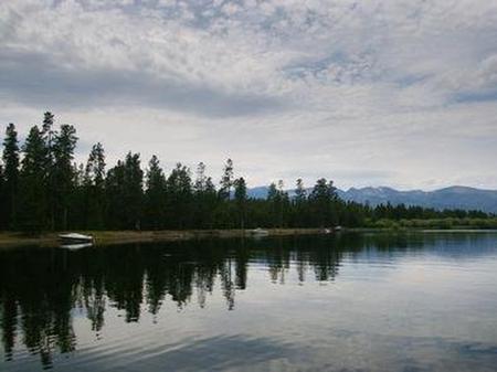
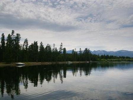
Rainbow Point Campground is located on the banks of scenic Hebgen Lake, in southwestern Montana. It is approximately 10 miles north of West Yellowstone and the West Entrance of Yellowstone National Park. Visitors enjoy the area for its boating, fishing and hiking opportunities, as well as its close proximity to Yellowstone.

Recreation

Hebgen Lake is considered Montana’s premier still-water fishing lake. Anglers will find a healthy population of brown, cutthroat and rainbow trout. Boating and swimming are popular activities on the lake. A boat ramp is located within the campground.

Hiking, biking and off-road vehicle trails crisscross the surrounding area.

Facilities

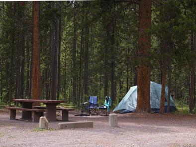
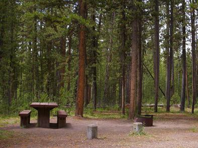
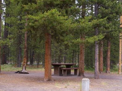
The campground offers several single-family campsites, many of which have electric hookups. Sites are equipped with a picnic table and campfire ring. Vault toilets and drinking water are provided. Firewood is available for purchase within the campground.

Natural Features

Hebgen Lake sits on the Madison River, at an elevation of 6,240 feet. The lake covers 21 square miles and has 65 miles of shoreline. Rainbow Point is situated on Rainbow Bay, among a dense forest of lodgepole pine.

A variety of waterfowl is often spotted in the area, including sandhill cranes, herons, Western grebes, white pelicans, osprey, Canada geese, mallards, wood ducks, loons and bald and golden eagles. Bison, deer and moose are frequently seen as well.

Nearby Attractions

West Yellowstone offers dining, shopping and lodging options. The Grizzly and Wolf Discovery Center is a popular attraction with live grizzlies, gray wolves and birds of prey, and a variety of educational exhibits and programs.

Yellowstone National Park offers unparalleled wildlife viewing opportunities, breathtaking scenery and unique geological features.

Reservation

More from CampingHiking.net:

JUMBO ROCKS CAMPGROUND, California Campground Images, Info & Reservations

Directions Take Interstate 10 to State Highway 62. Turn south on Park Blvd. Continue 5 miles to the West Entrance; Jumbo Rocks is approximately 18 miles from the entrance. If coming from the east, taking Interstate10, take the Desert Center exit north onto State Highway 177. Continue on State Highway

SHEEP PASS GROUP, California Campground Images, Info & Reservations

Directions Take Interstate 10 to Route 62. From the town of Joshua Tree turn south on Park Blvd. and continue through the West Entrance. The campground is 13 miles from the entrance station and the city of Twentynine Palms. Phone 760-367-5554 Activities CLIMBING, CAMPING, HIKING, PICNICKING Keywords CG40,Joshua Tree National

BRENTS BEACH CABIN, Alaska Campground Images, Info & Reservations

Directions Accessible year round, weather permitting. Located 15 miles west of Sitka on the southeast shore of Kruzof Island. Access is 30 minutes by boat from Sitka. Helicopter landing on the beach is possible at lower tides. Refer to USGS topographic maps Sitka A-5, A-6. Boat access can only occur

JOHN W. FLANNAGAN DAY USE, Virginia Campground Images, Info & Reservations

Directions From VA-63, turn right onto State Route 614. Continue straight for approximately two miles. Phone 276-835-9544 Activities BOATING, CAMPING, FISHING Keywords JOHW,John W. Flannagan Dam,Spillway- Shelters 2 and 3,Below dam recreation area,The two smaller shelters below,JOHN W FLANNAGAN DAY USE,JOHN W FLANNAGAN DAM Related Link(s) Rec Area Info &

COTTONWOOD CAMPGROUND (WA), Washington Campground Images, Info & Reservations

Directions From Naches, take Highway 410 northeast 22.5 miles to milepost 99.5. Phone 541-338-7869 Activities CAMPING, FISHING, HIKING, WATER SPORTS Keywords CTWD,OKANOGAN – WENATCHEE NF -FS,COTTONWOOD,COTTONWOOD CAMPGROUND Related Link(s) Rec Area Info & Images Washington State Tourism Washington State Road Conditions Forest Service Concessionaire Overview Cottonwood Campground is located along