

Directions
Total mileage from Lowell to Timber Butte Cabin is 19 miles.
From Interstate 5 (I-5), take Highway 58 East (Exit 188) and travel for 13 miles toward Oakridge. Turn left off of Highway 58 at the Lowell covered bridge and proceed toward the town of Lowell. At the 4-way junction in Lowell, turn left onto Boundary Road. Take the next right (Moss Street) for 2 miles to the crossroads of Unity, where you’ll see another covered bridge. Turn right (east) onto Big Fall Creek Road (18) and proceed to MP 13 and turn right onto Forest Service Road 1821, continue up approx. 4 miles. Turn right onto FSR 1821-168 and proceed 1 mile. Turn right onto FSR 1816-175 and after 100 yards turn left onto FSR 1816-131 (gated entrance road to the cabin).
Cabin parking is located about 1 mile up FSR 1816131, adjacent to the outhouse. A high-clearance vehicle is recommended.
Phone
541-782-2283
Activities
CAMPING, HUNTING, WILDLIFE VIEWING, BIRDING
Keywords
TBCA,Timber Butte Lookout
Related Link(s)
Overview
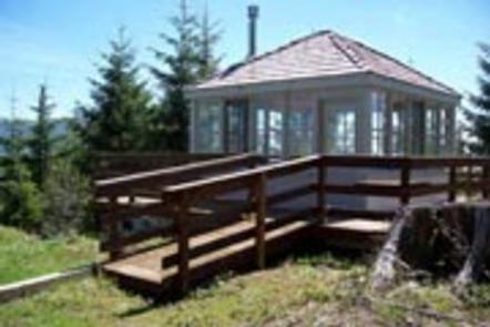
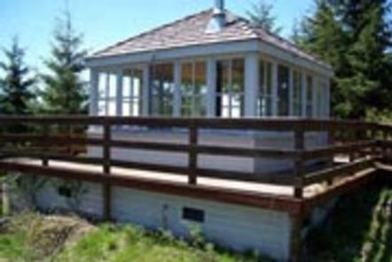
Timber Butte Lookout is located in the Fall Creek area of the Willamette National Forest at an elevation of 3,650 feet 19 miles from Lowell, Oregon. The cabin is open from mid-April through late October, offering the chance to enjoy beautiful scenery and a variety of recreational activities. The lookout was constructed in 2005 as a replica of the L-4 gabled-style lookout with wooden catwalk commonly built in this region in the 1930s. It was built through volunteer efforts with a $10,000 grant from Lane County and other contributions by individuals and organizations. The cabin can be accessed by car, but guests should expect to walk about 300 feet uphill from their parking spot. A high-clearance vehicle is recommended.
Recreation
The lookout is located near the Fall Creek Trail Area. Several hiking trails can be accessed from this area, including the Fall Creek National Recreation Trail, which also offers opportunities for fishing and picnicking. Swimming holes can also be found along this trail.
Hunting is another popular activity in this area.
Facilities
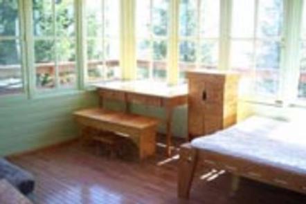
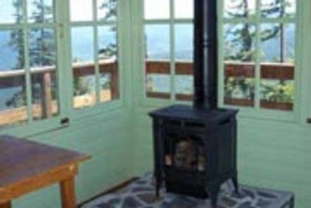
The 14×14-ft. cabin is encircled by a catwalk. It sits slightly off the ground and is accessed by a ramp. The cabin accommodates 4 people and contains a double bed with sleeping pad, a propane heating stove, fire extinguisher, broom and dustpan. A 3-burner propane cook top is located on the deck. Propane is provided. Dishes and cookware are available. A picnic table and fire ring are located in a nearby group of trees, and a vault toilet is located about 300 feet away. No drinking water or electricity is provided. Guests must bring their own supply of drinking water. Items such as bedding, lanterns or flashlights, matches, extra toilet paper, first aid supplies, trash bags, dish soap, towels and an ice chest are not available. Guests are expected to pack out their trash and clean the cabin before leaving.
Natural Features
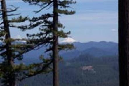
The lookout offers panoramic views of the Cascade Mountains and the surrounding evergreen forest. On clear days, guests may see Mount Jefferson and the peaks of the Three Sisters. Willamette National Forest offers prime habitat for such species as Roosevelt elk, black bear, bald eagles, black tail deer and bobcats, among other wildlife.
Nearby Attractions
Guests can explore up to 20 historic covered bridges in nearby Lane County by car. Within 10 miles there is creek access, fishing, swimming, and hiking.