Directions
There is a combination lock on the shower unit. This will give you access to the Cabin’s key. To obtain the current lock combination, call the Ranger Station (Monday-Friday) 48 hours prior to your arrival at (509) 784-4700. Have your reservation number available when you call. Cottonwood Cabin is accessible by car. Please contact the Ranger District at (509) 784-4700 prior to arrival for current restrictions or conditions, such as fire or road closures, weather or storms that may affect the quality of your visit. From north Seattle/Everett take US-2 to Wenatchee. From south Seattle/Tacoma take I-90 to exit 85 and then WA-970, US-97 and US-2 to Wenatchee. From Wenatchee, WA , at the junction of US Highway 2 and Washington State Route 97A, take State Route 97A and travel north 17 miles along the west bank of the Columbia River. Turn left 100 yards north of the Entiat River Bridge on to Entiat Valley Road (Chelan County Route 19). Continue west/northwest 24 miles to the Wenatchee National Forest boundary. Continue on Entiat Valley Road (which becomes Forest Road 51) to the end of the pavement (mile post 34), where you will see North Fork Campground on the left. Continue past North Fork Campground to mile post 38 where you will see Cottonwood Cabin on the left. From Chelan, WA , travel south on US-97A (west side of Columbia River) for 19.3 miles to Entiat, WA. Just before the bridge turn right on to Entiat River Road (County Road #19) a. Continue west/northwest 24 miles to the Wenatchee National Forest boundary. Continue on Entiat Valley Road (which becomes Forest Road 51) to the end of the pavement (mile post 34), where you will see North Fork. Drive past North Fork Campground to mile post 38 where you will see Cottonwood Cabin on the left.
Phone
(509)784-4700
Activities
CAMPING, FISHING, HIKING, HORSEBACK RIDING, HUNTING, WILDLIFE VIEWING, MOUNTAIN BIKING
Keywords
CCAB,Cottonwood Guard Station
Related Link(s)
Washington State Road Conditions
Overview
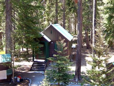
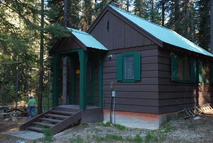
Cottonwood Cabin is located in the Okanogan-Wenatchee National Forest, Entiat Ranger District in central Washington’s Entiat Valley, on the banks of the Entiat River at an elevation of 3,100 feet. Constructed in the 1940s as administrative housing, the facility and on-site barn and corral were used seasonally by Forest Service fire, trail and campground crew personnel.
Today the cabin offers visitors a wonderful setting for recreation and relaxation from June through October in the forested mountain terrain of the Entiat Ranger District. The cabin can be reached by standard passenger vehicles over gravel roads.
Recreation
Guests at Cottonwood Cabin will find that the surrounding area offers opportunities to hike, fish, mountain bike and enjoy a long list of outdoor recreational activities throughout the year.
Anglers will enjoy casting a line into the Entiat River above Entiat Falls. The cabin is located four miles above the falls. Carving through a wide, U-shaped valley, the river is dominated by relatively shallow riffles interspersed with pools, plunge pools and glides where the trout fishing is quite good. Populations of rainbow trout, Cutthroat trout, and Eastern brook trout are found in this tributary. Selective gear rules apply to fishing in the Entiat River. See Washington Department of Fish and Wildlife for fishing rules and regulations.
Facilities
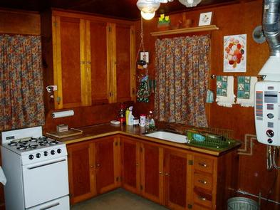
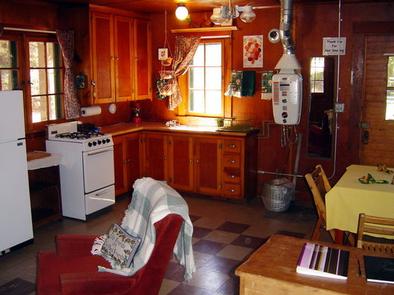
The one room cabin (20′ x 16′) can accommodate four people at a time. Amenities include hot and cold running water (summer months only), propane cook stove, wall heater, refrigerator, and LED lights.
Furnishings include a dining table, lounge chair, futon sofa that coverts to a double bed, and a separate double bed. The small kitchen area is supplied with basic pots, pans, silverware and plates.
Outdoors, a private shower facility, picnic table, campfire ring and pit toilet are provided. An area for pitching one tent is also on site. Wood may be available, but the supply cannot be guaranteed.
Guests must bring several of their own amenities as the cabin does not provide food, sleeping bags/bedding, towels, dish soap, matches, a first aid kit, toilet paper or garbage bags.
The light system is solar powered. Although lighting is provided, visitors are encouraged to bring additional light sources. Cabin water is provided by pressurized solar water for summer months.
Natural Features
The Okanogan-Wenatchee National Forest offers stunning scenic vistas, with high, glaciated alpine peaks, valleys of old growth forest and rugged shrub-steppe country making up the diverse landscape. Elevations range from below 1,000 feet to more than 9,000 feet. The surrounding forest provides excellent habitat for a wide range of wildlife. Precipitation varies greatly throughout the area, ranging from approximately 140 inches along the Cascade Crest to only 10 inches along the eastern edge. Visitors can expect many days of warm, sunny weather in the summer, and winters with clear skies and plenty of snow.
Nestled in a mature lodge pole pine and spruce forest, the area surrounding the cabin is home to abundant wildlife, including mule deer, cougars, native fish, black bears, pine marten, moose, bald and golden eagles and a variety of woodpeckers and owls.
Nearby Attractions
The Silver Falls National Recreation Trail is a 1.8 mile hike beneath towering cedar and pines, along Silver Creek to the base of Silver Falls. Along the way, hikers are treated to views of the 141-foot cascade, as well as the Entiat valley below, and the mountains above. Beautiful stone staircases and bridges along the trail offer many stopping points to take the perfect photograph.
At Entiat River Road mile marker 27.8 is Box Canyon. This geological formation is about 65 million years in the making and the chasm spans a run of about 500 feet and ranges from 75-150 ft. deep. Fish Tail Falls can be observed from the view point running over, under and through a pile of large boulders, cascading another 15 feet. At times you can see salmon in this pool.
At mile marker 32.2 on Entiat River Road is Entiat Falls. This broad 25 foot cascading natural waterfall makes quite a rejuvenating impression. Bring a picnic lunch or just stretch your legs and enjoy. Take precaution as river rock can be very slick.
Cooper’s Store and Cafe in Ardenvoir is approximately 28 miles down valley and is the nearest source of gasoline, groceries, miscellaneous camping supplies and telephone services.


