CHILDS GLACIER RECREATION AREA, AK Campground Reservation, Info, Images, Map, Directions

CHILDS GLACIER RECREATION AREA, Alaska Campground Images, Info & Reservations

Directions

From Cordova, the campground is 48 miles east on the Copper River Highway. The campground is just before the Million Dollar Bridge. A section of the highway at mile 36 washed out requiring a short boat ride to the other side. Several companies provide a ferry service and transportation to the campground.

Phone

907-424-7661

Activities

CAMPING, HIKING, WILDLIFE VIEWING

Keywords

CGRA,child’s,childs glacier

Related Link(s)

Rec Area Info & Images

Alaska State Road Conditions

Alaska State Tourism

Overview

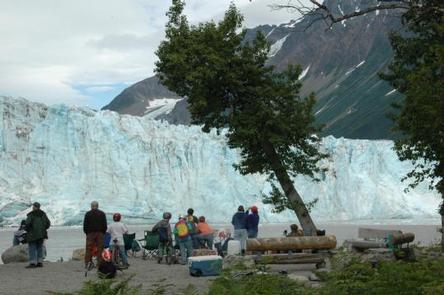
When visitors camp at Childs Glacier Recreation Area, they’re instantly captivated by spectacular views of Childs Glacier, which is famous for it’s calving icebergs that put on a great show. Other must-do activities in the area include hiking along the river and fishing for salmon. Childs Glacier is the only glacier reached by road where visitors can see calving occurring. When icebergs fall from the glacier, they are sometimes so large that they send a 10-foot wave rippling across the river to the opposite shore.

Recreation

The Copper River boasts plenty of salmon. Wildlife watching opportunities include moose and both grizzly and black bears. Lucky campers may spot bears fishing on the opposite side of the river.

Recommended trails include Copper River and Miles Lake. Copper River Trail is rather flat and marshy, with dense vegetation. Stellar waterfowl watching abounds on this hike.

Facilities

The campground is suited for tent camping. Picnic tables, vault toilets, and interpretive trails are available. Drinking water is from hand pumps.

Natural Features

The recreation area is nestled in the Chugach Mountains on the south coast of Alaska. Many campsites boast views of the mountains and the top of Childs Glacier. Alder willow, devil’s club and fern make up much of the campground understory. Tall cottonwoods dominate overhead. The campground is about 300 feet from the Copper River, which is wide, shallow and glacier fed.

Nearby Attractions

The historic Million Dollar Bridge, constructed in 1910, is nearby. The bridge over the Copper River was used to transport copper from the old mining town of Kennicott to the port of Cordova.

Reservation

More from CampingHiking.net:

RUJADA CAMPGROUND, Oregon Campground Images, Info & Reservations

Directions From Cottage Grove, take exit 174 on Interstate 5, then take Row River Road #2400 east 19 miles to Layng Creek Road #17. Turn left (northeast) on Road #17 and continue for 2 miles until you reach Rujada Campground, located on the right, across Layng Creek. Phone 541-767-5000 Activities

PINECREST, California Campground Images, Info & Reservations

Directions From Sonora, take Highway 108 east for 30 miles, take the Pinecrest exit onto Pinecrest Lake Road and continue to the campground. Phone 209-965-3116 Activities BIKING, BOATING, CAMPING, FISHING, HIKING, HORSEBACK RIDING, DAY USE AREA, SWIMMING SITE Keywords PINC,PINECREST CAMPGROUND,STRAWBERRY CAMPGROUND,STANISLAUS NF -FS Related Link(s) Rec Area Info &

CARDEN POINT, Arkansas Campground Images, Info & Reservations

Directions From Plainview, Arkansas, take Route 60 east for 5.5 miles to the Access Road, then follow signs into campground. Phone 479-272-4324 Activities BOATING, CAMPING, FISHING, SWIMMING Keywords Garden Point Related Link(s) Rec Area Info & Images Arkansas State Tourism Arkansas State Road Conditions Overview Carden Point Day Use Park

SOUTH SANDUSKY CAMPGROUND, Illinois Campground Images, Info & Reservations

Directions From I-57 take exit 71 and turn west onto Route 14. After 3 miles turn right on Rend City Road, then continue for 6 miles to the campground entrance on the right. Phone 618-724-2493 Activities BIKING, CAMPING, INTERPRETIVE PROGRAMS, FISHING, HIKING, WILDLIFE VIEWING, SWIMMING SITE, STAR GAZING Keywords SSAN,REND

FORKS OF HUNTINGTON, Utah Campground Images, Info & Reservations

Directions The campground is 16 miles west of Huntington, Utah, along Highway 31. Phone (435)384-2372 Activities BIKING, CLIMBING, CAMPING, FISHING, HIKING, WILDLIFE VIEWING Keywords FORH,MANTI-LASAL NF -FS Related Link(s) Rec Area Info & Images Utah State Tourism Utah State Road Conditions Overview Forks of Huntington Campground is located in beautiful