
Directions
The cabin is approximately 48 miles northeast of the community of Pierce, Idaho. The last 31 miles to the cabin from Pierce are narrow, have a gravel surface and may be peppered with large potholes and rocks, so travel can be slow-going. Kelly Forks Cabin is also situated about 54 miles southwest of Superior, Montana consisting mostly of gravel surface that can be rough and partially blocked. Visitors are advised to consult a map, and the forest web site in advance of making reservations as well as prior to travel, to plan their trip accordingly.
From Lewiston, Idaho: Travel 45 miles west on U.S. Highway 12 to the bridge at Orofino, Idaho. Cross the bridge – don’t deviate; you will travel on Michigan Avenue and then Grangemont Road, aka State Highway 7- and continue 30 miles north to the former Jaype Mill site. Turn right and continue 6 miles to the town of Pierce, Idaho. Drive through Pierce (approximately 3/4 mile) and turn left on French Mountain Road, also known as Forest Road 250. Remain on FR 250 for 48 miles until you reach the Kelly Forks Work Center.
From Superior, Montana: Travel 25 miles west on Forest Road 250, also known as the Trout Creek Road. You will cross the Hoodoo Pass at the Idaho-Montana stateline. Continue south on FR 250 for approximately 29 more miles until you reach the Kelly Forks Work Center. *NOTE: Hoodoo Pass rises to 6,000-ft elevation and is typically impassable due to snow from November until early July. This pass is not plowed and alternative access may be necessary until the snowpack melts through.
From Missoula, Montana: Travel 173 miles west on U.S. Highway 12 to the bridge at Orofino, Idaho. Cross the bridge – don’t deviate; you will travel on Michigan Avenue and then the Grangemont Road, aka State Highway 7- and continue 30 miles north to the former Jaype Mill site. Turn right and continue 6 miles to the town of Pierce, Idaho. Drive through Pierce (approximately 3/4 mile) and turn left on French Mountain Road, also known as Forest Road 250. Remain on FR 250 for 48 miles until you reach the Kelly Forks Work Center.
Phone
208-476-4541
Activities
BIKING, CLIMBING, HISTORIC & CULTURAL SITE, CAMPING, FISHING, HIKING, HORSEBACK RIDING, HUNTING, PICNICKING, VISITOR CENTER, WATER SPORTS, WILDLIFE VIEWING, INFORMATION SITE, PHOTOGRAPHY, SWIMMING, MOUNTAIN BIKING, RANGER STATION, KAYAKING, BERRY PICKING, STAR GAZING, BIRDING, WATER ACCESS, SCENIC DRIVE, RAFTING, BACKPACKING, MUSHROOM PICKING, TUBING, OFF HIGHWAY VEHICLE TRAILS
Keywords
KFKC,Kelly Cabin
Related Link(s)
Overview
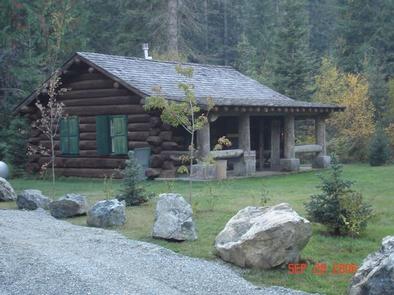
Kelly Forks cabin is located in a small clearing within an active forest service work center. It was originally built at the confluence of Moose and Kelly Creek during the mid 1930s to be used as a stopover between the upper North Fork and the Bungalow ranger station. It was then dismantled to be floated down Kelly Cr and reassembled at its current location during the mid 1900s. Fully remodeled around 2002 with modern comforts, the cabin maintains a high demand throughout the rental season. Although assessable by car, the gravel roads on the district can be quite rough and partially blocked with debris. Visitors are strongly advised to consult a map as well as the forest website, prior to reserving or traveling to the cabin.
Recreation
There are several fishing holes and hiking trails located within easy walking distance of the cabin, with many more a short drive in any direction. The North Fork ranger district prides itself on the diversity of world class recreational opportunities ranging from bird/wildlife watching, big game hunting, whitewater rafting, leisurely floats, secluded backpacking/equestrian trails into the high mountain backcountry, to motorized OHV/ ATV/OHV trail systems, providing unique experiences that draws visitors from around the world of all walks of life. Be sure to check the regulations and rules to educate yourself before you recreate by visiting https://idfg.idaho.gov/ and https://www.fs.usda.gov/news/nezperceclearwater/news-events for up to date information.
Facilities
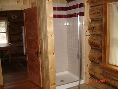
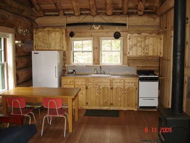
The 3 room cabin can accommodate up to six people and is furnished with electricity, lights, running water, on demand propane hot water, individual electric radiant heaters for each room. The bedroom contains 1 twin and 1 full size mattresses, and a dresser w/mirror. The spacious bathroom is equipped with a shower stall, flush toilet. sink and mirror. The kitchen is equipped with an electric range w/oven, microwave, refrigerator/ freezer, sink, drip coffee pot, toaster with an odd assortment of pots, pans, plates, bowls, utensils, silverware, cups, glasses and the vaulted living area provides 2 full sized futons, and table with 4 chairs. The cabin also has a large covered porch with camp chairs and a picnic area that has a table and fire ring (guests provide their own fire wood). The cabin can be reserved for a single night or up to 6 consecutive nights by the same individual or group. Guests are required to bring their own bedding, pick up after their pets and clean the cabin before they check out with the provided cleaning supplies, under the leave it cleaner than when you arrived policy.
Natural Features
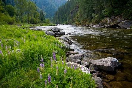
The cabin is situated in a small, semi secluded clearing surrounded by evergreens, cottonwood, alder mixed with huckleberries at the confluence of Kelly Creek and the North Fork of the Clearwater River. The area is known worldwide as a blue ribbon fishery for West Slope Cutthroat Trout, and the beautiful crystal clear waters are just a stone’s throw from the cabin. A wide variety of wildlife including elk, white-tailed and mule deer, black bear, wolf, cougar, bobcat, mountain goat, moose, eagle, otter, marten, fisher, osprey, raven, king fisher, dippers and many more call the steep, densely vegetated river valleys home. Seasonal changes can be particularly enjoyable from the swift moving whitewater in the spring to the extraordinary fall colors pursued by the crisp white snow line.