KIMBALL BEND PARK, TX Campground Reservation, Info, Images, Map, Directions

KIMBALL BEND PARK, Texas Campground Images, Info & Reservations

Directions

From Kopperl, TX, travel north on HWY 56 for approximately 2.5 miles. Turn right on HWY 174 and go approximately 2.3 miles. Turn left into the park, just before the HWY 174 bridge.

From Cleburne, TX, travel south on HWY 174 for 22 miles. Turn right into the park after you cross the HWY 174 bridge.

Phone

254-622-3332

Activities

BOATING, HISTORIC & CULTURAL SITE, CAMPING, FISHING, HIKING, WATER SPORTS, WILDLIFE VIEWING, SWIMMING SITE

Keywords

KIBE,Kimball Bend,Kimball,Kimbell,Whitney Lake

Related Link(s)

Rec Area Info & Images

Texas State Tourism

Texas State Road Conditions

Overview

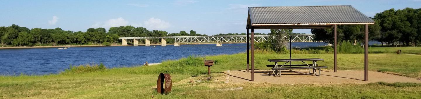
Kimball Bend Campground is located on Whitney Lake off the main channel of the Brazos River in Central Texas. The campground offers 34 50 amp campsites.

Recreation

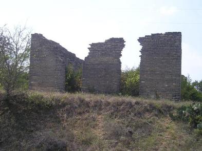
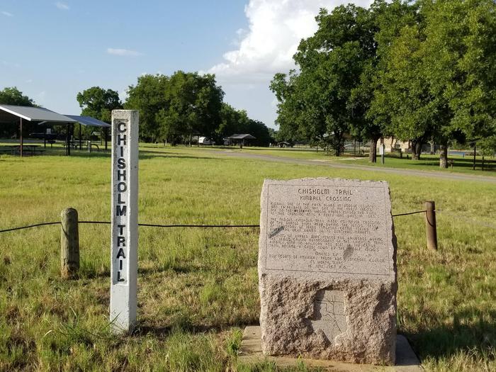
Boating, fishing, swimming, canoeing and kayaking are popular activities on the river and downstream at Whitney Lake. Anglers can fish for a variety of bass, crappie and catfish. Visitors enjoy hiking the Chisholm Trail, a historic route followed by upwards of ten million cattle as they traveled northbound from southern Texas to Kansas and adjacent destinations between 1867 and the 1880s. It crosses through the campground and past several historic structures.

Facilities

This year-round campground offers 34 sites with water and electric hookups. Amenities include flush toilets, showers, drinking water, a dump station and boat ramp.

Natural Features

The Brazos River flows gently over sand and rocks at Kimball Bend. The surrounding rolling hills are covered with cedar, live and post oak.

Nearby Attractions

The 12.5 mile Hopewell Trail is nearby. It allows hiking, mountain biking, and horseback riding. Visitors can travel south to Lakeside Village and Powelldale Mountain.

Reservation

More from CampingHiking.net:

CONEROSS PARK, Georgia Campground Images, Info & Reservations

Directions From Interstate 85 in South Carolina, take Exit 11 onto Highway 24 towards Townville. About 1.5 miles past Townville, turn right onto Coneross Creek Road. Follow signs to the park entrance. 699 CONEROSS PARK ROAD, Townville, SC 29689 Phone 888-893-0678 (HARTWELL PROJECT OFFICE) Activities BOATING, CAMPING, FISHING, SWIMMING SITE,

PEACEFUL VALLEY, Colorado Campground Images, Info & Reservations

Directions From Denver, go north on Interstate 25 to U.S. Highway 36 west. Continue on U.S. 36 through Boulder to Lyons. Take Colorado Highway 7 and go approximately 12 miles, then Colorado Highway 72 for approximately 4 miles. Phone 303-541-2500 Activities BIKING, CAMPING, FISHING, HIKING, HORSEBACK RIDING Keywords PEAC,ARAPAHO AND

WOODRING CAMPGROUND, Georgia Campground Images, Info & Reservations

Directions From Atlanta, take I-75 north to Exit 293; follow Highway 411 north. Turn right on Highway 136, then left on old Highway 411. Turn right on Highway 282/76. Campground is located 4.5 miles off Highway 282. From Ellijay, GA, take Highway 282/76 west for 11 miles to the access

LOGGER CAMPGROUND, California Campground Images, Info & Reservations

Directions From Truckee, Calif., travel east on Interstate 80 for 10 miles, to the Hirschdale Road exit. Follow Hirschdale Road/Stampede Dam Road north for eight miles, to the Stampede Reservoir. Take a left on Dog Valley Road to go over Stampede Dam. Go past Emigrant Group Campground and in a

MILL HOLLOW, Utah Campground Images, Info & Reservations

Directions From Woodland, Utah, travel 12 miles southeast on State Highway 35. Turn onto Forest Road 054 and travel 2.8 miles to the campground entrance. Phone HEBER RANGER DISTRICT 435-654-0470 OR UTAH RECREATION COMPANY 385-273-1100 Activities BOATING, CAMPING, FISHING, HIKING, WILDLIFE VIEWING Keywords MILH,UINTA NF – FS Related Link(s) Rec