Directions
From Hungry Horse, drive east on Highway 2 to Martin City, then south on Forest Road 38. Drive about 55 miles on a winding, gravel road, along Hungry Horse Reservoir. At the junction with Diamond R Guest Ranch, turn east on Forest Road 568 and travel approximately 15 miles. Park at the trailhead and hike or ride on Trail No. 228 for about a third of a mile, to the Spotted Bear River Trail 83. Go past trails 43 and 89. Silvertip Cabin is just south of the Trail 89 intersection.
If traveling in July or August, the trail requires a 1.5-mile hike to the cabin. If traveling in June or September, a gate will prohibit access on Forest Road 568 and the trek to the cabin may be up to 4 miles.
Phone
406-758-5376
Activities
CAMPING, FISHING, HIKING, WILDLIFE VIEWING
Keywords
STCB,Silvertip,Silvertip Cabin,SILVERTIP CABIN (MT)
Related Link(s)
Overview
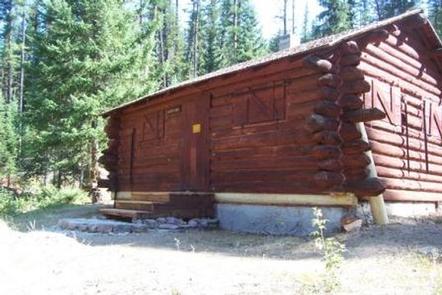
The remote Silvertip Cabin serves as an ideal base for accessing various hiking and horseback riding trails to the Great Bear and Bob Marshall Wilderness areas. Located 70 miles south of the town of Hungry Horse, up to eight guests can enjoy the comforts of the cabin’s mattress-covered beds and warm up by the wood stove following various wilderness adventures.
The cabin is only available on weekends from early July until August, or sometimes the first weekend of September. Access requires up to a 4-mile hike or horseback ride to the cabin, depending on conditions and the time of year. Guests are responsible for their own travel arrangements and safety, and must bring several of their own amenities.
Recreation
From the cabin, several hiking and horseback riding trails lead into the two wilderness areas. Fishing, wildlife viewing and hunting are also popular activities.
Facilities
The log cabin can sleep up to eight people in six single beds and two cots. Amenities include a propane stove, propane lights, basic cooking utensils, a wood stove, a sink with running water, and an outdoor pit toilet. Equestrian campers are welcome to use the corral and hitching rail. There is a water valve above the stock tank to provide water for the horses.
No tables or campfire rings are available outside the cabin. Drinking water is available at the cabin. The water system is not filtered but can be treated or boiled prior to consumption. There is a bag water filter for cabin use hanging next to the sink.
Guests should bring water, food, bedding, towels, a first aid kit and all other basic camp gear. Click here for more cabin details. Guests must clean the cabin and carry out all trash before leaving.
Dogs are allowed.
Natural Features
The cabin is situated in a stand of mixed conifer trees, at an elevation of 4,400 feet. It lies a short walk from the Spotted River, on a stretch of Flathead National Forest land wedged between Great Bear Wilderness to the north and Bob Marshall Wilderness to the west. Peaks in the region include Sergeant Mountain and Whitcomb Peak.
Nearby Attractions
Silvertip is a long distance from any modern conveniences. Guests should expect to drive over two hours for gas and groceries.

