Little Lava Lake, OR Campground Reservation, Info, Images, Map, Directions

Little Lava Lake, Oregon Campground Images, Info & Reservations

Directions

From Bend, travel 38.4 miles southwest on Cascade Lakes Hwy (46), then 0.7 miles east on Forest Road 4600 500, and then 0.4 miles east on Forest Road 4600 520.

Phone

541-323-1746

Activities

CAMPING, FISHING

Keywords

LILA,Lava Lake,Lava,Little Lava

Related Link(s)

Rec Area Info & Images

Forest Service Concessionaire

Oregon State Tourism

Oregon State Road Conditions

Overview

Little Lava Lake Campground is located along the Cascade Lakes National Scenic Byway in the Central Oregon Cascades.

Recreation

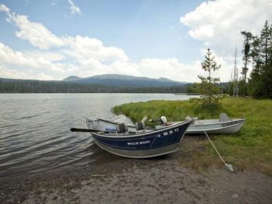
Little Lava Lake Campground provides recreation opportunities for fishing, paddling, swimming and hiking. For anglers, the 130-acre Little Lava Lake offers a quiet alternative to its larger neighbor to the north, Lava Lake. Reaching a maximum depth of 20 feet, the lake supports planted Rainbow trout, some Brook trout, and self-sustaining populations of Whitefish and Tui Chub. Bait, lures, flies, still fishing and trolling are all acceptable angling methods.

Facilities

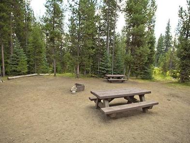
Little Lava Lake Campground’s campsites are predominately located under lodgepole pine canopy with some sites located along the lakeshore and the Deschutes River.

There is a boat ramp and a day use area that can be used at Little Lava Lake for a fee.

Natural Features

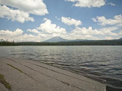
Little Lava Lake is located on the eastern slopes of the Cascade Mountain Range at an elevation of 4,740 feet. The small lake is surrounded by mature pine forests with bull rushes and lava outcroppings lining its shores. 

Nearby Attractions

Visitors can explore wilderness areas, wild and scenic rivers, lakes and reservoirs and approximately 1,600 miles of trails within the Deschutes National Forest.

Lava Lands Visitor Center in nearby Bend, Oregon, and the unique geological landscape of Newberry National Volcanic Monument draw visitors to the region as well.

Visitors will also enjoy traveling the Cascade Lakes Scenic Byway which climbs into the Cascades over a 66-mile drive through snow-capped peaks and alongside alpine lakes.

A nearby resort on Lava Lake offers lodging and a limited selection of groceries.

Reservation

More from CampingHiking.net:

WILDWOOD RECREATION SITE, Oregon Campground Images, Info & Reservations

Directions Wildwood Recreation Site is located 39 miles east of Portland on Highway 26 near Welches, Oregon. Phone 503-622-3696 Activities BIKING, HISTORIC & CULTURAL SITE, FISHING, HIKING, PICNICKING, WILDLIFE VIEWING, FISH VIEWING SITE, DAY USE AREA, ENVIRONMENTAL EDUCATION, PHOTOGRAPHY, MOUNTAIN BIKING, BERRY PICKING, BIRDING, WATER ACCESS, BACKPACKING Keywords WIWO,Wildwood Recreation

MOGOLLON CAMPGROUND, Arizona Campground Images, Info & Reservations

Directions Located on Road 300 approximately 5 miles off of Highway 260. Phone 928-535-9859 Activities CAMPING, INTERPRETIVE PROGRAMS Keywords Related Link(s) Rec Area Info & Images Arizona State Road Conditions Arizona State Tourism Overview Mogollon Campground, although not directly in the Woods Canyon Recreation area, sits just outside and is

BISHOP PARK GROUP, California Campground Images, Info & Reservations

Directions From Highway 395 in the center of Bishop, turn west on Line Street (Highway 168) west and drive 15 miles to the campground on the left. Phone 760-935-4339 Activities CAMPING, FISHING, HIKING, HORSEBACK RIDING, WILDLIFE VIEWING Keywords BISH,INYO NF – FS Related Link(s) Rec Area Info & Images California

THIBAUT POINT, Missouri Campground Images, Info & Reservations

Directions From Highway 65, take Highway T west for 3 miles. Turn south on Georgetown Ave and follow for a mile, following signs into the park. Phone 660-428-2470 Activities BOATING, CAMPING, FISHING, FISH HATCHERY, SWIMMING SITE Keywords THIB,TRUMAN LAKE,TEBO,HARRY S TRUMAN Related Link(s) Rec Area Info & Images Missouri State

CABIN CREEK CAMPGROUND, Montana Campground Images, Info & Reservations

Directions From West Yellowstone, travel 8 miles north on Highway 191, then 14 miles west on Highway 287. Phone 406-646-1012 Activities BIKING, CAMPING, FISHING, HIKING, HUNTING, WILDLIFE VIEWING, PHOTOGRAPHY, MOUNTAIN BIKING, BERRY PICKING, STAR GAZING, BIRDING, WATER ACCESS, BACKPACKING, MUSHROOM PICKING Keywords None Related Link(s) Rec Area Info & Images

LOST BRIDGE NORTH, Arkansas Campground Images, Info & Reservations

Directions From Rogers, Arkansas, take Highway 62 east for about 13 miles to Garfield. Turn right on Highway 127 and continue for 6 miles. Turn left on Marina Road and follow signs to the park. Phone 479-359-3312 Activities BOATING, CAMPING, HIKING, WATER SPORTS, SWIMMING SITE Keywords LOST,BEAVER LAKE,NORTH PARK,BEAVER LAKE