FIR COVE CAMPGROUND, CA Campground Reservation, Info, Images, Map, Directions

FIR COVE CAMPGROUND, California Campground Images, Info & Reservations

Directions

When traveling north on Highway 101, do not turn off at the Zenia Road exit at Garberville. This will result in a 2-hour delay driving on winding back roads. Instead, continue north until you reach the Hwy 36 exit near Fortuna. Turn right, heading east for approximately an hour until you reach the town of Mad River. After you cross the bridge at the Mad River, look for the Mad River Road turn-off on the right. The sign will say Ruth Lake. Continue for 20 minutes to reach Fir Cove campground.

If traveling on Interstate 5, turn at Hwy 36 at Red Bluff and head west for 2 hours until you see the sign for Ruth Lake at Mad River Road.

Phone

707-574-6233

Activities

BOATING, CAMPING, FISHING, HIKING, WATER SPORTS, WILDLIFE VIEWING

Keywords

FIR COVE CAMPGROUND (CA),Fir Cove Campground,Fir Cove,SIX RIVERS NF -FS

Related Link(s)

Rec Area Info & Images

California State Road Conditions

California State Tourism

Overview

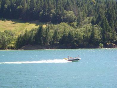
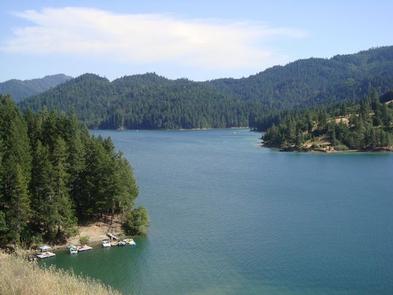
Fir Cove Campground is located on beautiful Ruth Lake, a 13,800-acre jewel situated in the thickly forested mountains of northern California. A variety of recreational opportunities abound.

It is one of three campgrounds in the region, and one of two on the lake. Bailey Canyon Campground is the companion to Fir Cove. It is located east of Fir Cove and is first-come, first-serve.

Recreation

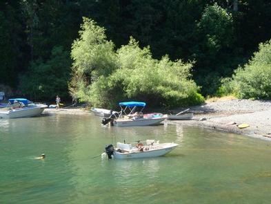
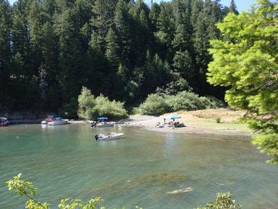
The lake provides boating, water skiing, fishing and countless other recreation opportunities.

Anglers can enjoy a catch of small and largemouth bass, catfish, rainbow trout, Kokonee salmon, bluegill and crappie.

Forested peaks and valleys offer ample opportunities for hunting, hiking and off-road vehicle use. The Bailey Vista and Lakeview Trailheads start from Fir Cove, and the Picket Peak Trailhead starts from Bailey Canyon.

Facilities

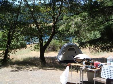
The campground offers several tent-only and multiple combined sites, many of them overlooking the lake. All sites are within a short walk from Ruth Lake. Sites 11 and 12 are companion sites.

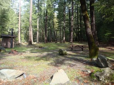
Tables and campfire rings with grills are provided, as well as accessible vault toilets and drinking water.

Natural Features

The campground straddles a seasonal creek that empties into Ruth Lake. It is nestled in a mixture of mature Douglas fir, oak, pine and cedar trees at an elevation of about 2,700 feet.

The Six Rivers National Forest lies east of Eureka in northwestern California, stretching southward from the Oregon border for about 140 miles. U.S. 101, the famed "Redwood Highway," parallels the inland Forest along the coastline. The Forest is just east of the Redwood National Park.

Reservation

More from CampingHiking.net:

BELKNAP, California Campground Images, Info & Reservations

Directions From Springville, California, proceed east on State Highway 190 for approximately 15 miles. Turn east on Nelson Drive and continue about a mile to the campground. Phone 559-539-5230 Activities BIKING, CAMPING, FISHING, HIKING Keywords BELK,GIANT SEQUOIA NATIONAL MONUMEN,SEQUOIA NF – FS Related Link(s) Rec Area Info & Images California

LOWER TWIN CAMPGROUND (VA), Virginia Campground Images, Info & Reservations

Directions From John W. Flannagan Dam & Reservoir continue on RT. 739. Turn left on Rt. 611, travel 2 miles, turn left on to Corps Lower Twin Rd. Campground is .25 miles. Phone 276-835-9544 Activities BIKING, BOATING, CAMPING, FISHING, HIKING, WILDLIFE VIEWING Keywords Related Link(s) Rec Area Info & Images

CARDEN POINT, Arkansas Campground Images, Info & Reservations

Directions From Plainview, Arkansas, take Route 60 east for 5.5 miles to the Access Road, then follow signs into campground. Phone 479-272-4324 Activities BOATING, CAMPING, FISHING, SWIMMING Keywords Garden Point Related Link(s) Rec Area Info & Images Arkansas State Tourism Arkansas State Road Conditions Overview Carden Point Day Use Park

BOULDER REC. AREA, Illinois Campground Images, Info & Reservations

Directions Address: 25501 Boulder Access RD, Shattuc, IL 62231. From I-57, turn west onto Old U.S. Highway 50. Continue for 19 miles through Salem, Odin and Sandoval. Turn north on Boulder Road and follow seven miles to the campground. Phone 618-226-3586 Activities BIKING, BOATING, CAMPING, FISHING, HIKING, HUNTING, VISITOR CENTER,

SUNSET COVE CAMPGROUND, Oregon Campground Images, Info & Reservations

Directions From Crescent, OR: Travel 12.2 miles west on County Road 61/ Crescent Cut-Off Road, then 6.2 miles north and west on Highway 58. Phone 541-323-1746 Activities CAMPING Keywords Related Link(s) Rec Area Info & Images Oregon State Road Conditions Oregon State Tourism Overview Located next to Odell Lake, Sunset

RACCOON BRANCH CAMPGROUND, Virginia Campground Images, Info & Reservations

Directions From I-81, take Marion exit 45 onto Virginia State Route 16 South. Follow SR 16 South for approximately 13 miles to the campground on the right. Phone 800-628-7202 Activities BIKING, CAMPING, FISHING, HIKING, WILDLIFE VIEWING Keywords RACC,GEORGE WASHINGTON/JEFFERSON NF-FS Related Link(s) Rec Area Info & Images Virginia State Road