SANDY BEACH PICNIC AREA, WY Campground Reservation, Info, Images, Map, Directions

SANDY BEACH PICNIC AREA, Wyoming Campground Images, Info & Reservations

Directions

From U.S. 191 in Pinedale, Wyoming, travel north onto Skyline Drive. After 2.5 miles, turn left onto Forest Service Road 749. Follow the road to the left at the "Y" intersection, and continue for a half-mile to the entrance of Sandy Beach.

Phone

307-367-4326

Activities

BOATING, CAMPING, FISHING, SWIMMING SITE

Keywords

None

Related Link(s)

Rec Area Info & Images

Overview

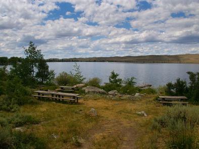
Sandy Beach Picnic Area is located on the southeast shores of pristine Fremont Lake at an elevation of 7,400 feet, just 3 miles northeast of Pinedale, Wyoming. Water sports and fishing are popular activities.

Recreation

The lake offers countless recreational activities. Anglers enjoy fishing for rainbow, brown and lake trout, as well as kokanee salmon.

Visitors also enjoy boating, sailing, canoeing, kayaking and swimming.

Facilities

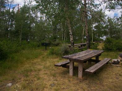
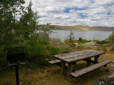
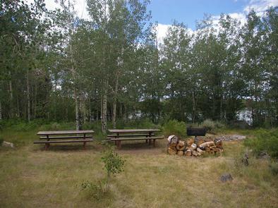
This day-use area contains one group site that can accommodate up to 75 guests. Picnic tables, grills and a fire ring with benches are provided, as are vault toilets.

A private, sandy swimming beach is on-site. A boat ramp and dock are available just outside the site. Roads and parking spurs are dirt.

Natural Features

Fremont Lake sits at the foot of the rugged Wind River Range, known for its craggy granite peaks and sparkling glacial lakes. Sandy Beach offers sweeping views of Fremont Lake, Wyoming’s second largest natural lake. Thin stands of aspens line the site, providing limited shade.

Nearby Attractions

The Museum of the Mountain Man in Pinedale features a large collection of Rocky Mountain fur trade era artifacts. Exhibits include American Indian and Mountain Man displays, as well as the history of the settlement of Sublette County, Wyoming.

Reservation

More from CampingHiking.net:

COSSATOT REEFS, Arkansas Campground Images, Info & Reservations

Directions From De Queen, Arkansas, head north on US-59/US-71. Continue for nearly 10 miles and turn Right at Gillham EZ-Mart. Turn right on Tower Road; go 1.3 miles turn left onto Gillham Lake road; go 4.3 miles turn right and follow signs into the campground. Phone 870-386-7261 Activities BOATING, CAMPING,

JIM HOGG PARK, Texas Campground Images, Info & Reservations

Directions From I-35, take Farm to Market Road 2338 west for 6 miles to Jim Hogg Road. Turn south and continue 2 miles to the park entrance. Phone 512-930-5253 Activities BOATING, CAMPING, FISHING, HIKING, HUNTING, WILDLIFE VIEWING, PADDLING, MOUNTAIN BIKING, BIRDING Keywords JIMH,LAKE GEORGETOWN,GEORGETOWN LAKE,LAKE GEORGETOWN Related Link(s) Rec Area

FALLEN LEAF CAMPGROUND, California Campground Images, Info & Reservations

Directions From South Lake Tahoe, take Highway 89 North from the junction of State Highway 50 and 89. In 3 miles, turn left on Fallen Leaf Road. The campground is about half a mile on the right. Phone 530-544-0426 Activities BIKING, BOATING, HISTORIC & CULTURAL SITE, CAMPING, INTERPRETIVE PROGRAMS, FISHING,

MANITOU LAKE PAVILION, Colorado Campground Images, Info & Reservations

Directions From Colorado Springs, travel on US Highway 24 approximately 18 miles to Woodland Park. Take Highway 67 north about 7 miles. Manitou Lake is on the right (east) side of the highway 1 mile north of Colorado Campground. Phone 719-636-1602 (INFORMATION ONLY, NO RESERVATIONS TAKEN AT THIS NUMBER) Activities