


Directions
From the town of Prairie City, OR., turn South (right) onto South Main Street. Follow South Main Street to the junction with Bridge Street, turn left onto Bridge Street. Follow Bridge Street past the local cemetery, the road then changes to County Road 62. Continue on County Road 62 approximately 7 miles to the junction with Forest Road 13. Turn left and follow Forest Road 13 East approximately 16.5 miles, the guard station will be on the right at the junction of Forest Road 13 and Forest Road 16.
Phone
541-820-3800
Activities
CAMPING, FISHING, HIKING, HORSEBACK RIDING, HUNTING, WILDLIFE VIEWING, MOUNTAIN BIKING, BIRDING, SNOWMOBILING
Keywords
None
Related Link(s)
Overview
Short Creek Guard Station is a great place to stay to enjoy the nearby Monument Rock and Strawberry Mountain wilderness areas, as well as the North Fork of the Malheur Scenic River. The cabin offers access to a variety of recreational activities, including hiking, hunting, fishing and viewing wildlife.
The cabin provides all the comforts of a home, including drinking water during the summer months. Guests are responsible for their own travel arrangements and safety, and must bring several of their own amenities.
Recreation
In the warmer months, popular activities include hiking, horseback riding, mountain biking, fishing and wildlife viewing around the cabin and in the nearby wilderness areas and the North Fork of the Malheur Scenic River.
There are moderate hiking trails near the cabin, and rugged hiking trails in the wilderness. The wilderness provides over a hundred miles of trails. The riparian habitat of the river lends itself to picnicking, fishing and observing all kinds of wildlife. The wilderness has many wildlife viewing opportunities as well.
Facilities
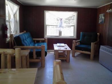
The kitchen is equipped with a propane cook stove, sink, propane refrigerator, propane lights and a propane heater that heats the entire facility. The small indoor bathroom provides a flush toilet and a shower during summer months only. Additionally, the building is equipped with a propane hot water heater, which provides hot water to the shower and sinks during the summer months only.
A picnic table, two BBQ grills and a fire pit are located next to the building, under the shade of nearby trees.
Guests will need to bring their own bedding (blankets, linens, pillows and/or sleeping bags), as well as flashlights or a lantern for emergencies, a first aid kit, towels, garbage bags and dish soap, among other necessities. The cabin will need to be cleaned and all garbage carried out prior to leaving.
Natural Features
The cabin is situated in a corner of a small meadow surrounded by tall ponderosa pines, at an elevation of about 5,000 feet. It is about 38 miles from the town of John Day, in eastern Oregon.
A babbling creek runs alongside the cabin and a variety of wildlife make its home in the area, including elk, deer, antelope, black bears, bighorn sheep, grouse, as well as many species of birds. Nearby, the Monument Rock and Strawberry Mountain wilderness areas, as well as the North Fork of the Malheur Scenic River, offer vast opportunities for exploration.
The Strawberry Mountain Wilderness has an extremely diverse ecological makeup, with five of the seven major life zones in North America and around 378 kinds of animals and approximately 22 fish species.