LAKESIDE DAY USE, TX Campground Reservation, Info, Images, Map, Directions

LAKESIDE DAY USE, Texas Campground Images, Info & Reservations

Directions

From Jefferson, Texas, travel 3.8 miles northwest on Highway 49. Turn left onto FM 729 and continue for 3.5 miles, then turn left again onto FM 726. Travel 3.5 miles the park entrance will be on the right.

Phone

903-665-2336

Activities

BOATING, FISHING, PICNICKING, WATER SPORTS, WILDLIFE VIEWING, DAY USE AREA, SWIMMING SITE

Keywords

Sandy Beach

Related Link(s)

Rec Area Info & Images

Texas State Tourism

Texas State Road Conditions

Overview

Lakeside Day Use Area is situated along the banks of the Lake O’ the Pines in the Ark-La-Tex portion of the Pineywoods of east Texas near the states of Arkansas, Oklahoma, and Louisiana.

Recreation

Boating, fishing, water sports, and wildlife viewing are all popular pastimes at the campground. Hunting opportunities for white-tailed deer, waterfowl, and small game are available on nearby public lands. Lake O’ the Pines fishing includes largemouth, spotted, and white bass along with crappie, catfish, and sunfish. In addition to boat fishing there are areas for bank fishing along the shore and below the dam along Big Cypress Bayou. Birdwatchers are also encouraged to bring their binoculars as numerous resident and migratory bird species inhabit the area. Bald eagle sightings are a common occurrence in fall and winter and they are occasionally sighted in spring and summer.

Facilities

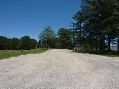
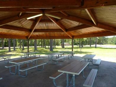
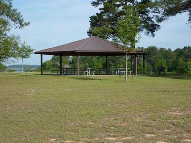
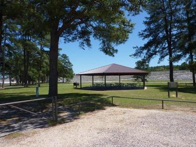
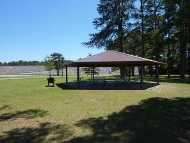
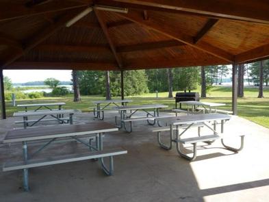
Lakeside Park offers one large group picnic shelter, complete with electric hookups, that can accommodate up to 100 guests. A boat ramp, dock and swimming beaches, and a volleyball court are also provided, making the area perfect for large parties or family functions.

Natural Features

Lakeside Day use is located near the Ferrell’s Bridge Dam. Lake O’ the Pines includes about 18,700 acres of water and 9,000 acres of land.

The lake was created by the construction of the Ferrell’s Bridge Dam on the Big Cypress Bayou. The reservoir was originally created as part of the overall plan for flood control in the Red River Basin below Denison Dam in Oklahoma, and has now become a recreational oasis for outdoor enthusiasts.

Nearby Attractions

Other historic and tourist attractions are nearby in the towns of Jefferson and Marshall, and Texas Wildflower Trail routes are located along the roads surrounding the lake.

Reservation

More from CampingHiking.net:

HENDERSON PARK, Arkansas Campground Images, Info & Reservations

Directions From Mountain Home, Arkansas, travel east on US Highway 62/412 10 miles to the town of Henderson. Look for park signs for the park entrance on the left. Phone 870-425-2700 Activities BOATING, CAMPING, FISHING, HUNTING, WATER SPORTS, DAY USE AREA, HOTEL/LODGE/RESORT PRIVATELY OWNED Keywords Related Link(s) Rec Area Info

OLD FEDERAL, Georgia Campground Images, Info & Reservations

Directions Take I-85 north to I-985, take Exit 8, turn left on Hwy 347/Friendship Rd., turn right on McEver Rd., turn left on Jim Crow Rd. and follow signs to the campground. Phone 770-967-6757 Activities BIKING, BOATING, CAMPING, FISHING, PICNICKING, SWIMMING SITE, SWIMMING, WATER ACTIVITIES, WATER ACCESS Keywords OLDF,LAKE LANIER,LAKE

UPPER ARCADIA, Arizona Campground Images, Info & Reservations

Directions From Safford, Arizona: Take State Route 191 south for 6 miles. Turn right onto State Route 366/Swift Trail and travel 11.5 miles to the Arcadia Campground entrance (MM 125.5), taking the next right turn to access Upper Arcadia.  From Tucson, Arizona: Take I-10 East for 90 miles. Take exit

D.H. Day Campground, Michigan Campground Images, Info & Reservations

Directions From Empire, MI: Drive north on M-22 for 2 miles to the intersection of M-109, turn left onto M-109, continue for another 5.3 miles (past the Scenic Drive, Dune Climb & entrance to the D.H. Day Group Campground), the entrance to the campground will be on your left.From Glen

LYNX CAMPGROUND, Arizona Campground Images, Info & Reservations

Directions From Phoenix, Arizona: Traveling Northbound on I-17 take Exit 262 onto Hwy 69 North to Prescott and cointnue on Hwy 69 for 30 miles to S Walker Rd. Turn left and proceed South on S. Walker Rd. (by Costco, Petsmart, and AM/PM gas station). Drive about 3 miles and

Rohrbach Group Campground, Maryland Campground Images, Info & Reservations

Directions The visitor center is located at 5831 Dunker Church Rd. off of MD Rt 65, ten miles south of I-70 and one mile north of historic Sharpsburg, Maryland. The campground is located at 18316 Burnside Bridge Road, Sharpsburg, MD 21782. Phone (301) 432-5124 Activities BIKING, HISTORIC & CULTURAL SITE,