MCGREGOR LAKE CAMPGROUND, MT Campground Reservation, Info, Images, Map, Directions

MCGREGOR LAKE CAMPGROUND, Montana Campground Images, Info & Reservations

Directions

From Libby, MT, take US Route 2 east 53 miles to campground sign. Turn right at sign and go 0.2 miles to campground.

An alternate route is to take US Route 2 west from Kalispell, MT, for 32 miles to campground entrance.

Phone

406-293-7773

Activities

BOATING, CAMPING, FISHING, HIKING, WILDLIFE VIEWING, MOTEL

Keywords

None

Related Link(s)

Rec Area Info & Images

Montana State Road Conditions

Montana State Tourism

Overview

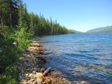
McGregor Lake Campground is located approximately 53 miles southeast of Libby, Montana, on Highway 2 at the west end of McGregor Lake in the Kootenai National Forest. This area is about halfway between Libby and Kalispell in the heart of the Thompson Chain of Lakes, a premier fishing and hunting area.

Recreation

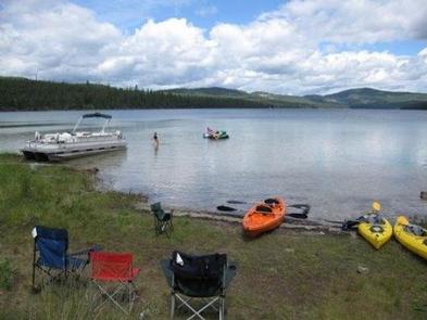
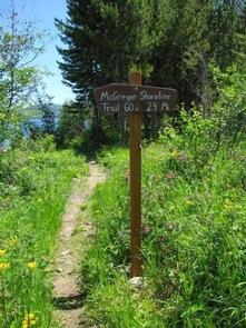
McGregor Lake is host to a prime mackinaw trout population and offers excellent opportunities for a trophy-size catch. There is a boat ramp on-site for access to the lake. Swimming and water skiing are also popular activities. Hikers can walk the 2.9-mile McGregor Lake Shoreline Trail.

Facilities

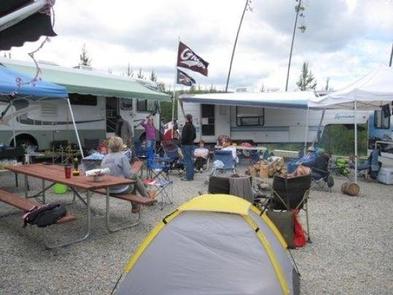
The campground has 27 sites, including one host site, all with tables and fire rings. Most sites offer an average length of 32 feet. Vault toilets, garbage service and drinking water are available during the peak season. The campground campsites are not currently on the reservation system. The reservable group site is available for large groups, this site is a 120′ x 140′ gravel parking area. Tables and fire ring are located within the site. Reservations can be made at Recreation.gov Day use picnic sites with tables and fire rings are located near the beach.

Natural Features

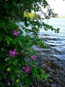
At an elevation of 3,900 feet, the campground is nestled among young pines at the west end of McGregor Lake in the Fisher River Area. The lake spans 1,240 acres, making it the largest lake in the Kootenai National Forest. The Fisher River Area is the watershed formed by the four forks (West, East, Silver Butte, Pleasant Valley) of the Fisher River and Wolf Creek. Within it is the Thompson Chain of Lakes, which consists of more than 20 lakes.

Reservation

More from CampingHiking.net:

PRINTER BOY, Colorado Campground Images, Info & Reservations

Directions From Leadville, Colorado, drive west on County Road 4 and follow signs to the Turquoise Lake Recreation Area. Phone 719-486-0749 (FOR INFORMATION ONLY. NO RESERVATIONS.) Activities BOATING, CAMPING, FISHING, HIKING Keywords PRIN,PIKE AND SAN ISABEL NF- FS Related Link(s) Rec Area Info & Images Forest Service Concessionaire Colorado State

RAINBOW (OR), Oregon Campground Images, Info & Reservations

Directions From Estacada, travel east on Highway 224/Road 46 for 26 miles to the campground. Phone 503-630-5721 Activities CAMPING, FISHING, HIKING, WATER SPORTS, WILDLIFE VIEWING Keywords RAIB,MT. HOOD NF – FS Related Link(s) Rec Area Info & Images Oregon State Road Conditions Oregon State Tourism Forest Service Concessionaire Overview Rainbow

PORUM LANDING, Oklahoma Campground Images, Info & Reservations

Directions From Porum, Oklahoma, take Texanna Road west for 7 miles, then follow signs to the campground. Phone 918-799-5843 Activities BOATING, CAMPING, FISHING, HIKING, SWIMMING SITE Keywords PORU,EUFAULA LAKE,EUFAULA LAKE Related Link(s) Rec Area Info & Images Oklahoma State Road Conditions Oklahoma State Tourism Overview Porum Landing Campground sits along

PIONEER POINT, California Campground Images, Info & Reservations

Directions From Bakersfield, California, take Highway 178 east to the town of Lake Isabella. From Lake Isabella take 155 north about 1.5 miles to Pioneer Point Campground. Phone 760-376-1815 Activities BOATING, CAMPING, FISHING Keywords PIOP,LAKE ISABELLA,KERN VALLEY,SEQUOIA NF – FS Related Link(s) Rec Area Info & Images California State Road

THIRD FORK CABIN, Idaho Campground Images, Info & Reservations

Directions From Boise, Idaho, take Highway 55 north to Horseshoe Bend. Turn left on Highway 52 and drive west 9 miles to the junction at Sweet/Ola Highway (no road number), then take a slight right. Take this road north 17 miles to Ola. Make a slight left and continue north