

Directions
From Naches, Washington, follow Highway 12 west for approximately 34 miles to County Road 1200/Tieton Reservoir Road at the west end of Rimrock Lake. Turn south/left on County Road 1200 and follow for about .3 miles to Road 740. Continue for a half-mile, and the reservation site is the second campsite on the left along the North Fork Tieton River. From Packwood follow Highway 12 east approximately 27 miles to County Road 1200/Tieton Reservoir Road. Turn south/right on County Road 1200 and follow for about .3 miles to Road 740. Continue for a half-mile, and the reservation site is the second campsite on the left along the North Fork Tieton River.
Phone
(509) 653-1401
Activities
FISHING, WILDLIFE VIEWING, SWIMMING, BIRDING
Keywords
CLGS,Clear Lake North,Grade Forest Camp,OKANOGAN – WENATCHEE NF -FS
Related Link(s)
Washington State Road Conditions
Overview
Clear Lake Group Campground is along the North Fork of the Tieton River in the Okanogan-Wenatchee National Forest.
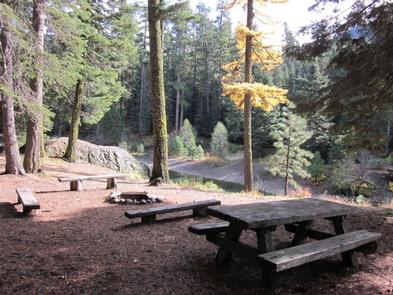
The campground sits between popular Rimrock Lake and the quieter Clear Lake beneath a canopy of towering pine and fir trees. Perched on a rocky bluff overlooking the area, this secluded spot offers access to a variety of recreational opportunities.
It is an ideal setting for large family and group gatherings.
Recreation
Clear Lake Group Campground offers outdoor enthusiasts the opportunity to hike, fish, ski, raft and enjoy a multitude of outdoor recreational activities throughout the year. Visitors enjoy the nearby Rimrock Lake for its myriad of water activities, including fishing for kokanee salmon or trout and kayaking along the shore. River enthusiasts may enjoy a whitewater rafting trip on one of the many scenic rivers in the area. The Tieton River is especially exciting in September, when the Bureau of Reclamation floods the Tieton Valley. The river is perfect for river enthusiasts seeking the thrill of whitewater.
Facilities
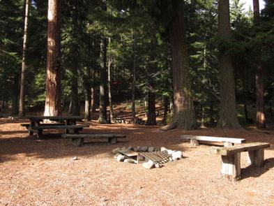
Clear Lake Group Campground is a single group site that can accommodate 40 guests. The parking area can hold about ten cars or five RVs and provides walk-in access to a large tent camping area. The site is equipped with picnic tables, accessible vault toilets and a group campfire ring.
Natural Features
Okanogan-Wenatchee National Forest offers stunning scenic views, with high, glaciated alpine peaks, valleys of old growth forest and rugged shrub-steppe country making up the diverse landscape. Elevations range from below 1,000 feet to more than 9,000 feet. Precipitation varies greatly throughout the area, ranging from approximately 140 inches along the Cascade Crest to only 10 inches along the eastern edge. Visitors can expect many days of warm, sunny weather in the summer, and winters with clear skies and plenty of snow. The Tieton River, adjacent to Clear Lake Group Campground, is a tributary of the Naches River. Its headwaters originate in Goat Rocks Wilderness, collecting water from snow melt and glaciers in high rugged peaks. These peaks are remnants of an extinct volcano, taking the name “Goat Rocks,” in honor of the mountain goats traversing this isolated region.
Nearby Attractions
Visitors enjoy Mt. Rainer National Park, where interpretive programs and exhibits offer education about the diverse landscape and history of the area. The spectacular Pacific Crest Trail (PCT), one of the world’s premier National Scenic Trails, showcases some of North America’s most fantastic scenery, winding its way its way from Mexico to Canada through California, Oregon and Washington, and is accessible near the campground. A boat ramp is available within 10 miles of the campground.