MCNAIR GROUP AREA, IL Campground Reservation, Info, Images, Map, Directions

MCNAIR GROUP AREA, Illinois Campground Images, Info & Reservations

Directions

From I-57, take Old U.S. Highway 50 west for 22 miles to the Dam East Entrance road. Turn north and continue through the four-way intersection to the McNair Group Area.

Phone

618-594-5253

Activities

BIKING, BOATING, CAMPING, FISHING, HIKING, WATER SPORTS, WILDLIFE VIEWING, SWIMMING SITE

Keywords

MCGR,DAM EAST REC AREA,SOUTH SHORE,CARLYLE LAKE

Related Link(s)

Rec Area Info & Images

Illinois State Road Conditions

Illinois State Tourism

Overview

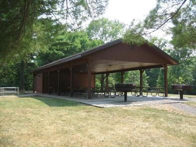
McNair Group Area has a reservable group shelter on the southern shore of Carlyle Lake, a prime getaway for city-dwellers and families. Located 50 miles east of St. Louis, the area offers the peaceful retreat of a small town combined with the grandeur of Illinois’ largest man-made lake.

Recreation

The area provides fun both on the water and on shore. Boat ramps and courtesy docks are provided, and the vast lake allows for plenty of water sports.

Fishing is a popular pastime, and white bass, bluegill, crappie, channel catfish, largemouth bass, freshwater drum, carp, flathead catfish and walleye can be found in abundance.

There is an on-site playground and plenty of open space for children to play in, as well as an amphitheater for educational programs.

Facilities

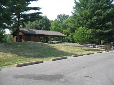
McNair Group Area has one reservable group picnic shelter that accommodate up to 80 people, as well as 32 first-come, first-served individual campsites. The facility also provides a swimming beach, bathhouses and laundry facilities. McNair has a nature trail and a multi-use trail, and is connected to the Dam East facilities.

Natural Features

Created in 1967, the 26,000-acre lake is recognized as one of the nation’s top ten inland sailing lakes and hosts several annual races and regattas.

Carlyle Lake is home to an array of wildlife that can be seen throughout the year. Its waters and shores are a resting spot for migratory waterfowl and other birds. There are six established Watchable Wildlife Sites with viewing towers open to the public around the lake.

Nearby Attractions

Carlyle Lake Visitor Center, located in the Dam West Recreation Area, has information, a gift shop and nature exhibits, including a 215-gallon aquarium with native fish and a display featuring a live massasauga rattlesnake.

Reservation

More from CampingHiking.net:

THUNDER RIDGE, Colorado Campground Images, Info & Reservations

Directions From the I-25 and Hwy 24 intersection in Colorado Springs, Colorado, travel west on Highway 24 for 17.4 miles to Baldwin St. in Woodland Park. Turn right (north) on Baldwin (which turns into Rampart Range Road). Travel approximately 3 miles to Loy Creek Road, turn right at the Y,

BLACK MOUNTAIN LOOKOUT, California Campground Images, Info & Reservations

Directions Access to the lookout is by a dirt road; high clearance vehicles are recommended. Visitors should be aware that access is subject to inclement weather during the early and late season. Black Mountain Lookout is located on the eastern edge of the Beckwourth Ranger District, 10 miles from Highway

STOCKDALE, Kansas Campground Images, Info & Reservations

Directions From the intersection of US-24 and K-13 at the west end of the dam, travel west on US-24.Tuttle Creek Blvd for 5 miles. Turn right on Riley County Road 895 and continue for 2 miles. Turn right again on Riley County Road 396/Stockdale Park Road and continue 2.5 miles

LAKE ALVA CAMPGROUND, Montana Campground Images, Info & Reservations

Directions From the junction of Montana Highways 200 and 83 (locally referred to as Clearwater Junction), travel north on Highway 83 for approximately 15 miles to the town of Seeley Lake. Continue north on Highway 83 for about 11 miles. The campground entrance is located on the west side of

VICTORIA CAMPGROUND, Georgia Campground Images, Info & Reservations

Directions From I-575, take exit 11 and turn west onto Sixes Road. After 2.5 miles turn left on Bells Ferry Road and follow the signs to the campground. Physical address: 937 Victoria Landing Drive Woodstock, GA 30189 Phone 678-721-6700 Activities CAMPING, FISHING, SWIMMING SITE Keywords VICT,ALLATOONA LAKE,ALLATOONA LAKE Related Link(s)

BRUSHY CREEK DAY USE, Texas Campground Images, Info & Reservations

Directions From Jefferson, Texas, travel 3.8 miles northwest on Highway 49. Turn left onto FM 729 and continue for 3.5 miles, then turn left again onto FM 726. Travel 5.0 miles turn right at the stop sign and follow signs to the park entrance. Phone 903-777-3383 Activities BOATING, FISHING, WILDLIFE