CANAL CREEK, OR Campground Reservation, Info, Images, Map, Directions

CANAL CREEK, Oregon Campground Images, Info & Reservations

Directions

From Waldport, Oregon, take State Route 34 east 7 miles to the campground sign at Canal Creek Rd../Forest Service Rd. 3462. Turn right onto Canal Creek Rd./FSR 3462 and go 4 miles to another campground sign and turn left into the campground.

Phone

541-528-7725

Activities

FISHING, HIKING, BERRY PICKING, CRAWFISHING

Keywords

CANC,CANAL,SIUSLAW NF – FS

Related Link(s)

Rec Area Info & Images

Forest Service Concessionaire

Oregon State Tourism

Oregon State Road Conditions

Overview

Canal Creek is a group campground where campers can truly get away from the hustle and bustle of the city and immerse themselves in nature. The facility is comprised of two group campsites, each providing a tranquil, scenic setting.

Recreation

Site 001 has a large open space that provides room for sports like soccer, Frisbee and football. Campers are urged to bring sports equipment, as none is provided.

Other activities include fishing and crawfishing, hiking, tubing and swimming. Cutthroat trout inhabit Canal Creek.

Facilities

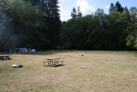
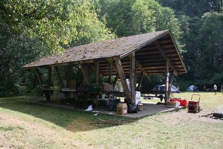
Site 001 is accessed by fording the gentle creek. It has a large open field with a picnic shelter, tables and a campfire circle. The site accommodates up to 100 people and 20 vehicles. RVs are not recommended.

Site 002 is bordered by the creek. It is made up of 10 separate campsites surrounding a central dining area with tables and a campfire circle. The site accommodates up to 50 people and 10 vehicles. RVs are welcome.

Vault toilets are provided, but no drinking water or electric hookups are available at either site.

Natural Features

Canal Creek flows through the campground, dividing the two sites, which are shaded by Douglas fir and spruce trees. Huckleberry bushes dot the forest floor. Roosevelt elk and bald eagles make their homes in the surrounding area.

The campground is part of Siuslaw National Forest, which extends across the lush forests of the coastal mountains to the Oregon Dunes and beaches of the Pacific Ocean.

Nearby Attractions

Sandy beaches stretch north and south of Waldport, about 20 minutes from the campground. Beautiful Cape Perpetua Scenic Area is another 15 minutes south of Waldport. Mary’s Peak is the highest point in Oregon’s Coast Range and has been designated a Scenic Botanical Area because of its rich, unique scenery and plants.

Reservation

More from CampingHiking.net:

FORKS OF HUNTINGTON, Utah Campground Images, Info & Reservations

Directions The campground is 16 miles west of Huntington, Utah, along Highway 31. Phone (435)384-2372 Activities BIKING, CLIMBING, CAMPING, FISHING, HIKING, WILDLIFE VIEWING Keywords FORH,MANTI-LASAL NF -FS Related Link(s) Rec Area Info & Images Utah State Tourism Utah State Road Conditions Overview Forks of Huntington Campground is located in beautiful

LITTLE MILL, Utah Campground Images, Info & Reservations

Directions From Salt Lake City or Provo, take I-15 to the Alpine-Highland exit 284. Travel 8 miles east on Utah Highway 92 to the mouth of American Fork Canyon. Stay on 92 for 4 miles to the campground. Phone PLEASANT GROVE RANGER DISTRICT 801-785-3563 OR UTAH RECREATION COMPANY 385-273-1100 Activities

GREEK CREEK CAMPGROUND, Montana Campground Images, Info & Reservations

Directions From Bozeman, travel south on Highway 191 for 30 miles, to the campground. From West Yellowstone, travel north on Highway 191 for about 59 miles. Phone (406)646-1012 Activities CAMPING, FISHING, WILDLIFE VIEWING, PHOTOGRAPHY, KAYAKING, STAR GAZING, BIRDING, WATER ACCESS, RAFTING Keywords GREK,GALLATIN NF – FS Related Link(s) Rec Area

ROCKY POINT (FT GIBSON), Oklahoma Campground Images, Info & Reservations

Directions From Wagoner, Oklahoma: travel 4.5 miles north on Highway 69. Turn right at stoplight on East 690 Road. Travel 3 miles east. Turn left on South 320 Road and travel north for 3/4 mile to park entrance. Phone 918-462-2042 OR 918-682-4314 Activities BOATING, CAMPING, FISHING, HUNTING, SWIMMING SITE Keywords

PINE ISLAND GROUP AREA, Wyoming Campground Images, Info & Reservations

Directions Located 27 miles west of Dayton, Wyoming, on U.S. Highway 14. Phone 406-587-9054 Activities BIKING, BOATING, CAMPING, FISHING, HIKING, WILDLIFE VIEWING Keywords PIIS,PINE ISLAND,BIGHORN NF – FS Related Link(s) Rec Area Info & Images Overview Pine Island Group Area is located along the Bighorn Scenic Byway (U.S. Highway 14)

SOLDIER CREEK, Utah Campground Images, Info & Reservations

Directions From Heber City, Utah, take Highway 40 east for 32 miles to Soldier Creek Junction. Turn right and follow south for 2 miles to the campground. Phone HEBER RANGER DISTRICT 435-654-0470 OR UTAH RECREATION COMPANY 385-273-1100 Activities BOATING, CAMPING, FISHING, HIKING, MOUNTAIN BIKING, WATER ACTIVITIES Keywords SOLD,UINTA NF –