
Directions
From Douglas (37 miles)
From I25 Exit 140, turn right onto S Riverbend Dr. Turn right onto WY-94 (Esterbrook Road) and right on WY-91 (Cold Springs Road). In 3 miles, turn left on WY-91 (Cold Springs Road). Continue on CR 24 (Cold Springs Road) for 33.8 miles.
From I25 Exit 146, East on WY-96. In 3.1 miles, turn right on WY-91 (Cold Springs Road). Continue on CR 24 (Cold Springs Road) for 33.8 miles.
From Laramie (105 miles)
Follow HWY 30 (N) from Laramie to Medicine Bow. Take HWY 487 North and turn right on CR 62 (32 Mile RD/Little Medicine Road) for 29.8 miles and continue on CR 24 (Cold Springs Road) for 4.4 miles.
Phone
307-358-4690
Activities
BIKING, CAMPING, FISHING, HIKING, HORSEBACK RIDING, HUNTING, WILDLIFE VIEWING
Keywords
LAPR,La Prele Guard Station,La Prele Cabin,Cold Springs Cabin,La Prele Ranger Station,La Prele Work Center,MEDICINE BOW-ROUTT NF-FS
Related Link(s)
Overview
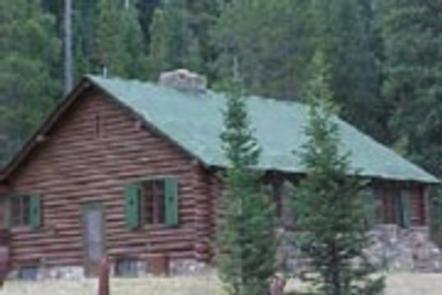
La Prele Guard Station is located south of Douglas, Wyoming in Medicine Bow-Routt National Forest. It was originally built as a remote ranger station in 1936 by the Civilian Conservation Corps and was converted into a work center when the La Prele Ranger District was discontinued in 1956.
The site was listed on the National Register of Historic Places in 1994. Today, it provides a unique lodging experience and delightful spot for guests seeking recreation and relaxation in south central Wyoming.
The guard station is open from late May through early October each year and is accessible by car. Weather and road closures may impact opening and closure dates. Many modern conveniences are provided, but guests will need to bring a few of their own supplies to make their stay comfortable. There is no electricity, the Forest Service provides battery operated lanterns for use. Please note that candles or other flame producing items are not permitted in the cabin.
Recreation
Hiking, fishing, rock climbing, mountain biking, horseback riding and hunting can be found within the vicinity. Off-road vehicle riders can access trails in the area as well.
The trailhead for the Twin Peaks trail is three miles north of La Prele Guard Station and provides great access for elk and deer hunters. The trail meanders through both private and public land to the base of Twin Peaks. From the top of the peaks, views of the Laramie Mountains dominate the landscape.
Anglers will enjoy fly fishing for a variety of trout at La Prele Creek within walking distance from the cabin.
Facilities
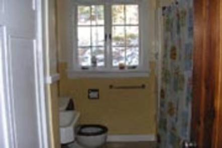
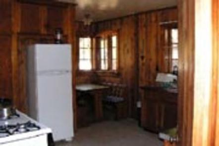
The log structure has two bedrooms equipped with beds and mattresses that can accommodate up to ten people. The kitchen offers a refrigerator, stove, table with chairs, basic cooking and eating utensils, and cookware. The cabin has indoor plumbing, giving guests access to running water, a shower and a flush toilet; however, it is recommended that you bring drinking water. A propane water heater provides hot water.
The cabin does not have electricity. The fireplace upstairs is usually adequate for heating the guard station during the summer. No flame producing sources are allowed in the cabin, including candles. A campfire ring is just outside.
Guests need to provide their own food, sleeping bags, pillows, towels, dish soap, matches, first aid kit, toilet paper and garbage bags. An emergency light source is recommended. There is no trash collection; all trash, food, and personal items must be taken with you at check out.
Campbell Creek Campground, about 1/2 mile east of the La Prele Guard Station, has six campsites that can accommodate tents, campers and trailers up to 22 feet. Campsite #1 can accommodate a longer trailer of 30 feet.
No Vehicle or ORV driving is allowed off the gravel parking area. Unloading/loading and driving from the parking area to Cold Springs Road is the only driving allowed in the compound.
No additional RV’s, campers or tents are allowed without prior approval from the Douglas Ranger District Recreational Specialist.
ORV reminder:
Forest Service Trails require Wyoming ORV sticker and ORV less that 50″ in width.
Forest Service Roads require either Wyoming ORV sticker or plated vehicle.
County & State Roads require plated vehicle – including ORV’s.
Natural Features
The guard station sits in a grassy clearing surrounded by a mixed conifer forest at an elevation of 7,800 feet. Mountains define the landscape and La Prele Creek flows nearby.
Wildlife viewing is abundant near the cabin, including elk and deer. Migratory birds, squirrels and an occasional black bear find habitat in the forest as well.