Directions
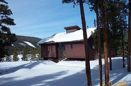
From Saratoga, Wyoming, travel south on Highway 130 for 8 miles to the junction of Highway 130 and Highway 230. Turn east on Highway 130 and travel for 12 miles to the Brush Creek Work Center. Turn into the work center and park at the bi-level house. The driveway is plowed to the Brush Creek Barracks.
Phone
307-326-5258
Activities
CAMPING, WINTER SPORTS, WILDLIFE VIEWING
Keywords
BCWB,Brush Creek Work Center,Brush Creek VIC barracks,Brush Creek Barracks,MEDICINE BOW-ROUTT NF-FS
Related Link(s)
Overview
The cabin offers an ideal winter playground, with a snowy landscape perfect for recreation. Snowmobiling, skiing and snowshoeing are popular activities. The Brush Creek Cross-Country Ski Trails are made up of loop trails winding through aspen, lodgepole pine stands and reclaimed clear-cuts. The frequency of trail grooming depends on weather conditions and equipment.
Recreation
After the Wyoming Highway Department closes their gate for the winter the highway becomes a popular snowmobile trail. The Wyoming State Trails map shows over 300 miles of groomed and ungroomed trail. A new map is created each year.
Other recreational opportunities in the area include cross country skiing on the trails behind the Barracks and sledding at the old Ryan Park Ski Area.
Facilities
This bi-level house can accommodate up to eight people comfortably in four bedrooms with a set of twin beds in each. The small living room has a TV, but reception is weak. The large kitchen and dining area is equipped with a refrigerator, stove, microwave, basic kitchen utensils and cooking supplies. Two bathrooms include showers and flush toilets. The house has electricity and heat.
Guests should bring a few of their own supplies, including food, sleeping bags, pillows, towels, dish soap, extra toilet paper and garbage bags. Additional light sources should be brought for emergencies. All trash and food should be packed out, and guests are expected to clean the cabin before leaving.
Natural Features
The Snowy Range is aptly named. The Barracks, at 8,100 feet, receives early autumn snow and by Halloween the snow is beginning to accumulate. Eight miles up from the Barracks is the Highway 130 winter closure gate.

