


Directions
Take exit 63 off I-15 just south of Pocatello. Follow the brown "Mink Creek Recreation Area" signs to Bannock Highway for 2 miles, then turn left up Mink Creek Canyon. Go 7 miles south on Bannock Highway, past Bannock Guard Station, to the campground.
Phone
208-236-7500
Activities
CAMPING, WILDLIFE VIEWING
Keywords
MCGC,Mink Creek,Mink Creek Group Site,Mink Creek Campground,CARIBOU-TARGHEE NF – FS
Related Link(s)
Overview
Mink Creek Group Site Campground is located just 12 miles south of Pocatello, Idaho, along the Bannock Highway. The Mink Creek area is a popular area for birding and wildlife viewing, with many miles of multi-use trails waiting to be explored.
Recreation
The West Fork Mink Creek Trail begins just outside the campground and is popular with hikers, mountain bikers and horseback riders. Additional trails including Corral Creek Trail and Valve House Trail are in the vicinity.
Facilities
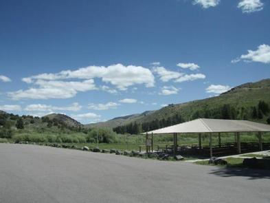
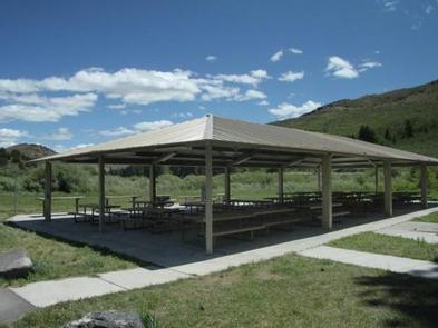
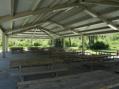
The campground offers one large accessible group site that can accommodate up to 200 people. The site contains a 40×80-foot picnic pavilion with concrete base, large paved parking area, 12 large picnic tables, two serving tables and a large fire ring, two accessible vault toilets and four potable water hydrants. The pavilion has two electrical outlets and night lighting.
The road to the campground is paved, allowing easy access for RVs and cars. Security is provided by a locked entrance gate, area campground hosts and periodic county sheriff patrols.
Mink Creek Group Area is popular for outdoor weddings; if you plan to move any site furniture please call the District Office for approval at (208) 236-7500. Remember that site check-in time is 2:00 pm on the day of your reservation and check-out time is noon of the following day. Firewood is not provided and is not available on site for gathering. Garbage service is not provided.
Natural Features
The campground is situated along Mink Creek in the scenic Bannock Mountain Range of southeastern Idaho. A grove of ponderosa pines borders one side of the site, offering partial shade. Aspens and pines dot the surrounding mountainsides.
A wide variety of birds can be found in the area, including the Western Scrub-Jay, Juniper Titmouse, Bushtit, Blue-gray Gnatcatcher, Mountain Bluebird and Green-tailed and Spotted Towhees and Calliope Hummingbirds.
Nearby Attractions
Cherry Springs Nature Area is nearby, with its pretty namesake spring, a stream for fishing, paved self-guided nature trails and picnic facilities. Mink Creek Nordic Center is also nearby, with hiking and horseback riding trails in summer months and groomed cross-country ski trails in the winter.