RIO GRANDE VILLAGE GROUP CAMPGROUND, TX Campground Reservation, Info, Images, Map, Directions

RIO GRANDE VILLAGE GROUP CAMPGROUND, Texas Campground Images, Info & Reservations

Directions

From Interstate 10, take State Highway 385 south to Fort Stockton and into Marathon. From Marathon, drive 40 miles south on State Highway 385 to the north entrance of Big Bend National Park. Drive straight for 26 miles to Park Headquarters at Panther Junction. Turn left and proceed for 20 miles to the Rio Grande Village area. At the stop sign, turn right, then veer right for the group campground.

Phone

432-477-1121

Activities

BOATING, HISTORIC & CULTURAL SITE, CAMPING, FISHING, HIKING, PICNICKING, WILDLIFE VIEWING, BIRDING

Keywords

RGGR,RGV GROUP,VILLAGE GROUP,BIG BEND NATIONAL PARK,BIG BEND

Related Link(s)

Rec Area Info & Images

Texas State Road Conditions

Texas State Tourism

Overview

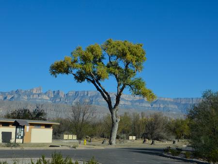
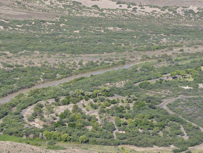
The Rio Grande Village Group Campground sits on the banks of the Rio Grande, the International Boundary between the United States and Mexico. The four group campsites are great options for groups of nine people or more and is one of the most popular campgrounds in Big Bend National Park. It is located close to Boquillas Canyon and Hot Springs, and acts as a launch point for visitors accessing the river or the endless miles of backcountry roads. Rio Grande Village has an outstanding view of the Sierra del Carmen Mountains, located in Mexico to the east, which light up with hues of red and orange during sunset.

Recreation

The river offers ample opportunities to explore its shores and water. The river put-in allows easy access to canoeing and kayaking on the river. Birders flock to the river banks to spot such rare and unique species often found only in Big Bend.

Hiking trails are also found nearby the campground and many backcountry roads are located near the campground.

Facilities

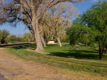
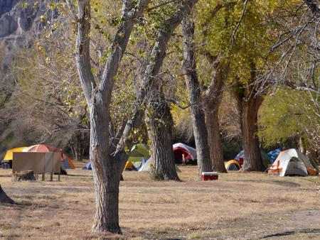
The group campsites are tent-only; RVs and trailers are not allowed. There are no hook-ups available in the group sites and generators are prohibited. Each site is provided with a picnic table, charcoal grill and bear-proof food storage locker. All four group sites are within easy walking distance to water spigots and restrooms. Showers and laundry facilities can also be found close by at the Rio Grande Village Store.

Natural Features

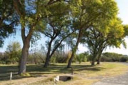
The mountain views, proximity to the river and shade from the surrounding cottonwood trees make Rio Grande Village Campground irresistible to visitors. This facility is at an elevation of 1,850 ft. Because cold air tends to sink into lower valleys during the peak seasons of fall and winter, temperatures are cooler here than in other parts of the park during these times. However, temperatures from March to September can easily exceed 100 degrees Fahrenheit.

Reservation

More from CampingHiking.net:

MCKINNEY CAMPGROUND, Georgia Campground Images, Info & Reservations

Directions Physical address: 6659 McKinney Campground Road, Acworth, GA 30102 From I-75 take exit 278 and turn north onto Glade Road. Continue for approximately 3 miles, then turn left onto King’s Camp Road. After about a mile continue left at the fork and follow signs to the campground. Phone 678-721-6700

RIVER EDGE, Oregon Campground Images, Info & Reservations

Directions From Waldport, head east on Highway 34 for about 26 miles and look for campground signs on the right. Phone 541-528-7725 Activities BIKING, BOATING, CAMPING, FISHING, HIKING, HUNTING, WILDLIFE VIEWING, SWIMMING, MOUNTAIN BIKING, CANOEING, BERRY PICKING Keywords REDG,RIVERS EDGE,RIVEREDGE,RIVERSEDGE,RIVER SIDE,SIUSLAW NF – FS Related Link(s) Rec Area Info &

Monument Lake Campground, Florida Campground Images, Info & Reservations

Directions From Naples: Follow US HWY 41 east until you see the sign for campground (approximately mile marker 59). From Miami: Follow US HIWY 41 west until you see the sign for campground (approximately mile marker 59) Phone 1 (239) 695-1205 Activities CAMPING, FISHING, HUNTING, DAY USE AREA Keywords Big

ALUM CREEK BELOW DAM AREA, Ohio Campground Images, Info & Reservations

Directions From Columbus, Ohio, take I-71 north to exit 121 for Polaris. Turn right on Polaris Parkway, left on Worthington Road, left on Africa Road, then left on Lewis Center Road. Shelters are in the Below Dam Area. Phone 740-548-6151 Activities BIKING, BOATING, CAMPING, INTERPRETIVE PROGRAMS, FISHING, HIKING, HORSEBACK RIDING,

MENDENHALL CAMPGROUND, Alaska Campground Images, Info & Reservations

Directions This campsite is approximately 13 miles from downtown Juneau. Access is via the Alaska Marine Highway or via Alaska Airlines. By ferry: turn right out of the Ferry Terminal parking lot. Drive 1.7 miles to DeHart’s Store above Auke Bay marinas. Take a left turn onto Back Loop Road.

JOHNSON CREEK DAY USE, Texas Campground Images, Info & Reservations

Directions From Jefferson, Texas, travel 3.8 miles northwest on Highway 49. Turn left onto FM 729 and continue for just over 8.5 miles. Park entrance will be on the left. Phone 903-665-2336 Activities BOATING, FISHING, PICNICKING, WATER SPORTS, WILDLIFE VIEWING, DAY USE AREA, SWIMMING Keywords None Related Link(s) Rec Area