
Directions
From John Day, OR., travel south on Highway 395 approximately 17 miles to County Road 63 (Izee Highway). Turn right and take County Road 63 to the junction of Forest Service Road 24. Turn right and take Forest Road 24 approximately 10 miles. Turn left onto Forest Service Road 514. Travel about 1/4 mile staying to your right until you reach the locked gate that allows entry to the facility grounds.
Phone
541-820-3800
Activities
CAMPING, FISHING, HIKING, HORSEBACK RIDING, HUNTING, WILDLIFE VIEWING, BIRDING, WILD HORSE VIEWING
Keywords
DCGR,MALHEUR NF – FS
Related Link(s)
Overview
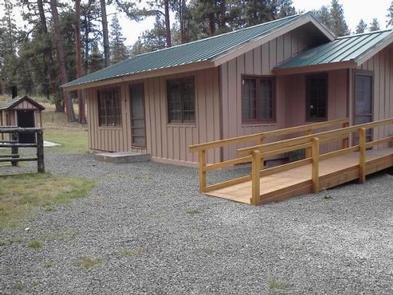
Deer Creek Guard Station is located approximately 31 miles from the town of John Day, in central Oregon. It is in a beautiful, quiet location, off the beaten path. From sunup to sundown, the cabin affords opportunities for adventure in exploring, viewing wildlife, or just relaxing and enjoying the wonders of nature all around. The cabin is larger than some, is furnished and offers many comforts. It can be accessed by vehicle. Guests are responsible for their own travel arrangements and safety, and must bring several of their own amenities.
Recreation
Big game hunting is popular in the area, as well as fishing on Deer Creek and South Fork John Day. Anglers might watch for coho, winter steelhead, spring chinook, fall chinook and cutthroat trout, among others in the area. Guests can also enjoy hiking and horseback riding on a variety of trails in the area.
Facilities
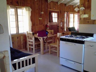
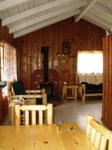
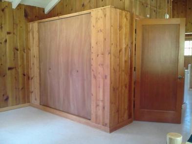
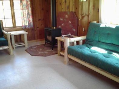
The rustic cabin has a living room/sleeping area, a small bedroom and a kitchen. The living/sleeping area is equipped with a propane fireplace for heat, a couch, chair and end tables. A Murphy bed is located in the living/sleeping area for additional sleeping space and can be put away during the day.
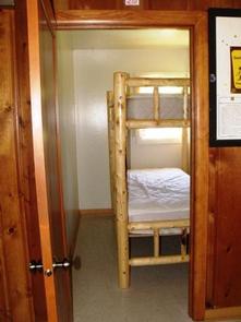
In the dining area is a full futon bed and table with four chairs. In a small room just off the dining area is a log bunk bed that can sleep two comfortably. The cabin can accommodate up to six people. The kitchen is equipped with a propane cook stove and propane refrigerator, ample counter space, pots, pans, plates, bowls, cups and flatware. The entire cabin is lit with propane lights.
An accessible vault toilet is located near the guard station. A picnic table and campfire ring are situated next to the perennial creek that runs through the facility grounds. Any water taken from an outdoor source should be boiled or treated prior to consumption. Stream water gets scarce during mid-August. Firewood can be collected from the surrounding area.
Guests should bring their own water for drinking, cooking and cleaning purposes, as well as bedding (linens, blankets, pillows and/or sleeping bags), flashlights or a lantern for emergencies, a first aid kit, towels, garbage bags and dish soap. Guests will need to clean the facility and carry out all trash prior to leaving.
Natural Features
The three-room cabin was built in 1956 and was originally used as a work station by fireguards. Before satellite surveillance systems, fireguards were the smoke chasers who rushed to sites of reported smoke and tried to extinguish the flames. Douglas fir and ponderosa pine trees dot the broad, flat expanse surrounding the cabin, which sits at an elevation of 5,100 feet. Deer Creek runs through the area nearby. In the spring and summer, guests enjoy abundant wildflowers and wildlife in the area, including wild horses, elk, black bears, deer and wild turkeys and other species of birds.