
Directions
From Buena Vista, Colorado, head north about 17 miles on Highway 24. Turn left on County Road 390 heading west. Drive about 9 miles and turn south on the cabin access drive which is gated; the cabins will be visible immediately on the right. There are 4 cabins; the rentable cabins are the first two and will be clearly marked with 1 and 2.
Phone
719-486-0749 (INFORMATION ONLY, NO RESERVATIONS)
Activities
HISTORIC & CULTURAL SITE, CAMPING, FISHING, HIKING
Keywords
CRMC,PIKE AND SAN ISABEL NF- FS
Related Link(s)
Colorado State Road Conditions
Overview
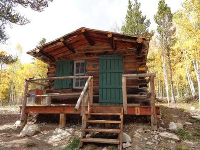
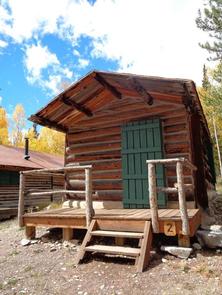
Cabin campers can escape the city – and escape modern day amenities – by staying at the fully rustic, historic Crescent Mining Camp cabins. The cabins offer a true old fashioned taste of life on the mine in the 19th century, with no electricity or running water. Visitors can focus on the sounds of nature and the incredible views of the Rocky Mountains from its creekside location. The mining camp was built in the 1890s during the boom of mining and milling in Clear Creek Canyon. Miners sought mostly gold and silver, and attracted about 50,000 residents in the valley that is now rather remote. The cabins are adjacent to a road heavily used by off-highway vehicles (OHV) but have a private drive with a locking gate. Crescent Mining camp is a good location for OHV enthusiasts, but not visitors seeking quiet and solitude
Recreation
Off-road vehicle trails begin near the site of the cabins and hiking trailheads are within several miles. The most popular trails lead into the Collegiate Peaks Wilderness, which boasts nine mountain peaks over 14,000 feet.
Facilities
There are four cabins at Crescent, but only cabins Numbered 1 and 2 (one and two) are available for reservations. The two cabins are rented together; one cabin sleeps two, the other sleeps four. Visitors must bring furniture such as cots, portable tables and chairs; in addition, tent and RV camping is permitted for those who rent the site. No water, heat, electricity, or trash service is provided. Guests should bring plenty of water. Creek water may be boiled and treated for consumption. Other items to pack include cook stove, bedding, food, lanterns, matches, cooking utensils, dish soap, bring firewood or an axe to collect (dead/down trees only), and a first aid kit.
Natural Features
Crescent Mining Camp is located within the Leadville Ranger District, which is home to the Sawatch Range, the highest mountain range in Colorado. These rugged, glaciated mountains form the crest of the Continental Divide. Mount Elbert, at 14,443 feet, is Colorado’s highest peak and 1 of 10 “fourteeners” located on the District.
At an elevation of approximately 10,000 feet, Crescent Mining Camp sits at the base of Ervin Peak in Clear Creek Canyon. It is on the outskirts of the Collegiate Peaks Wilderness in the Sawatch Range of the Rocky Mountains. Clear Creek passes near the cabins and the Clear Creek Reservoir and the Arkansas River Valley are 9 miles east.
Nearby Attractions
The nearest spot for pay phones and a grocery store is in Buena Vista, about an hour’s drive.
Visitors can head to Clear Creek Reservoir, about 9 miles east, for fishing and boating. Fish species include brook trout, brown trout and tiger muskie. A few miles further is the Arkansas River, in a section where whitewater rafting is popular.