


Directions
From Brookings and U.S. Highway 101, drive east on North Bank Chetco River Road (County Road 784). This becomes Forest Service Road 1376 in approximately 8 miles. Turn left after crossing the South Fork Bridge (16 miles from Brookings). Turn right on Forest Service Road 1917, approximately 1 mile after the bridge. Follow Quail Prairie signs staying on Forest Service Road 1917. The lookout is 3 miles beyond Packer’s Cabin. The total distance is 26 miles.
The roads are generally one-lane and gravel, with pullouts. Many people use these roads, including logging trucks, forestry workers, and recreational vehicles. Drive slowly, stay to the right side of the road at all times, and use pullouts.
Phone
541-412-6000
Activities
CAMPING, INTERPRETIVE PROGRAMS, FISHING, HIKING, WILDLIFE VIEWING
Keywords
QUAP,SISKIYOU,ROGUE RIVER,ROGUE RIVER NATIONAL FOREST,SISKIYOU NATIONAL FOREST,ROGUE RIVER-SISKIYOU NATIONAL,ROGUE RIVER SISKIYOU NATIONAL,ROGUE RIVER-SISKIYOU,ROGUE RIVER SISKIYOU,ROGUE RIVER – SISKIYOU NF – FS
Related Link(s)
Overview
THIS FACILITY IS CLOSED TO RESERVATIONS UNTIL FURTHER NOTICE
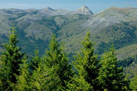
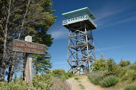
Quail Prairie Lookout offers guests a unique lodging experience in the Rogue-Siskiyou National Forest in western Oregon. On a clear day, visitors are treated to spectacular views of the Kalmiopsis Wilderness from the top of the 41-foot tower.
The tower was completed in 1963 and served as one of the last lookouts built by the southwestern Oregon Forest Service until the mid 1990’s, when it was converted for recreational purposes.
Today campers can enjoy a unique lodging experience in the historic structure, which offers basic amenities and spectacular views of the surrounding area. Although the facility provides basic amenities, guests must bring a few of their own supplies to ensure a safe and comfortable stay.
Recreation
The nearby Upper Chetco Trail is the main east/west route through the Kalmiopsis Wilderness. It offers access to the Chetco River and two main tributaries. Heavy vegetation provides shade but eliminates most views, and at least three significant long and steep sections provide a challenging backpacking experience.
Anglers will enjoy the remote location and scenic backdrop of the nearby Chetco River, providing angling opportunities for trout, steelhead, and salmon in season. The Chetco starts in steep, deeply dissected, sparsely vegetated, mountainous terrain within the Kalmiopsis Wilderness.
At night the lookout is an ideal setting for stargazing, as constellations and planets put on a dazzling display.
Facilities
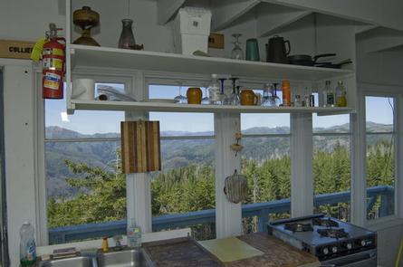
The one-room lookout rests on the top of a 41-foot timber tower, surrounded by a catwalk. It is furnished with a single bed, a table and two chairs, a stool, broom and fire extinguisher. It also features a wood stove, a propane stove for cooking and a propane refrigerator. A vault toilet is located near the tower.
There is no water or electricity available at the site. Guests must bring water for drinking, cooking and washing. In addition, visitors will need to supply a light source, sleeping bags, sleeping pads, cooking gear, towels, dish soap, matches, a first aid kit, toilet paper and garbage bags. Firewood is provided.
Natural Features
The lookout affords panoramic views of the Kalmiopsis Wilderness and the Chetco River drainage. The Kalmiopsis Wilderness is an area of great geological and botanical interest. Many of the rocks were formerly parts of the oceanic crust, while diverse plant life provides evidence of adaptation to the area’s harsh soils.
The Kalmiopsis leachian, a shrub discovered in the Gold Basin area in 1930, is a relic of the pre-ice age. The Kalmiopsis Wilderness is named after this unique endemic plant.
Diverse landscapes provide habitat for a wide-range of wildlife, from spotted owls and black-tail deer to salamanders and salmon. These species, along with many others, depend on surrounding undeveloped wilderness, undisturbed wetlands, clean streams, and diverse forests to live.