


Directions
From Blue River, OR, travel approximately 4 miles east on Highway 126 to Aufderheide Drive/Forest Service (FSR) 19. Turn right and proceed south for approximately 17 miles on Auderheide Drive past Cougar Reservoir to Box Canyon Guard Station. From I-5 in Eugene, OR, take exit 158 for Highway 58 toward Klamath Falls/Oakridge. Travel 31.4 miles on Highway 58, then turn left at the Westfir-Oakridge road. After 1/2 mile turn left on North Fork Road. Stay right to continue on Aufderheide Drive/FSR 19. Box Canyon Guard Station is approximately 32.5 miles from Highway 58.
Phone
541-822-3381
Activities
CAMPING, HIKING, HORSEBACK RIDING, WILDLIFE VIEWING, MOUNTAIN BIKING, BIRDING
Keywords
BOXC,WILLAMETTE NF -FS
Related Link(s)
Overview
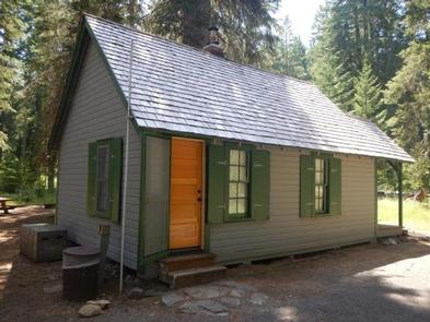
Box Canyon Guard Station sits beneath a canopy of Douglas fir at an altitude of 3,620 feet on the West Cascades National Scenic Byway. It is located approximately 75 miles southeast of Eugene, Oregon in the Willamette National Forest. The guard station was built by the Civilian Conservation Corps in 1933 and used as a dwelling for fire guards. They were the smoke chasers, often riding on horseback through the tall timbers to the location spotted by the lookout tower guards. The first on the scene, they often tried to put out any fires they may have found on their own, or reported back for additional help. The guard station is open from early May through the end of October and is easily accessible by car. Some creature comforts are provided, but guests should be prepared to pack in most of their own supplies and gear.
Recreation
Trailheads into the Three Sisters Wilderness and the Chucksney Mountain Roadless Area are adjacent to the Guard Station. The nearby Box Canyon Trail Area offers a variety of multi-use trails for mountain bikers, equestrians and hikers.
Facilities
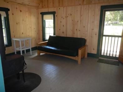
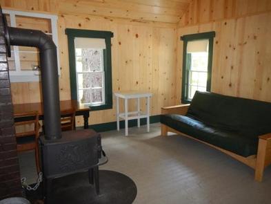
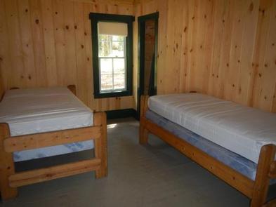
The 16×24-ft. cabin sleeps 4 and comes furnished with 2 twin beds with mattresses, a desk, a sofa bed, a table with chairs, wood stove and cleaning supplies. An outhouse, fire ring and picnic table are located nearby. A horse corral that measures approximately 45 feet in diameter is provided. Electricity, firewood and potable water are not provided. Guests must bring plenty of water for drinking, cooking and washing. Water is available from a nearby stream, but it should be treated before using. Items such as bedding, lanterns or flashlights, dishes and cookware, matches, extra toilet paper, first aid supplies, trash bags, dish soap, towels and an ice chest are not available. Guests are expected to pack out their trash and clean the cabin before leaving.
Natural Features
Box Canyon Guard Station sits at the doorstep of the Three Sisters Wilderness, a range of major peaks. The North, Middle and South Sisters all tower 10,000 feet above sea level. The surrounding landscape features alpine meadows, waterfalls, lava fields, glaciers and glacial lakes abundant with trout. The forest is dense and varied, with Douglas fir, silver fir, sub-alpine fir, mountain hemlock, true fir, lodgepole pine and ponderosa pine. Willamette National Forest offers prime habitat for such species as Roosevelt elk, black bear, bald eagles, blacktail deer and bobcats, among other wildlife.
Nearby Attractions
The guard station is located along the West Cascades National Scenic Byway, a 220-mile stretch of road that spans 3 national forests and a variety of landscapes. Travelers can enjoy seeing snow-capped mountains, old-growth forests, whitewater rivers, cascading waterfalls and quiet lakes.