SOUTH JETTY SAND CAMPING, OR Campground Reservation, Info, Images, Map, Directions

SOUTH JETTY SAND CAMPING, Oregon Campground Images, Info & Reservations

Listen

Directions

From Florence, Oregon, travel south on Highway 101 for 1 mile to South Jetty Road. Turn right and proceed 1 ½ miles to Goosepasture Staging on the left.

Phone

541-271-6000

Activities

CAMPING, FISHING, WILDLIFE VIEWING, BEACHCOMBING

Keywords

STJY,GOOSEPASTURE,FLORENCE,ODNRA,OREGON DUNES,Sand Dunes,Sand camps,South Jetty ODNRA,SIUSLAW NF – FS

Related Link(s)

Rec Area Info & Images

Oregon State Tourism

Oregon State Road Conditions

Overview

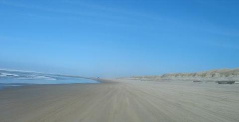
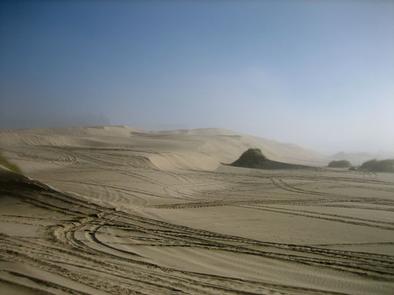
South Jetty, located less than a mile south of Florence, is an ideal camping area for off-road vehicle enthusiasts. Visitors can camp, ride dunes through all hours of daylight and take in memorable views of the Pacific Ocean from atop the tall dunes of Oregon Dunes National Recreation Area. The area is the largest expanse of coastal sand dunes in North America.

Recreation

Off-road vehicle riding is the ultimate attraction here. For added variety, all beach goers can enjoy swimming and watching sea birds. In season, whales may be spotted in the ocean as well.

From the South Jetty Day-Use Area, hikers can enjoy miles of open beach and explore dune formations above the Siltcoos River. This section is separate from the off-road vehicle area.

Facilities

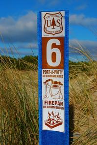
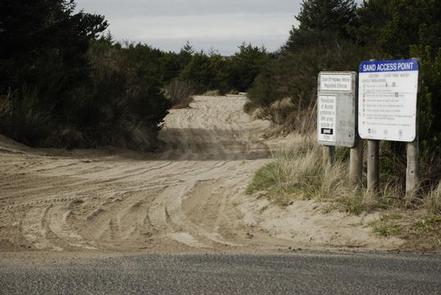
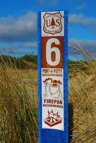
Sites can only be accessed by 4X4 vehicles. No water is available so campers should bring an ample amount. Campsites are primitive and it’s recommended that all campers bring portable toilets and fire pans. Standard sites fit five vehicles and up to 20 people. The group campsite fits 10 vehicles and 40 campers. Campsites are available year-round and reservations may fill up quickly in peak summer season.

Natural Features

Campsites are located directly on the sand, dispersed along the Pacific Coast and the Siltcoos River. The dunefield is known for its wind-sculpted sand dunes towering up to 500 feet above sea level. Siuslaw National Forest extends from Tillamook to Coos Bay along the coast of Oregon.

Nearby Attractions

Golfing is nearby and visitors can drive east to hike the foothills of the Oregon Coast Range.

Reservation

More from CampingHiking.net:

SLIDE GROUP AREA, New Mexico Campground Images, Info & Reservations

Listen Directions Located in southeast New Mexico, Slide Group Area is approximately 20 miles east of Alamogordo. From Alamogordo, take Highway 82 east 16 miles. Just before Cloudcroft, turn right (south) on Highway 130, go approximatley 2 miles. Turn right (west) on NM 6563, the Sunspot Highway Go approximately 1/4

FROSTY BAY CABIN, Alaska Campground Images, Info & Reservations

Listen Directions This cabin is on the south shore of Frosty Bay, which is on the Cleveland Peninsula of the mainland. Access is 32 miles by float plane or 36 miles by boat from Wrangell. There is a mooring buoy anchored in the bay for use by cabin guests only.

BEAR CREEK, Texas Campground Images, Info & Reservations

Listen Directions From Interstate 20 or 820 in southwest Fort Worth, take exit 429A for Highway 377 toward Granbury and go south 5.7 miles (9.2 km); turn left or southeast onto FM Road 1187 and continue for 1.4 miles (2.2 km), then turn left or east onto Ben Day-Murrin Road

Bear Creek Horse Camp, Tennessee Campground Images, Info & Reservations

Listen Directions From 1-75 Northbound, take exit 141 for Oneida/Huntsville and turn left. Follow Highway 63 to the intersection of US-27 in Huntsville. Turn right and continue north on US-27 through Oneida for 18 miles. Turn onto KY-92 West and travel approximately 1.3 miles. Bear left onto Highway 1651. Travel

BOULDER BASIN, California Campground Images, Info & Reservations

Listen Directions From Idyllwild, travel north for about 8 miles on State Route 243. Turn right onto Black Mountain Road/Forest Route 4S01 and continue about 5 miles to the campground. Black Mountain Road is an unpaved forest road, not recommended for low clearance vehicles or trailers. Phone 909-382-2922 Activities BIKING,