IDLEWILD, OR Campground Reservation, Info, Images, Map, Directions

IDLEWILD, Oregon Campground Images, Info & Reservations

Directions

From Burns, OR: Travel northeast toward Vale 2.8 miles on US Highway 20 to the junction with US Highway 395, turn left onto US Highway 395 and head north. Follow US Highway 395 for approximately 14.6 miles to the junction with Forest Road 2820. Turn right and continue on Forest Road 2820 for 0.8 miles to the junction with Idlewild Campground Road. Turn right after the Sno-Park and follow Idlewild Road for approximately 1 mile to the campground.

Phone

541-573-4300

Activities

CAMPING, HIKING, MOUNTAIN BIKING, CROSS COUNTRY SKIING, SNOWMOBILE TRAILS

Keywords

IDLE,MALHEUR NF – FS

Related Link(s)

Rec Area Info & Images

Oregon State Tourism

Oregon State Road Conditions

Overview

Idlewild Campground is the perfect place for large gatherings in any weather. In sun, rain or snow, there are plenty of ways to enjoy the outdoors while spending time with friends and family.

The campground is situated along Highway 395 north of Burns, Oregon. In the summer, it is popular with hikers and mountain bikers. In the winter, visitors can snowmobile and cross-country ski.

Recreation

Idlewild offers opportunities for camping, picnicking, hiking and mountain biking. Devine Summit Trail begins within the campground. Snowmobiling and cross-country skiing bring visitors to the area in the winter.

Facilities

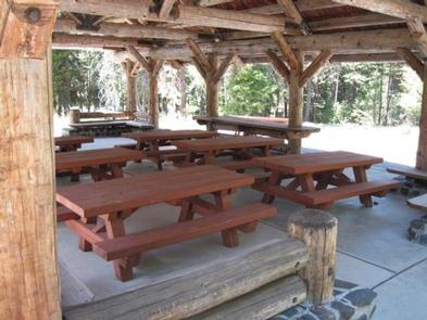
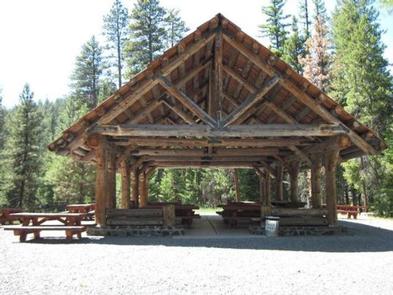
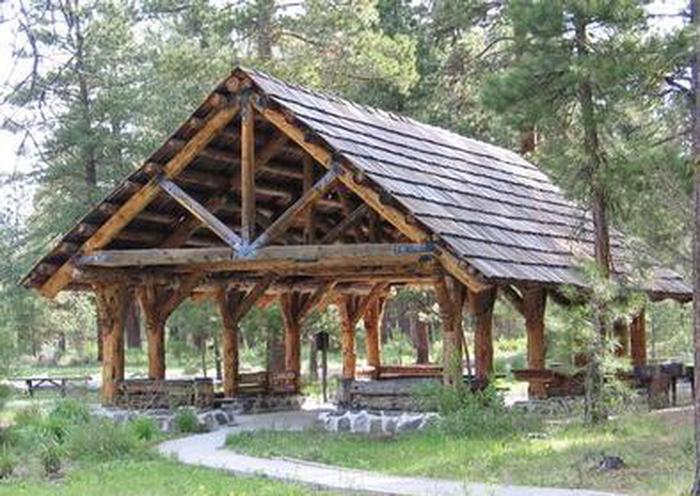
Idlewild contains one accessible, group day-use picnic shelter available for reservations for up to 75 people. It is equipped with picnic tables, a campfire ring and grills. Vault toilets and drinking water are provided. Individual sites for overnight camping are available on a first-come, first-served basis.

Natural Features

The campground is situated at an elevation of 5,000 feet in a large stand of Ponderosa pines. The group shelter sits near a meadow within Idlewild Campground. The Malheur National Forest encompasses 1.46 million acres in the Blue Mountains of eastern Oregon. The forest’s dramatic landscapes include the Strawberry Mountain Wilderness, with 9,038′ Strawberry Mountain, which extends east to west through the heart of the forest, and the Monument Rock Wilderness along the eastern boundary.

Nearby Attractions

The campground is located a short drive from Burns, Oregon. There are horse trails and equestrian camping within 10 miles of Idlewild.

Reservation

More from CampingHiking.net:

CLEAR LAKE (OR), Oregon Campground Images, Info & Reservations

Directions From Sandy, travel east on Highway 26 for about 35 miles. Turn onto Forest Road 2630 and continue for 1 mile to the campground. Phone 503-630-5721 Activities BOATING, CAMPING, FISHING, WINTER SPORTS, WILDLIFE VIEWING, SWIMMING SITE Keywords CLLA,MT. HOOD NF – FS Related Link(s) Rec Area Info & Images

KEYESPORT REC. AREA, Illinois Campground Images, Info & Reservations

Directions From I-70, take State Route 127 south for 10 miles. Turn east on Clinton Road, continue east for four miles to the town of Keyesport, then follow signs to the recreation area. Phone 618-594-5253 Activities BOATING, CAMPING, FISHING, SWIMMING SITE Keywords KEYS,CARLYLE LAKE Related Link(s) Rec Area Info &

CRANES MILL PARK, Texas Campground Images, Info & Reservations

Directions From IH 35 take Exit 191 north of New Braunfels, Texas. FM 306 is exit 191. Drive west on FM 306 for about 14 miles. Turn left on FM 2673 at the red light just after the first Guadalupe River crossing. Cranes Mill Park is located at the westernmost

WINHALL BROOK, Vermont Campground Images, Info & Reservations

Directions From Brattleboro, Vermont, travel 30 miles north on Route 30. Turn north onto Route 100 and continue for 2.5 miles. Turn onto to Winhall Station Road and follow for a mile to the campground. From Manchester, Vermont, travel 5 miles east on Route 11. Turn right onto Route 30

PINNACLES CAMPGROUND, California Campground Images, Info & Reservations

Directions Pinnacles National Park is located 32 miles south of Hollister, CA on Hwy 25 and 29 miles northeast of King City, CA on Hwy 25. Campground is located on the east side of Pinnacles National Park off Hwy 25. Phone 831-200-1722 OR GO TO WWW.VISITPINNACLES.COM Activities CLIMBING, CAMPING, INTERPRETIVE

SULOIA LAKE CABIN, Alaska Campground Images, Info & Reservations

Directions Accessible generally from late April through mid November. Located 30 air miles northwest of Sitka on Chichagof Island (within West Chichagof-Yakobi Wilderness Area). Access by floatplane takes about 20 minutes from Sitka. For geographic features surrounding cabin, refer to USGS topographic map Sitka B-6. Phone 907-747-6671 Activities BOATING, CAMPING,