STANDING INDIAN CAMPGROUND, NC Campground Reservation, Info, Images, Map, Directions

STANDING INDIAN CAMPGROUND, North Carolina Campground Images, Info & Reservations

Directions

From Franklin, North Carolina, take U.S. Highway 64 west approximately 12 miles, passing through Winding Stair Gap. Near the bottom of the mountain from the gap, turn left on West Old Murphy Road (State Route 1448) and watch for a directional sign for the campground. Go 1.9 miles and turn right on Forest Road 67 at the Standing Indian Campground sign. This is a paved road. Go 1.7 miles and turn right into the campground.

Phone

828-524-6441

Activities

CAMPING, FISHING, HIKING, HUNTING, DAY USE AREA

Keywords

STIN,NFs IN NORTH CAROLINA – FS

Related Link(s)

Rec Area Info & Images

North Carolina State Tourism

North Carolina State Road Conditions

Overview

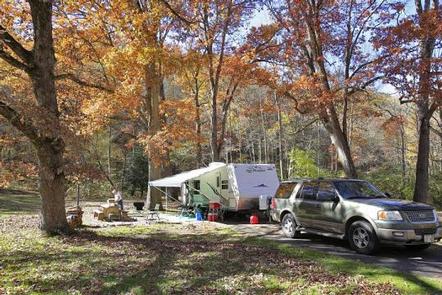
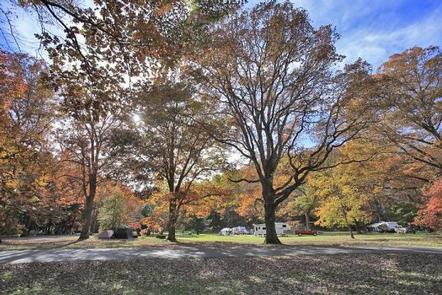
Whether traveling with an RV or tent, Standing Indian Campground is a prime place to stop for a night or spend several days in the picturesque Nantahala National Forest. The campground’s many amenities provide a comfortable home base for exploring this fun and historic section of the forest. Standing Indian is located within a 20-minute drive of Franklin, North Carolina.

Recreation

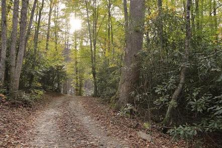
The Standing Indian Basin is a premier hiking destination. The campground provides access to numerous trails, including the world-famous Appalachian Trail, which journeys from Georgia to Maine.

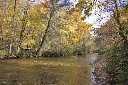
Visitors who wish to get their feet wet can experience the Nantahala River, well-known for whitewater rafting, kayaking and trout fishing (fishing license required).

Big and small game hunting is available in the surrounding area.

Facilities

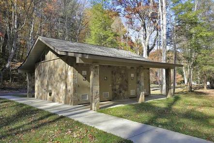
The campground has four loops with sites available first-come, first-served or by reservation. Sites are equipped with campfire rings, grills, lantern posts and picnic tables, and are in close proximity to drinking water, flush toilets and showers. A dump station is nearby. The campground also has a group camping area, Kimsey Creek.

Natural Features

The campground is surrounded by 5,000′ peaks and crossed by several natural streams. It sits at an elevation of 3,880 feet at the headwaters of the scenic Nantahala River, amidst lush forests of evergreen trees and rhododendrons.

Charges & Cancellations

There is not a premium type site available but there is some nonelectric double site that is $40.00 per night.

Reservation

More from CampingHiking.net:

WISHON CABIN, California Campground Images, Info & Reservations

Directions From Porterville,California, take Highway 190 east. Continue through Springville for approximately 8 miles to Wishon Drive. Turn left and travel about 4 miles. The cabin is at the entrance to Wishon Campground on the right hand side of the road. From Bakersfield, California, take Highway 65 North to Highway

CARLTON, California Campground Images, Info & Reservations

Directions From Downieville, travel south on Highway 49 for just over 13 miles. The campground is on the left side of the highway. Phone (530)478-6253 Activities BOATING, CAMPING, FISHING, HIKING, HUNTING, WATER SPORTS, SWIMMING SITE Keywords CRTN,TAHOE NF – FS Related Link(s) Rec Area Info & Images California State Road

NORTH SANDUSKY DAY-USE, Illinois Campground Images, Info & Reservations

Directions From I-57 take take exit 77, and turn west onto Route 154. Continue for 4.5 miles, then turn south on Rend City Road. Continue through the stop sign to the park entrance. Phone 618-724-2493 Activities BIKING, BOATING, HIKING, SWIMMING SITE, DISC GOLF Keywords NSAD,REND LAKE,NORTH SANDUSKY,NORTH SANDUSKY DAY USE,NORTH

COWPUNCHER GUARD STATION, Utah Campground Images, Info & Reservations

Directions From Highway 12 in Escalante, turn north on 300E. Drive 14 miles to the junction of Forest Roads 154 and 153. Continue on FR153 for 4.5 miles. Turn left on FR145 towards Cowpuncher and Blue Spruce Campground. Travel 0.7 miles to Cowpuncher Gate. The cabin is 0.2 miles past

MAUMELLE, Arkansas Campground Images, Info & Reservations

Directions From Little Rock, Arkansas, travel west on SR-10. Turn north on Pinnacle Valley Road and follow signs into campground. 9009 Pinnacle Valley Road Little Rock, AR 72223 Phone 501-868-9477 Activities BOATING, CAMPING, FISHING, HIKING Keywords MAUM,MURRAY LOCK AND DAMR – ARK.RIV,MURRAY LOCK & DAM Related Link(s) Rec Area Info