

Directions
From Pomeroy, take 15th Street south which turns into Peola Rd and follow for 8 miles. The road then turns into Mountain Road, follow for 7.5 miles on pavement to the forest boundary. Continue on Forest Service Road 40 for 9 miles to Clearwater Junction (where the fire lookout is located). Turn left onto FSR 42 for 0.25 mile, and then turn right into the Clearwater Guard Station area. The rental cabin is the two-story building. Automobile access to the site runs from June 1 to November 1, depending on weather conditions.
In winter, access is by snowmobile, snowshoes or cross country skis only. Parking is at Rose Spring Sno-Park, and a Sno-Park permit is needed prior to arrival. From there, visitors can follow FSR 40 for 6.5 miles and turn left onto FSR 42 for another .4 miles turning right at cabin sign and traveling another .1 mile to the cabin. Most of the 7 mile trail is groomed, except for the .5 mile on FSR 42 and the driveway down to the cabin.
Know the weather forecast before leaving as winter weather can change quickly.
Phone
509-843-1891 OFFICE HOURS MONDAY-FRIDAY 12:30-4:30 CLOSED WEEKENDS & HOLIDAYS
Activities
HIKING, HORSEBACK RIDING, WINTER SPORTS
Keywords
CLWB,Clearwater,Clear water,Big House,Clear water house,UMATILLA NF – FS
Related Link(s)
Washington State Road Conditions
Overview
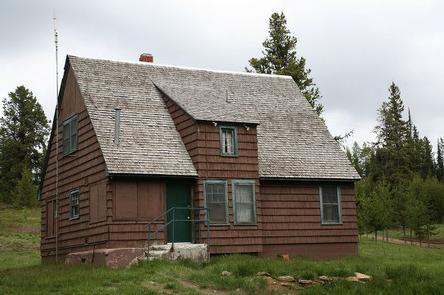
Clearwater Big House gives the feel of a winter chalet hideaway, even during the warmest months of the summer. Hiking, horseback riding and scenic drives abound, delighting guests year after year. The Clearwater Lookout Tower is a mile away. The tower is not open, but the area is nice for scenic views.
An old trapper cabin was located at the current site and was later used as a ranger station. From 1928-29, a ranger built a three-room house and by 1933, the Civilian Conservation Corps was tasked with building a barn, warehouse, outhouse and garage.
In winter, the cabin is well-suited for snowmobiling and cross country skiing on groomed snowmobile trails. These modes of over-snow transportation are required for winter access to the cabin.
Recreation
The cabin provides nearby access to hiking and horseback riding trails that lead to Teal Springs and the lush Tucannon River Drainage. The scenic drive along the Tucannon River Drainage to Sunset Point is also a recommended activity.
In winter, snowmobiling, cross country skiing and snowshoeing trails are right out your front door.
Facilities
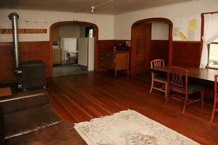
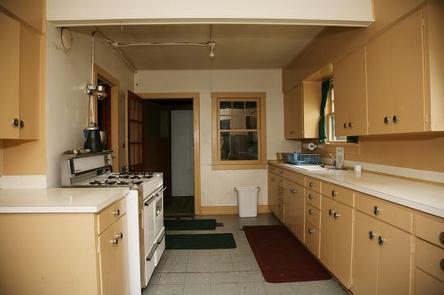
The cabin has 868 square feet of living space on the first floor, and another 336 square feet upstairs, and can accommodate up to 10 people. It is fully furnished with 3 queen, 1 full, and 5 twin beds, and a dining table and chairs. Propane heat and lighting are included, and the kitchen is equipped with a propane cook stove and refrigerator. The cabin does not have indoor bathroom facilities. There is an outdoor fire ring and a picnic table. An outhouse is located across the road. Cabin should be cleaned before your departure. Mop, bucket and cleaning supplies provided.
No water is provided. Guests need to bring plenty of water for drinking, cooking, and washing. They should also bring cooking pots and utensils, bedding or sleeping bags, dish soap, matches, a flashlight and all other basic camping items.
Natural Features
Set on a gently rolling slope at an elevation of 5,600 feet, the cabin is nestled in a clearing dotted with young Christmas trees. The Wenaha-Tucannon Wilderness is nearby, stretching across the northern Blue Mountains of southeastern Washington and northeastern Oregon.
The mountain slopes are carpeted with bunchgrass, lodgepole pine and subalpine fir. An array of wildlife, including Rocky Mountain Elk, bighorn sheep, white-tailed and mule deer, black bears, cougars and coyotes, may be spotted.
Nearby Attractions
The nearest general stores and gas stations are in Pomeroy, a 40-minute drive from the cabin.