Directions
From Livingston, Montana, travel north on Highway 89 to Wilsall. Just north of Wilsall, turn northeast onto Shields River Road. Continue 8 miles to Porcupine Road, turn east (right) and then drive another 8 miles to the cabin. Four-wheel drive vehicles are recommended due to the road condition.
During the winter, the last two miles of the road to the cabin are not plowed. Skis, snowshoes or snowmobiles are required to reach the cabin.
Phone
406-222-1892
Activities
BIKING, CAMPING, HIKING, WINTER SPORTS, WILDLIFE VIEWING
Keywords
PORK,PORCUPINE GUARD STATION,PORCUPINE,GALLATIN NF – FS
Related Link(s)
Overview
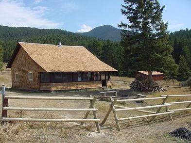
Porcupine Cabin sits in the foothills of the Crazy Mountains at an elevation of 6,400 feet. It was built in 1914 after a previous structure burned down, and was remodeled by the Civilian Conservation Corps in 1934. Since its construction, the cabin has been used as temporary housing by Forest Service rangers while they were patrolling for timber poachers, watching for fires and monitoring livestock. Today, it is available year-round to outdoor enthusiasts, offering access to a variety of activities.
Guests can drive to the cabin in the summer, but a high-clearance, four-wheel drive vehicle is recommended due to road conditions. Winter access requires snowshoeing, skiing or snowmobiling up to 2 miles from the end of the maintained gravel road.
Guests are responsible for their own travel arrangements and safety, and must bring several of their own amenities.
Recreation
Guests can access the nearby trailhead for hiking, mountain biking and equestrian use, heading east into the Crazy Mountains. The trails are used by snowshoers and cross-country skiers in the winter.
Facilities
The 26 x 44 frame house has three rooms and a screened front porch. It has bunk beds with mattresses to accommodate up to eight people. It has a table and chairs, some cleaning equipment and a propane lantern available for use. A wood stove is available to heat the cabin.
FIREWOOD IS NOT AVAILABLE FROM JUNE 1ST THROUGH SEPTEMBER 30TH. PLEASE BRING FIREWOOD OR GATHER FROM FOREST DURING SUMMER.
DO NOT BURN PROVIDED FIREWOOD FOR OUTDOOR FIRES, EVER, AS IT IS EXTREMELY DIFFICULT TO REPLACE. Firewood is available for indoor use during winter as long as supplies last. An axe and splitting maul should be available.
An outhouse with vault toilet is located behind the cabin. A campfire ring is out front. (Please bring wood to burn outside).
Water, electricity and propane canisters for the lantern are not provided. Guests need to bring their own drinking water, cooking gear and food, bedding, fire starters (matches and newspaper), extra toilet paper, flashlights, first aid kit, cookware, dishes and utensils, among other necessities. The cabin will need to be cleaned and all trash carried out.
Equestrian trails are located nearby, and a small pasture near the barn is available for cabin renter’s stock. Please be aware that the pasture fence may not be secure. Stock is not allowed near the cabin or inside the cabin fence.
Natural Features
The cabin sits on a hillside overlooking the grasslands of Shields Valley. This vantage point provides a majestic view of the Bridger Mountains and spectacular star gazing on a clear night. Guests can look out at the northern peaks of the Crazies from the front porch. Porcupine Cabin offers a quiet and fairly isolated retreat, however, there may be some passing traffic from recreational users accessing the nearby trailhead. Deer, moose, bears and elk may be spotted nearby. Several bird species that inhabit this area include bald eagles, owls, jays, western meadowlarks and mountain bluebirds.


