

Directions
From Livingston, travel south on Highway 89 for approximately 15 miles. Turn left (east) on Mill Creek Road 468. From this point, it is approximately 12 miles to the cabin along a paved then gravel road. The cabin (marked as the Mill Creek Work Center) will be on the right, just before the Snowbank Campground. In winter, the road is plowed to the Snowbank snowmobile parking area, which is beyond the cabin.
Phone
406-222-1892
Activities
CAMPING, FISHING, HIKING, WINTER SPORTS, WILDLIFE VIEWING
Keywords
MILC,Mill Creek Work Center,Mill Creek Guard Station,GALLATIN NF – FS
Related Link(s)
Overview
Mill Creek Cabin was built in 1927 as a temporary lodging for traveling Forest Service personnel.
The cabin can be accessed by vehicle year-round, though a four-wheel drive vehicle is recommended. Guests are responsible for their own travel arrangements and safety. This cabin offers rustic accommodations with limited amenities, so guests need to bring most of their own supplies and gear for a comfortable stay.
Recreation
Hikers and equestrians can access trailheads that lead into the Absaroka-Beartooth Wilderness. Anglers can fish for Yellowstone cutthroat trout in Mill Creek. Huckleberry-picking is a popular pastime when in season. Winter recreation includes cross-country skiing, snowshoeing and snowmobiling on the Mill Creek Snowmobile Trail. The cabin also offers easy access to the Snowbank and and Passage Creek Falls ski trails.
Facilities
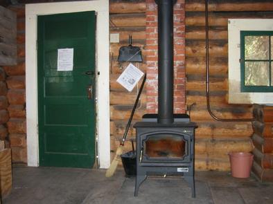
This 20-by-14 log structure has a front and back porch. It has bunk beds with mattresses to accommodate up to four people. Other amenities include a table with chairs, wood-burning stove for heat. It also has an electric range and electric lights. Water is available in the cabin from mid-June to mid-September. FIREWOOD IS NOT AVAILABLE FROM JUNE 1ST THROUGH SEPTEMBER 30TH. PLEASE BRING FIREWOOD OR GATHER FROM FOREST DURING SUMMER. DO NOT BURN PROVIDED FIREWOOD FOR OUTDOOR FIRES, EVER, AS IT IS EXTREMELY DIFFICULT TO REPLACE. Firewood is available for indoor use during winter as long as supplies last. The front porch has a picnic table and benches. A campfire ring( bring your own wood) and outdoor vault toilet are located near the cabin. A corral for up to four horses is located across from the parking area and has running water and a trough during the summer months. Water is not available at the cabin from mid-September through mid-June, so guests need to provide their own drinking water. Guests also need to bring cookware, utensils, bedding, fire starting materials (newspaper and matches), flashlights, first aid supplies and extra toilet paper. The cabin and corrals (if used) should be cleaned and all trash removed prior to leaving.
Natural Features
Mill Creek Cabin is tucked into the Absaroka Mountains, at an elevation of 5,750 feet. The cabin sits at the edge of a meadow in front of a stand of evergreens. The back porch overlooks bubbling Mill Creek, a tributary of the Yellowstone River.
Deer, elk and black bears are sometimes visitors to this area. Bird species that inhabit this area include bald eagles, owls, jays, western meadowlarks and mountain bluebirds.