
Directions
From Newman Creek, foot, ski and horse travel are accommodated. To reach the trailhead, travel south off Interstate 90 (exit 316) on Trail Creek Road for approximately 7 miles, then west on Newman Creek Road to the trailhead (1 mile). The trail to the cabin is 2.2 miles, with the first 1.7 miles crossing private property, so please stay on the trail. For those coming from the south; the Newman Creek Road turnoff is 5.5 miles north of the Trail Creek Road/Divide Road junction. During winter months, Newman Creek Road may not be plowed and an additional 1-mile ski might be necessary to reach the cabin. During wet weather, this trail may be very muddy .
From Goose Creek, snowmobile and off-road vehicle travel (check travel map or call district for dates allowed) are accommodated. To reach this trailhead, travel south off Interstate 90 (Exit 316) on the Trail Creek Road for 3 miles, then east on Goose Creek Road for 2 miles to the locked gate. Parking is available at this point. The cabin is located 5.2 miles further up the road. Off-road vehicles must be less than 50 inches wide to maneuver through a slot in the Goose Creek Gate, and are allowed only certain times of the season.
It is recommended that winter renters carry topographic maps and compasses for navigation, since the route may be difficult to find due to weather conditions.
Phone
406-222-1892
Activities
CAMPING, HIKING, HORSEBACK RIDING, WINTER SPORTS, WILDLIFE VIEWING
Keywords
TRCC,TRAIL,TRAIL CREEK,TRAIL CABIN,CREEK CABIN,GALLATIN NF – FS
Related Link(s)
Overview
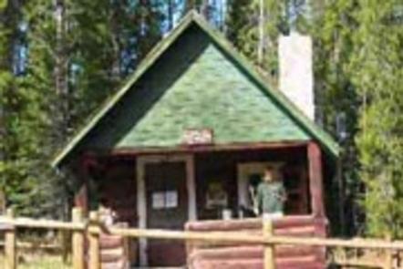
Trail Creek Cabin, built in 1924, was the original ranger station for the Bozeman Ranger District. It is available year round, offering guests the chance to enjoy summer or winter recreation. The cabin is located in a remote area that is not accessible by car or truck. Guests must travel on foot, horseback, motorized vehicle (under 50) or mountain bike. In winter, skis, snowshoes or snowmobiles may be used to reach the cabin. The best route for arriving on foot or horseback is about 2 miles, while motorized vehicles (under 50), and snowmobiles have a 5-mile route. Call the district office M-F, 8 to 4:30, for latest road/trail conditions. Check Travel Plan for restrictions and authorized dates. Guests are responsible for their own travel arrangements and safety, and should be prepared to bring supplies and gear they need for a comfortable stay.
Recreation
The cabin is located along a trail system that connects the Yellowstone and Bozeman Districts. A hiking and equestrian trail at the end of Goose Creek Road leads to several alpine lakes. Snowy conditions in winter provide ample opportunities to snowshoers, cross-country skiers and snowmobilers.
As an addition to non-mortorized use, the Trail Creek Cabin provides wonderful opportunites for the motorized use community. In additon to accessing the cabin by atv, motorcyle or utvs under 50″, the area has several opportunities for looped riding trials as well as scenic overlooks. This cabin can also be accessed via the Bear Canyon Trail by motorized (under 50″) use. Please see Travel Plan for the latest seasonal trail restrictions.
Facilities
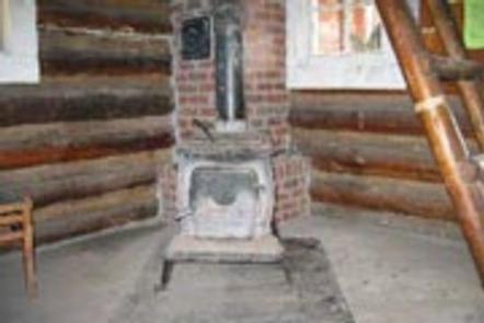
The cabin has bunk beds with mattresses to accommodate up to four people. A wood stove is available to heat the cabin. Other amenities include a table with chairs, propane lantern, shovel, bucket, mop and broom. The cabin is stocked with firewood from OCTOBER THROUGH MAY for indoor fires only. An axe and splitting maul are provided. Please be conservative of the firewood as it is extremely difficult to replace. Gather firewood for outdoor fires from the forest nearby. Do not use the provided firewood for outdoor fires. A campfire ring and an outhouse with vault toilet are located outside. A horse corral is provided for four animals, and guests who use it must clean it before leaving. Feed must be weed seed free, and out of state horses must have a current Coggins test. WATER SOURCES ARE UNRELIABLE DUE TO STREAM FLOWS. THERE MAY BE NO NEARBY WATER SOURCE. The cabin does not offer electricity or water. Guests must bring their own drinking WATER, food, cooking gear and propane canisters for the lantern, as well as their own bedding, dishes, utensils, matches, newspaper, flashlights, garbage bags, extra toilet paper, a first aid kit and dish soap, among other necessities. The cabin will need to be cleaned and all trash removed prior to leaving.
Natural Features
The cabin is located in the foothills of the Gallatin Mountains at an elevation of 6,200 feet. It is situated on the edge of a meadow in front of a stand of lodgepole pine. The front porch of the cabin offers views of the meadow with the mountain peaks beyond. A small intermittent creek flows behind the cabin. Guests may catch a glimpse of a bear, moose, elk or deer. Several bird species can also be spotted.