
Directions
From Philipsburg, travel west on Rock Creek Road/County Road 348 for approximately 14 miles, then turn right onto Rock Creek Road/County Road 102 and continue about 5 miles. Turn left at Stony Creek Road/County Road 241 and the cabin is about a quarter-mile on the right. Depending on snow conditions, the last quarter-mile may be impassable during the winter. Maps may be purchased by calling the Pintler Ranger District.
Phone
406-859-3211
Activities
CAMPING, FISHING, HIKING, HUNTING, WINTER SPORTS, WILDLIFE VIEWING
Keywords
STNY,BEAVERHEAD-DEERLODGE NF -FS
Related Link(s)
Overview
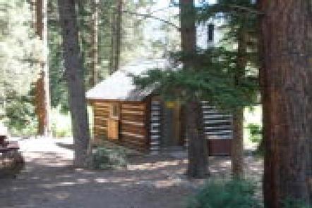
Stony Cabin is a small primitive cabin that was built in 1914 as a place for Forest Service employees to sleep while working in the area. The cabin is situated close to Stony Creek Road and across the street from Stony Creek Campground. It is not remote but ideal for those who want to stay in a cabin while friends camp across the street at the campground.
It provides access to Rock Creek, a Blue Ribbon Trout Stream, and Stony Creek. The cabin is within close proximity to a variety of hiking and biking trails also. Guests can enjoy winter recreation on those same trails when there is snow in the area, typically from December until April of each year. The cabin is available all year, offering the opportunity to experience the backcountry of western Montana in all seasons.
The cabin can be accessed by vehicle most of the year. There is limited parking in the driveway and trailers are not recommended. Guests are responsible for their own travel arrangements and safety, and must bring their own personal amenities.
Recreation
Fishing is available in Rock and Stony Creeks and anglers might find plentiful brook, brown and rainbow trout. Much of the stream is protected from bull or west slope cutthroat trout fishing to improve the fishery. Big game hunting is possible in designated areas. Appropriate licensing is required to fish and hunt in Montana.
A variety of hiking, mountain biking, ATV and horseback riding trails as well as old roads climb into the steep drainages and canyons of the Bitterroot Range. The trail at the end of Forest Road 241 leads to Stony Lake at over 8,000 feet in elevation.
Guests also enjoy snowmobiling, cross country skiing and snowshoeing in the area during the winter.
Facilities
The cabin is equipped with two sets of bunk beds with mattress pads that can sleep up to four people. It has a wood stove for heat and a small table with chairs. Some pots and pans are provided, but guests should consider bringing their own. The cabin is seasonally stocked with firewood but it is not guaranteed. Brooms and mops are provided for cleaning. Accessible vault toilets and seasonally available drinking water are available in the campground across the road from the cabin. Guests are advised that this cabin is across the road from Stony Creek Campground and not in an isolated area.
Electricity is not available. Guests need to bring their own propane stove, sleeping bags, pillows, towels, flashlights or lanterns, matches and lighters, garbage bags and a first aid kit, among other necessities. All garbage and food must be packed out, and guests must clean the cabin prior to leaving. The cabin has external wooden shutters that need to be closed as well.
Cell phone service is not available at the cabin.
Natural Features
Many older maps still refer to this cabin as the Squaw Rock Cabin because the notable Squaw Rock formation overlooks the site. This cabin is right off of Stony Creek Road and across from Stony Creek Campground in the Beaverhead-Deerlodge National Forest. The cabin is very close to the confluence of Rock and Stony Creeks.
The area is known for its high, rugged and beautiful mountain scenery, as well as the variety of wildlife that makes its home there, including bighorn sheep, elk, moose, deer, mountain lions and bears (learn more about bear safety).
Charges & Cancellations
Reservations are nonrefundable unless extenuating circumstances warrant otherwise. Determination will be made on a case by case basis.