JOHNSON BAR GROUP SITE, ID Campground Reservation, Info, Images, Map, Directions

JOHNSON BAR GROUP SITE, Idaho Campground Images, Info & Reservations

Directions

Johnson Bar Group Site is located 4.5 miles east of Lowell, ID on Forest Road 223 (Selway River Road). The group site is between the paved road and the river.

Phone

208-926-4258

Activities

BOATING, HISTORIC & CULTURAL SITE, CAMPING, FISHING, HIKING, WILDLIFE VIEWING

Keywords

JOHB,NEZPERCE NF – FS,JOHNSON BAR CAMPGROUND

Related Link(s)

Rec Area Info & Images

Idaho State Road Conditions

Idaho State Tourism

Overview

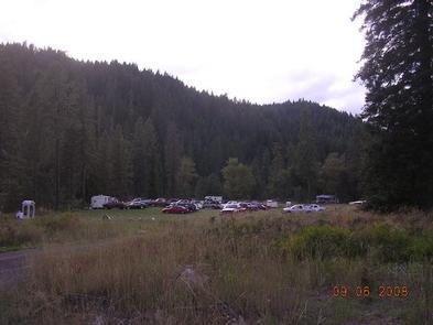
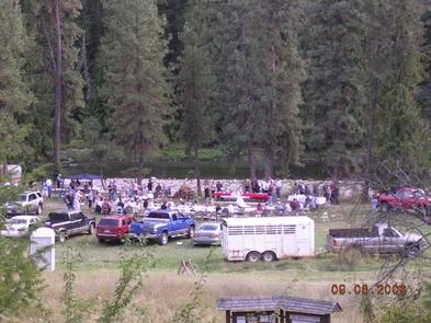
Johnson Bar Group Site is situated in a large, open field along the Selway River. The site is perfect for gatherings of up to 100 people, with room for tents and RVs. The site offers access to many recreational activities and sightseeing opportunities.

Recreation

The Selway River is a destination fly fishing experience for cutthroat and rainbow trout and is also well-known for whitewater rafting. Several trailheads for hiking and biking are accessible from Selway River Road and lead into the Selway-Bitterroot Wilderness area. Johnson Bar offers beach and boating access.

Facilities

The accessible group site can accommodate a maximum of 100 people. It is equipped with a campfire circle, two smaller campfire rings, picnic tables and drinking water. Vault toilets are adjacent to the site, and groups of 25 or more are required to rent 1-3 portable toilets.

Individual campsites are located on either side of the group site on a first-come, first served basis.

Natural Features

In the heart of north central Idaho, rugged peaks, deep canyons, dense forests and remote wilderness comprise the Nez Perce National Forest. Due in large part to dramatic elevational differences, the forest supports a wide variety of vegetation, from cedar groves to desert ecosystems.

Johnson Bar is located in the Selway Wild and Scenic River Corridor, an area known for its rugged natural beauty and wildlife.

Nearby Attractions

An 11-mile sightseeing drive from Lowell to Selway Falls offers visitors opportunities to appreciate the pristine beauty of the Selway Wild and Scenic River and picturesque Selway Falls.

Johnson Bar is near the Fenn Ranger Station, which is on the National Register of Historic Places.

Reservation

More from CampingHiking.net:

MEADOWS CABIN, Wyoming Campground Images, Info & Reservations

Directions From Afton, WY, take Highway 89 north approximately 31 miles to Alpine, WY. At Alpine, turn right (south) onto Greys River Road (Forest Road 10138) and drive about 26 miles to Box Y Guest Lodge turnoff. Turn right (west), cross the Greys River Bridge, and then travel 1/4 mile.

DEEP CREEK GROUP CAMP, North Carolina Campground Images, Info & Reservations

Directions Seasonal phone is 828-488-3184 From downtown Bryson City, NC: Follow signs to Deep Creek, 3 miles away. Phone 828-488-3184 OR 865-436-1261 Activities HISTORIC & CULTURAL SITE, CAMPING, FISHING, HIKING, HORSEBACK RIDING, VISITOR CENTER, WILDLIFE VIEWING Keywords CG31,Great Smokey Mountains National Park,Great Smoky Mountains National Park,”Flaming Gorge National Recreation Area”

THIBAUT POINT, Missouri Campground Images, Info & Reservations

Directions From Highway 65, take Highway T west for 3 miles. Turn south on Georgetown Ave and follow for a mile, following signs into the park. Phone 660-428-2470 Activities BOATING, CAMPING, FISHING, FISH HATCHERY, SWIMMING SITE Keywords THIB,TRUMAN LAKE,TEBO,HARRY S TRUMAN Related Link(s) Rec Area Info & Images Missouri State

MIDDLE RIDGE CABIN, Alaska Campground Images, Info & Reservations

Directions Middle Ridge Cabin is located on Wrangell Island, approximately 20 miles from Wrangell, Alaska. There are no roads to Wrangell. Access is by the Alaska Marine Highway or via Alaska Airlines. From Wrangell, head south on Zimovia Highway approximately 11 miles to Pat’s Creek Road (Road 6259) and take

BUMPUS MILLS, Tennessee Campground Images, Info & Reservations

Directions From Nashville, Tenn: Take I-24 west to Clarksville, TN. Follow Highway 79 South for 20 mi. to Highway 120. Follow Highway 120 for 10 mi. to Bumpus Mills, turn left onto Tobaccoport Road (Hwy. 1830) for 2.8 mi., turn left onto Oak Hill Road for . 9 mi., turn