
Directions
From Weston, Oregon: Travel 28 miles east of Weston on Highway 204. Turn right (south) onto Forest Service Road 31. Go 9.4 miles to Ruckel Junction. Stay on Forest Service Road 31 and go 17 miles until you reach the junction with Forest Service Road 3113. Turn right onto Forest Service Road 3113 and travel about 0.8 miles to the access road to Summit Guard Station. Turn left onto the access road and follow the road to the right. From Pendleton, Oregon: Travel Interstate 84 east for 34 miles to Exit 243 (Mt. Emily Exit). Take the exit and at the stop sign turn left. Cross the freeway on the overpass and proceed past the ramps to the end of the pavement. Forest Service Road 31 starts here. Travel Forest Service Road 31 for about 12.2 miles to the junction with Forest Service Road 3113. Turn left onto Forest Service Road 3113 and travel about 0.8 miles to the access road to the Summit Guard Station. Turn left onto the access road and follow the road to the right. Automobile access to the site tends to run from mid-May through mid-November, and parking is available at the guard station. Shoulder season use may require alternate transportation such as skis, snowshoes, or snowmobile.
Phone
509-522-6290
Activities
HISTORIC & CULTURAL SITE, CAMPING, HUNTING, WILDLIFE VIEWING, MOUNTAIN BIKING, BERRY PICKING
Keywords
SUGU,SUMMIT,SUMMIT BUNKHOUSE,SUMMIT CABIN,GUARD,STATION,BUNKHOUSE,SUMMIT GUARD STATION BUNKHOUSE,SUMMIT GUARD STATION,UMATILLA NF – FS
Related Link(s)
Overview
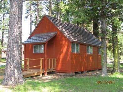
Summit Guard Station Bunkhouse sets the stage for a truly relaxing getaway. Located on the breaks of Meacham Canyon in Umatilla National Forest, spectacular views of the Blue Mountains are guaranteed. The rustic bunkhouse, built by the Civilian Conservation Corps, dates back to 1938.
The site of the cabin was the Summit Ranger Station in 1908, when the land was part of the Wenaha National Forest. Wenaha was one of the first national forests in the country, established in 1907. It was renamed Umatilla National Forest in 1920.
Recreation
Bird and wildlife watching is exceptional at Summit.
Facilities
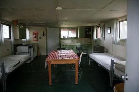
The single-room cabin accommodates up to four guests. The red, wood framed cabin has two full beds and two twin beds with mattresses, a table and four chairs, and is equipped with a propane cook stove, propane lights and a propane heater. The cabin is stocked with a limited supply of pots, pans, eating utensils and cleaning supplies. A vault toilet is located a short distance from the cabin and additional guests may use the yard to pitch a tent. No water is available on-site, so guests must bring plenty of water for drinking, cooking and washing. Other items to bring include food, bedding, towels, garbage bags, dish soap and a first aid kit. It’s a great idea to bring binoculars as well. Click here for more cabin details.
Natural Features
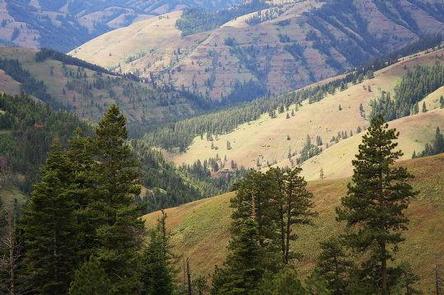
Summit Guard Station is located on a high ridge nestled in an open stand of large Ponderosa pine and Douglas fir. The view to the south and west from this ridge-top setting is exceptional. Prominent points in the area include Wilbur Mountain, Spring Mountain, Sugarloaf Mountain and Green Mountain.
Bird species in the region include kinglets, sparrows, chickadees and hummingbirds, while wildflowers include larkspur, lupine and orchids.
Nearby Attractions
The Whitman Route Overlook is a short drive away, boasting views of Meacham Canyon and the Hell Hole Roadless Area, as well as a look back into the history of the area.